
Fitxer:Geological map Britain William Smith 1815.jpg
Fitxer original (1.200 × 1.769 píxels, mida del fitxer: 456 Ko, tipus MIME: image/jpeg)
| Aquest fitxer i la informació mostrada a continuació provenen del dipòsit multimèdia lliure Wikimedia Commons. |
| Descripció |
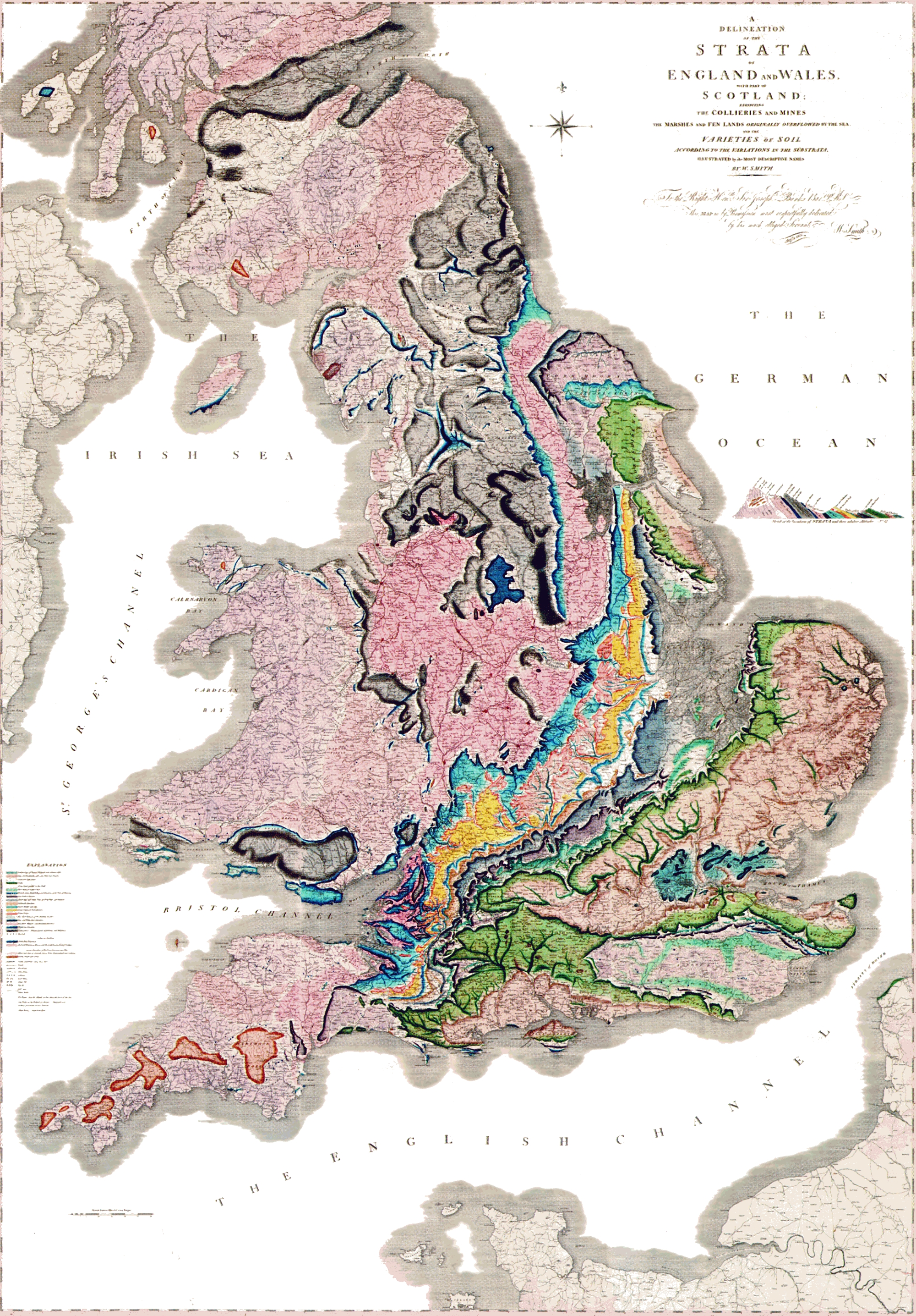
A delineation of the strata of England and Wales with part of Scotland. (The first geological map of Britain, published by William Smith in 1815) |
|||||
| Data | ||||||
| Font |
Desconegut العربية: خريطةُ وليام سميث الجيولوجية لإنجلترا وويلز وجنوب اسكتلندا، والتي تم الانتهاء منها في عام 1815م، وتُعتبر ثاني خريطة جيولوجيّة على النطاق الوطني، وكانت أدقَّ خريطةٍ في وقتها |
|||||
| Autor | William Smith (1769-1839) | |||||
| Permís (Com reutilitzar aquest fitxer) |
|
|||||

Historial del fitxer
Cliqueu una data/hora per veure el fitxer tal com era aleshores.
| Data/hora | Miniatura | Dimensions | Usuari/a | Comentari | |
|---|---|---|---|---|---|
| actual | 23:03, 29 maig 2024 | | 1.200 × 1.769 (456 Ko) | Anticline | Reverted to version as of 00:45, 11 December 2008 (UTC) as this image more accurately reflects the colouring and appearance of the map |
| 16:45, 20 oct 2014 |  | 2.000 × 2.871 (4,63 Mo) | Ivtorov | edited colors, crop. | |
| 02:45, 11 des 2008 |  | 1.200 × 1.769 (456 Ko) | Gump Stump | {{Information |Description=The first geological map of Britain, published by William Smith in 1815. |Source=[http://www.livescience.com/php/multimedia/imagedisplay/img_display.php?pic=051031_first_map_02.jpg LiveScience Image Gallery] Scan by the Library |
Ús del fitxer
Les 4 pàgines següents utilitzen aquest fitxer:
Ús global del fitxer
Utilització d'aquest fitxer en altres wikis:
- Utilització a ar.wikipedia.org
- Utilització a bg.wikipedia.org
- Utilització a bn.wikipedia.org
- Utilització a de.wikipedia.org
- Utilització a en.wikipedia.org
- Utilització a es.wikipedia.org
- Utilització a fr.wikipedia.org
- Utilització a fy.wikipedia.org
- Utilització a gl.wikipedia.org
- Utilització a he.wikipedia.org
- Utilització a hy.wikipedia.org
- Utilització a it.wikipedia.org
- Utilització a ja.wikipedia.org
- Utilització a ka.wikipedia.org
- Utilització a kk.wikipedia.org
- Utilització a la.wikipedia.org
- Utilització a ms.wikipedia.org
Vegeu més usos globals d'aquest fitxer.