
Fitxer:Island of Ireland location map Dublin.svg

Mida d'aquesta previsualització PNG del fitxer SVG: 481 × 599 píxels. Altres resolucions: 192 × 240 píxels | 385 × 480 píxels | 616 × 768 píxels | 822 × 1.024 píxels | 1.643 × 2.048 píxels | 1.450 × 1.807 píxels.
Fitxer original (fitxer SVG, nominalment 1.450 × 1.807 píxels, mida del fitxer: 642 Ko)
| Aquest fitxer i la informació mostrada a continuació provenen del dipòsit multimèdia lliure Wikimedia Commons. |
| Descripció |
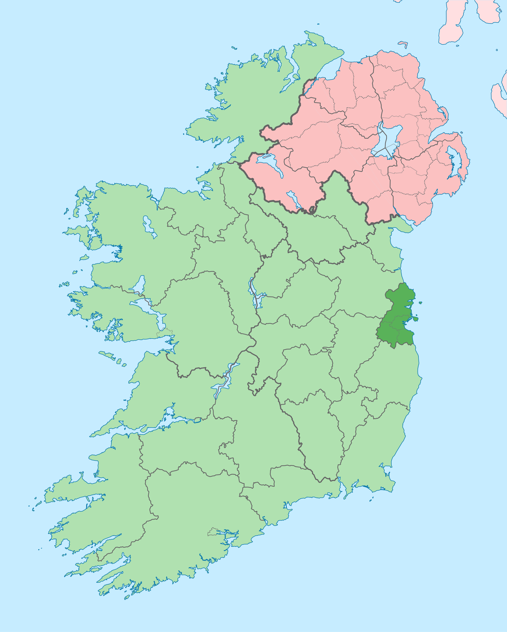
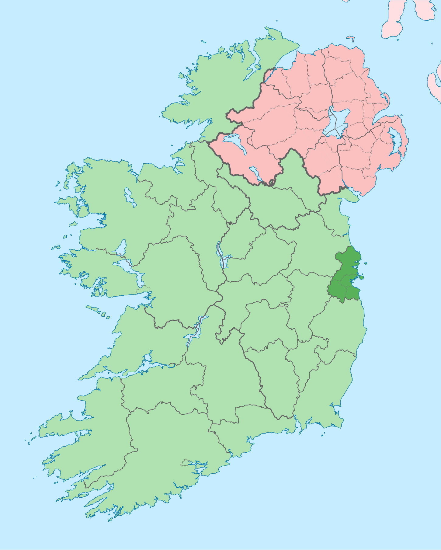
English: The island of Ireland, showing international border between Ireland and Northern Ireland, traditional provinces, traditional counties, and local authority areas in Ireland and Northern Ireland. |
| Data | (UTC) |
| Font | |
| Autor |
|
| Altres versions |
Derivative works of this file: |
| Això és una imatge retocada, cosa que vol dir que ha estat alterada digitalment de la seva versió original. Modificacions: Coloured in regions with county of article highlighted. L'original es pot veure a: Island of Ireland location map.svg:
|
Jo, el titular dels drets d'autor d'aquest treball, el public sota la següent llicència:
Aquest fitxer està subjecte a la llicència de Creative Commons Reconeixement i Compartir Igual 3.0 No adaptada.
- Sou lliure de:
- compartir – copiar, distribuir i comunicar públicament l'obra
- adaptar – fer-ne obres derivades
- Amb les condicions següents:
- reconeixement – Heu de donar la informació adequada sobre l'autor, proporcionar un enllaç a la llicència i indicar si s'han realitzat canvis. Podeu fer-ho amb qualsevol mitjà raonable, però de cap manera no suggereixi que l'autor us dóna suport o aprova l'ús que en feu.
- compartir igual – Si modifiqueu, transformeu, o generareu amb el material, haureu de distribuir les vostres contribucions sota una llicència similar o una de compatible com l'original
Registre original de càrregues
This image is a derivative work of the following images:
- File:Island_of_Ireland_location_map.svg licensed with Cc-by-sa-3.0
- 2010-03-06T20:43:33Z Rannpháirtí anaithnid 1450x1807 (679207 Bytes) Fix incorrectly coloured isands.
- 2010-03-03T22:19:29Z Rannpháirtí anaithnid 1450x1807 (679744 Bytes) {{Information |Description={{de|Positionskarte von [[:de:Irland|Irland]]}} Quadratische Plattkarte, N-S-Streckung 170 %. Geographische Begrenzung der Karte: * N: 55.6° N * S: 51.2° N * W: 11.0° W * O: 5.0° W {{en|Location
Uploaded with derivativeFX
Historial del fitxer
Cliqueu una data/hora per veure el fitxer tal com era aleshores.
| Data/hora | Miniatura | Dimensions | Usuari/a | Comentari | |
|---|---|---|---|---|---|
| actual | 11:16, 3 jul 2020 | | 1.450 × 1.807 (642 Ko) | Chipmunkdavis | Per the Local Government Reform Act 2014, joining both Tipperarys and both Waterfords (and removing Limerick City code). Colouring in islands, cleaning up and grouping code to remove stray objects and show Galway and Lough Ree. |
| 02:44, 19 jul 2010 |  | 1.450 × 1.807 (815 Ko) | Mabuska | {{Information |Description={{en|The island of Ireland, showing international border between Northern Ireland and Republic of Ireland, traditional provinces, traditional counties, and local authority areas in the Republic of Ireland and Northern Ireland.}} |
Ús del fitxer
Les 13 pàgines següents utilitzen aquest fitxer:
Ús global del fitxer
Utilització d'aquest fitxer en altres wikis:
- Utilització a ar.wikipedia.org
- Utilització a ast.wikipedia.org
- Utilització a bg.wikipedia.org
- Utilització a cs.wikipedia.org
- Utilització a da.wikipedia.org
- Utilització a en.wikipedia.org
- County Dublin
- Dublin
- Swords, Dublin
- Sydney Parade Avenue
- Northside, Dublin
- Southside, Dublin
- Merrion Centre, Dublin
- List of Ireland-related topics
- South Dublin
- Dún Laoghaire–Rathdown
- Fingal
- Template:County Dublin
- Tallaght
- List of Dublin postal districts
- Shenick Island
- Park Avenue, Dublin
- Kilmore West
- Greater Dublin Area
- Nutgrove
- Sutton Park, Dublin
- Man of War, Fingal
- Template:Dublin-geo-stub
- Heytesbury Street
- N32 road (Ireland)
- History of Belfast
- List of subdivisions of County Dublin
- North Wall, Dublin
- Sutton Creek (Ireland)
- Glenview, Tallaght
- Shandon, Dublin
- Ashtown Castle
- Red Gap
- Sandymount Avenue
- Herbert Road
- Tritonville Road
- Palmerston Park, Dublin
- Aylesbury, Tallaght
- Baldonnel, Dublin
- East Wall Road
- Annesley Bridge
- R135 road (Ireland)
- Athgoe
- Edmondstown
- Fitzwilliam Square
- Colt Island
Vegeu més usos globals d'aquest fitxer.