
Fitxer:LA2-Europe-UTM-zones.png

Mida d'aquesta previsualització: 553 × 599 píxels. Altres resolucions: 221 × 240 píxels | 443 × 480 píxels | 960 × 1.040 píxels.
Fitxer original (960 × 1.040 píxels, mida del fitxer: 219 Ko, tipus MIME: image/png)
| Aquest fitxer i la informació mostrada a continuació provenen del dipòsit multimèdia lliure Wikimedia Commons. |
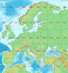
Map of Europe, showing the latitude and longitude zones of the en:Universal Transverse Mercator coordinate system, from 29S to 38W.
Bounding box West -12°, South 32°, East 48°, North 72°. Center at 52°00′N 18°00′E / 52.00°N 18.00°E.
This image is in the public domain because it came from the site https://www.demis.nl/products/web-map-server/examples/ and was released by the copyright holder. Permission is granted to copy, distribute and/or modify this map since it is based on free of copyright images from: www.demis.nl. See also approval email on de.wp and its clarification.
|
| This work has been released into the public domain by its copyright holder, www.demis.nl. This applies worldwide. En alguns països això pot no ser legalment possible, en tal cas: www.demis.nl concedeix a tothom el dret d'usar aquesta obra per a qualsevol propòsit, sense cap condició llevat d'aquelles requerides per la llei.
|
Historial del fitxer
Cliqueu una data/hora per veure el fitxer tal com era aleshores.
| Data/hora | Miniatura | Dimensions | Usuari/a | Comentari | |
|---|---|---|---|---|---|
| actual | 01:10, 2 set 2006 | | 960 × 1.040 (219 Ko) | LA2 | Map of Europe, showing the latitude and longitude zones of the en:Universal Transverse Mercator coordinate system, from 29S to 38W. Bounding box West -12°, South 32°, East 49°, North 72°. Center at {{coor d|52.00000|N|18.50000|E|scale:24000000}} |
Ús del fitxer
Les 2 pàgines següents utilitzen aquest fitxer:
Ús global del fitxer
Utilització d'aquest fitxer en altres wikis:
- Utilització a ar.wikipedia.org
- Utilització a da.wikipedia.org
- Utilització a de.wikipedia.org
- Utilització a en.wikipedia.org
- Utilització a es.wikipedia.org
- Utilització a fa.wikipedia.org
- Utilització a fi.wikipedia.org
- Utilització a fr.wikipedia.org
- Utilització a gl.wikipedia.org
- Utilització a he.wikipedia.org
- Utilització a hu.wikipedia.org
- Utilització a ja.wikipedia.org
- Utilització a nl.wikipedia.org
- Utilització a no.wikipedia.org
- Utilització a pl.wikipedia.org
- Utilització a pt.wikipedia.org
- Utilització a sr.wikipedia.org
- Utilització a sv.wikipedia.org
- Utilització a th.wikipedia.org