
Fitxer:Map of Sendai Earthquake 2011.jpg

Fitxer original (897 × 749 píxels, mida del fitxer: 606 Ko, tipus MIME: image/jpeg)
| Aquest fitxer i la informació mostrada a continuació provenen del dipòsit multimèdia lliure Wikimedia Commons. |
Resum
| Descripció |
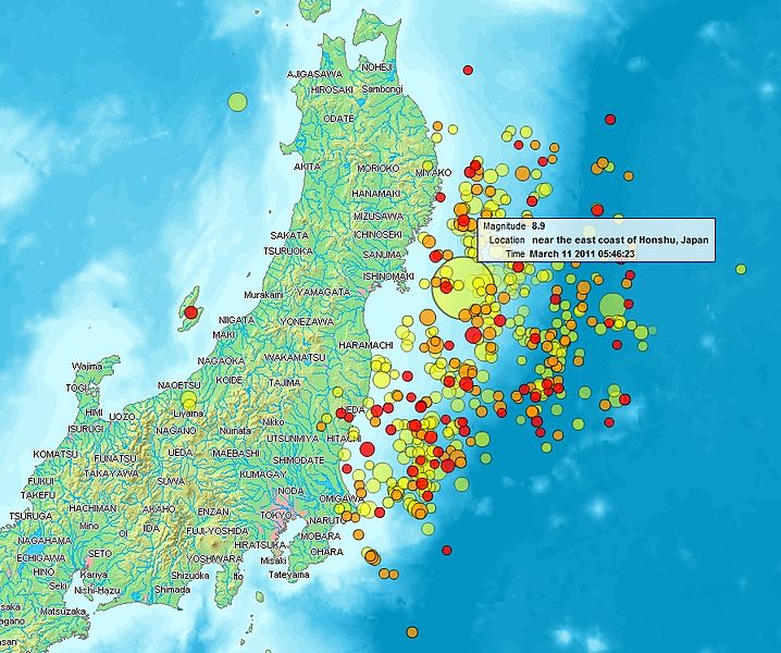
English: Map of the Sendai Earthquake 2011 and aftershocks until March 14, 2011 at 11:20. The size of the circles is a function of magnitude, and the color indicates the date: light green: March 11; yellow: March 12; orange: March 13; red: March 14.
Français : Carte des épicentres et de l'intensité des secousses du tremblement de terre de Sendai du 14 mars 2011. La taille des cercles est fonction de la magnitude, leur couleur indique la date : vert clair, 11.3.2011 ; jaune, 12.3.2011 ; orange, 13.3.2011 ; rouge 14.3.2011.
日本語: 2011年3月11日に発生した東北地方太平洋沖地震、および同14日11時20分までの余震を示した地図。円はマグニチュード、色は発生した日付(黄緑:3月11日、黄:3月12日、橙:3月13日、赤:3月14日)を示す。 |
| Data | |
| Font | http://www2.demis.nl/quakes/ |
| Autor | www2.demis.nl, Uploader User:Heinz-Josef Lücking |
| Permís (Com reutilitzar aquest fitxer) |
Public domain according to http://www2.demis.nl |
|
Aquest material està en domini públic als Estats Units i als altres països on el dret d'autor s'estén per 70 anys (o menys) després de la mort de l'autor.
| |
| Aquest fitxer està identificat com a lliure de restriccions conegudes sota la llei de drets d'autor, inclosos els drets veïns. | |
Llicència
This image is in the public domain because it came from the site https://www.demis.nl/products/web-map-server/examples/ and was released by the copyright holder. Permission is granted to copy, distribute and/or modify this map since it is based on free of copyright images from: www.demis.nl. See also approval email on de.wp and its clarification.
|
| This work has been released into the public domain by its copyright holder, www.demis.nl. This applies worldwide. En alguns països això pot no ser legalment possible, en tal cas: www.demis.nl concedeix a tothom el dret d'usar aquesta obra per a qualsevol propòsit, sense cap condició llevat d'aquelles requerides per la llei.
|
| L'ús d'aquest fitxer és regulat sota les condicions de Creative Commons de CC0 1.0 lliurament al domini públic universal. | |
| La persona que ha associat un treball amb aquest document ha dedicat l'obra domini públic, renunciant en tot el món a tots els seus drets de d'autor i a tots els drets legals relacionats que tenia en l'obra, en la mesura permesa per la llei. Podeu copiar, modificar, distribuir i modificar l'obra, fins i tot amb fins comercials, tot sense demanar permís.
|
Historial del fitxer
Cliqueu una data/hora per veure el fitxer tal com era aleshores.
| Data/hora | Miniatura | Dimensions | Usuari/a | Comentari | |
|---|---|---|---|---|---|
| actual | 23:31, 14 març 2011 | | 897 × 749 (606 Ko) | Heinz-Josef Lücking | 14.3 + legend description |
| 06:27, 13 març 2011 |  | 1.362 × 1.386 (1,41 Mo) | Stanqo | 4h05m UTC, 13.03.2011 | |
| 13:10, 12 març 2011 |  | 1.197 × 1.245 (885 Ko) | Yuma | higher resol. | |
| 12:27, 12 març 2011 |  | 928 × 694 (470 Ko) | Yuma | update | |
| 19:20, 11 març 2011 |  | 1.006 × 773 (596 Ko) | Heinz-Josef Lücking | actual 2011-03-11 18:20 | |
| 13:19, 11 març 2011 |  | 1.014 × 779 (598 Ko) | Erdbeben20110311 | actuality | |
| 11:39, 11 març 2011 |  | 1.009 × 683 (522 Ko) | Erdbeben20110311 | {{Information |Description ={{en|1=Map of the Senadai Earthquake 2011}} |Source =http://www2.demis.nl/quakes/ |Author =www2.demis.nl |Date =2011-03-11 |Permission = |other_versions = }} Public domain according to http://ww |
Ús del fitxer
Les 4 pàgines següents utilitzen aquest fitxer:
Ús global del fitxer
Utilització d'aquest fitxer en altres wikis:
- Utilització a af.wikipedia.org
- Utilització a als.wikipedia.org
- Utilització a ar.wikipedia.org
- Utilització a ast.wikipedia.org
- Utilització a az.wikipedia.org
- Utilització a bat-smg.wikipedia.org
- Utilització a bcl.wikipedia.org
- Utilització a be-tarask.wikipedia.org
- Utilització a be.wikipedia.org
- Utilització a cu.wikipedia.org
- Utilització a da.wikipedia.org
- Utilització a de.wikipedia.org
- Utilització a el.wikipedia.org
- Utilització a en.wikipedia.org
- Utilització a en.wikibooks.org
- Utilització a eo.wikipedia.org
- Utilització a es.wikipedia.org
- Utilització a es.wikinews.org
- Utilització a eu.wikipedia.org
- Utilització a fi.wikipedia.org
- Utilització a fr.wikipedia.org
- Utilització a ga.wikipedia.org
- Utilització a he.wikipedia.org
- Utilització a hr.wikipedia.org
- Utilització a hu.wikipedia.org
- Utilització a id.wikipedia.org
- Utilització a is.wikipedia.org
- Utilització a it.wikinews.org
- Utilització a ja.wikipedia.org
- Utilització a ko.wikipedia.org
- Utilització a ksh.wikipedia.org
- Utilització a lt.wikipedia.org
- Utilització a mrj.wikipedia.org
- Utilització a ms.wikipedia.org
- Utilització a nl.wikipedia.org
- Utilització a nn.wikipedia.org
- Utilització a no.wikipedia.org
- Utilització a oc.wikipedia.org
- Utilització a pl.wikipedia.org
- Utilització a pl.wikinews.org
Vegeu més usos globals d'aquest fitxer.