Fitxer:Mauna Loa summit in snow 2016.jpg

El contingut de la pàgina no s'admet en altres llengües.
De la Viquipèdia, l'enciclopèdia lliure

Mauna_Loa_summit_in_snow_2016.jpg(720 × 480 píxels, mida del fitxer: 295 Ko, tipus MIME: image/jpeg)

Descripció a Commons
Descripció
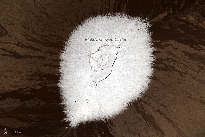
English: Snow may not be the first thing that comes to mind when you think of the Hawaiian Islands. But nearly every year, the peaks of Mauna Kea and Mauna Loa volcanoes are temporarily dusted with white. Satellites captured such events in 2014, 2015, and most recently in December 2016, pictured here.

The Operational Land Imager (OLI) on the Landsat 8 satellite captured these natural-color images of the snowy peaks on December 25, 2016. A storm on December 18 brought not only snow, but bouts of thunder and lightning. While snow in Hawaii is not unusual (it can even fall in summer), thundersnow is less common.

The storm was reportedly associated with a Kona low. This low-pressure system brought a change in wind direction, such that winds that typically blow out of the northeast shifted to blow from the southwest. The winds from the leeward or “Kona” side drew moisture from the warm, tropical Pacific that ultimately fell as snow over the high elevations.

Detailed views give a closer look at the snowy summits. Mauna Kea rises to 4,205 meters (35 meters higher than Mauna Loa). It is one of Hawaii’s older, dormant volcanoes, with steep, irregular terrain marked with numerous cones. Mauna Loa, in contrast, is relatively active and topped with three circular depressions that compose the Moku‘aweoweo caldera. Mauna Loa is less steep, with gentle slopes that block the view of its snowcapped summit from sea level.

Satellites offer views of both summits. Natural-color visible imagery from satellites, however, can be obscured by the presence of clouds. That was the case earlier in December when a storm was reported to have dropped more than 60 centimeters (2 feet) of snow on the peaks.
Data acquired December 25, 2016
Font http://earthobservatory.nasa.gov/IOTD/view.php?id=89356&src=eoa-iotd
Autor NASA Operational Land Imager (OLI) on Landsat 8
Permís
(Com reutilitzar aquest fitxer)
Public domain Aquest fitxer és en el domini públic perquè ha estat creat per la NASA. L'avís legal de la NASA diu que «el material de la NASA no està protegit per copyright si no es diu el contrari». (NASA copyright policy page o JPL Image Use Policy).
Atenció:
  • L'ús dels logotips de la NASA, insígnies i emblemes està restringit la llei dels EUA 14 CFR 1221.
  • El lloc web de la NASA disposa d'un gran nombre d'imatges de l'Agència Espacial Russa, o soviètica, i d'altres agències no nord-americanes. Aquestes imatges no són necessàriament en el domini públic.
  • El material del Telescopi espacial Hubble pot tenir els drets reservats si no prové explícitament del STScI. [1]
  • Tot el material de la sonda SOHO està reservat i requereix d'autorització per a un ús comercial no educatiu. [2]
  • Les imatges destacades en el lloc web Astronomy Picture of the Day (APOD) poden tenir drets d'autor. [3]

Historial del fitxer

Cliqueu una data/hora per veure el fitxer tal com era aleshores.

Data/horaMiniaturaDimensionsUsuari/aComentari
actual18:09, 10 gen 2017Miniatura per a la versió del 18:09, 10 gen 2017720 × 480 (295 Ko)Tillman{{Information |Description ={{en|1= Snow may not be the first thing that comes to mind when you think of the Hawaiian Islands. But nearly every year, the peaks of Mauna Kea and Mauna Loa volcanoes are temporarily dusted with white. Satellites captu...

La pàgina següent utilitza aquest fitxer:

Ús global del fitxer

Utilització d'aquest fitxer en altres wikis:

Metadades