
Fitxer:Middle East Shem-Ham.jpg

Fitxer original (1.000 × 895 píxels, mida del fitxer: 823 Ko, tipus MIME: image/jpeg)
| Aquest fitxer i la informació mostrada a continuació provenen del dipòsit multimèdia lliure Wikimedia Commons. |
Resum
| Descripció |
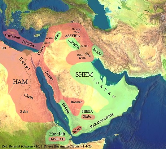
The Middle East through the eyes of the Ancient Israelites. العربية: الشرق الأوسط بعيون الإسرائيليين القدماء. |
| Data | |
| Font |
The background image is based on the satellite image of the Middle East in the public domain from a screenshot from NASA’s globe software World Wind using Blue Marble, Landsat or USGS layer, all of which are in public domain. The geographical location of the place names and color highlights of Ham and Shem are based on the work of 4(four) Israeli Archaeologists: Yohanan Aharoni, Michael Avi-Yonah, Anson F. Rainey, and Ze’ev Safrai, The Macmillan Bible Atlas, Macmillan Publishing: New York, 1993, p. 21. |
| Autor | Hkp-avniel 15:50, 22 March 2008 (UTC) |
| Altres versions | العربيَّة |
Llicència

|
S'autoritza la còpia, la distribució i la modificació d'aquest document sota els termes de la llicència de documentació lliure GNU versió 1.2 o qualsevol altra versió posterior que publiqui la Free Software Foundation; sense seccions invariants, ni textos de portada, ni textos de contraportada. S'inclou una còpia d'aquesta llicència en la secció titulada GNU Free Documentation License. |
- Sou lliure de:
- compartir – copiar, distribuir i comunicar públicament l'obra
- adaptar – fer-ne obres derivades
- Amb les condicions següents:
- reconeixement – Heu de donar la informació adequada sobre l'autor, proporcionar un enllaç a la llicència i indicar si s'han realitzat canvis. Podeu fer-ho amb qualsevol mitjà raonable, però de cap manera no suggereixi que l'autor us dóna suport o aprova l'ús que en feu.
- compartir igual – Si modifiqueu, transformeu, o generareu amb el material, haureu de distribuir les vostres contribucions sota una llicència similar o una de compatible com l'original
Historial del fitxer
Cliqueu una data/hora per veure el fitxer tal com era aleshores.
| Data/hora | Miniatura | Dimensions | Usuari/a | Comentari | |
|---|---|---|---|---|---|
| actual | 17:53, 22 març 2008 | | 1.000 × 895 (823 Ko) | Hkp-avniel | {{Information |Description= |Source= |Date= |Author= |Permission= |other_versions= }} |
| 13:06, 22 març 2008 |  | 1.000 × 895 (825 Ko) | Hkp-avniel | {{Information |Description= The Middle East through the eyes of the Ancient Israelites. |Source= The background image is based on the satellite image of the Middle East in the public domain from a screenshot from NASA’s globe software World Wind using B |
Ús del fitxer
La pàgina següent utilitza aquest fitxer:
Ús global del fitxer
Utilització d'aquest fitxer en altres wikis:
- Utilització a ar.wikipedia.org
- Utilització a bs.wikipedia.org
- Utilització a cs.wikipedia.org
- Utilització a en.wikipedia.org
- Utilització a fi.wikipedia.org
- Utilització a fr.wikipedia.org
- Utilització a he.wikipedia.org
- Utilització a lt.wikipedia.org
- Utilització a pnb.wikipedia.org
- Utilització a pt.wikipedia.org
- Utilització a ro.wikipedia.org
- Utilització a so.wikipedia.org
- Utilització a uk.wikipedia.org
- Utilització a zh.wikipedia.org