
Fitxer:Netherlands during French administration 1810-1814.png

Mida d'aquesta previsualització: 408 × 599 píxels. Altres resolucions: 163 × 240 píxels | 520 × 764 píxels.
Fitxer original (520 × 764 píxels, mida del fitxer: 889 Ko, tipus MIME: image/png)
| Aquest fitxer i la informació mostrada a continuació provenen del dipòsit multimèdia lliure Wikimedia Commons. |
Resum
| Descripció |
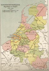
English: Map of Belgium and the Netherlands during the French occupation. Français : Carte de la Belgique et des Pays-Bas pendant l'occupation française. |
||||||||||||||||||||
| Data | abans 1910 | ||||||||||||||||||||
| Font | Scan from Atlas de géographie physique, politique et historique à l'usage de l'enseignement primaire et de l'enseignement moyen, Dessain, Liège, 35e éd., s.d., p. 40. | ||||||||||||||||||||
| Autor |
|
||||||||||||||||||||

Llicència
|
Aquest material està en domini públic als Estats Units i als altres països on el dret d'autor s'estén per 100 anys (o menys) després de la mort de l'autor. Aquesta obra es troba en el domini públic als Estats Units d'Amèrica per haver estat publicada abans de l'1 de gener de 1929. | |
| Aquest fitxer està identificat com a lliure de restriccions conegudes sota la llei de drets d'autor, inclosos els drets veïns. | |
Historial del fitxer
Cliqueu una data/hora per veure el fitxer tal com era aleshores.
| Data/hora | Miniatura | Dimensions | Usuari/a | Comentari | |
|---|---|---|---|---|---|
| actual | 13:16, 31 oct 2005 | | 520 × 764 (889 Ko) | BrightRaven | Map of Belgium and the Netherlands during the French occupation. Author : MG Alexis |
Ús del fitxer
Les 3 pàgines següents utilitzen aquest fitxer:
Ús global del fitxer
Utilització d'aquest fitxer en altres wikis:
- Utilització a ar.wikipedia.org
- Utilització a ast.wikipedia.org
- Utilització a br.wikipedia.org
- Utilització a cs.wikipedia.org
- Utilització a en.wikipedia.org
- Utilització a eo.wikipedia.org
- Utilització a es.wikipedia.org
- Utilització a fr.wikipedia.org
- Utilització a fy.wikipedia.org
- Utilització a gl.wikipedia.org
- Utilització a id.wikipedia.org
- Utilització a it.wikipedia.org
- Utilització a la.wikipedia.org
- Utilització a li.wikipedia.org
- Utilització a mt.wikipedia.org
- Utilització a nl.wikipedia.org
- Utilització a vls.wikipedia.org
- Utilització a zh.wikipedia.org