
Fitxer:SH-60B helicopter flies over Sendai.jpg

Mida d'aquesta previsualització: 800 × 534 píxels. Altres resolucions: 320 × 214 píxels | 640 × 427 píxels | 1.024 × 684 píxels | 1.280 × 855 píxels | 2.763 × 1.845 píxels.
Fitxer original (2.763 × 1.845 píxels, mida del fitxer: 3,78 Mo, tipus MIME: image/jpeg)
| Aquest fitxer i la informació mostrada a continuació provenen del dipòsit multimèdia lliure Wikimedia Commons. |
Resum
| Descripció |
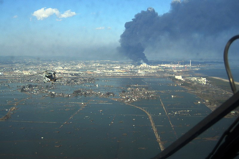
English: An SH-60F helicopter assigned to the Chargers of Helicopter Antisubmarine Squadron (HS) 14 from Naval Air Facility Atsugi flies over the port of Sendai to deliver more than 1,500 pounds of food to survivors of an 9.0 magnitude earthquake and a tsunami (2011 Tōhoku earthquake and tsunami). The citizens of Ebina City, Japan, donated the food, and the U.S. Military provided earthquake and tsunami relief support.
日本語: 海老名市民から寄付された1500ポンド(680kg)の食料を携え、M9.0を記録した東北地方太平洋沖地震被災地の救援に向かう、厚木海軍飛行場・第14対潜ヘリコプター隊(HS-14)「チャージャーズ」のSH-60B(津波で水没した仙台港付近上空)。
한국어: 에비나시 시민들의 기증한 1500 파운드 (680kg) 이상의 식량을 피해자들에게 전달하는 임무에 해당 SH - 60 시호크 (아츠기 해군 비행장 미 해군 제 14 대잠 헬기 비행대)가 촬영한 센다이 항 상공의 사진. 2011 년 동북 지방 태평양 연안 지진 발생 다음날 상황이다 |
|||
| Data | ||||
| Font |
|
|||
| Autor | U.S. Navy photo | |||
| Altres versions |

.jpg)
| Posició de la càmera | | Aquesta i altres imatges properes a: OpenStreetMap |
|---|
Llicència
Aquesta imatge és obra d'un mariner o empleat de l'U.S. Navy feta durant la prestació oficial de servei. Com a obra del govern federal dels EUA, la imatge és en el domini públic.
|
 | |
| Aquest fitxer està identificat com a lliure de restriccions conegudes sota la llei de drets d'autor, inclosos els drets veïns. | ||
Historial del fitxer
Cliqueu una data/hora per veure el fitxer tal com era aleshores.
| Data/hora | Miniatura | Dimensions | Usuari/a | Comentari | |
|---|---|---|---|---|---|
| actual | 16:15, 16 març 2011 | | 2.763 × 1.845 (3,78 Mo) | Citypeek | autorotate |
| 19:21, 13 març 2011 |  | 2.877 × 1.926 (3,7 Mo) | BurtAlert | {{Information |Description ={{en|1=An SH-60B helicopter assigned to the Chargers of Helicopter Antisubmarine Squadron (HS) 14 from Naval Air Facility Atsugi flies over the city of Sendai to deliver more than 1,500 pounds of food to survivors of an 8.9 |
Ús del fitxer
Les 4 pàgines següents utilitzen aquest fitxer:
Ús global del fitxer
Utilització d'aquest fitxer en altres wikis:
- Utilització a ar.wikipedia.org
- Utilització a ar.wikinews.org
- Utilització a ast.wikipedia.org
- Utilització a as.wikipedia.org
- Utilització a azb.wikipedia.org
- Utilització a az.wikipedia.org
- Utilització a ba.wikipedia.org
- Utilització a bcl.wikipedia.org
- Utilització a bg.wikipedia.org
- Utilització a bn.wikipedia.org
- Utilització a ckb.wikipedia.org
- Utilització a cs.wikipedia.org
- Utilització a cy.wikipedia.org
- Utilització a de.wikipedia.org
- Utilització a el.wikipedia.org
- Utilització a el.wikinews.org
- Utilització a en.wikipedia.org
- Geography of Japan
- Sendai
- Portal:Japan
- Lists of disasters
- List of earthquakes in Japan
- HSC-14
- 2011 in politics
- 2011 Tōhoku earthquake and tsunami
- User:Bencana Tsunami
- User:Bencana Tsunami/sandbox
- Devil Survivor 2: The Animation
- User:ThatGuyJabbles/sandbox
- User:Daniel Mietchen/gallery
- Portal:Tsunamis
- User:Ayane Fumihiro
- User:The ganymedian/sandbox
- Utilització a en.wikinews.org
- 8.9 magnitude earthquake hits Japan, causes tsunami
- Death toll rises from Japan quake
- Japan facing 'most severe crisis since World War II', says prime minister
- Japan earthquake shifts Earth's axis 10 centimetres
- Template:2011 Sendai earthquake and tsunami
- Japan earthquake death toll estimated at over 10,000
- Third explosion at Fukushima Daiichi nuclear power plant
- Fukushima reactor suffers multiple fires, radiation leak confirmed
- In pictures: Japan earthquake and tsunami
- Japan begins using helicopters to drop water on nuclear plant
- Japanese earthquake death toll surpasses ten thousand
Vegeu més usos globals d'aquest fitxer.