
Fitxer:SatVogelfluglinie-R.jpg

Mida d'aquesta previsualització: 800 × 590 píxels. Altres resolucions: 320 × 236 píxels | 640 × 472 píxels | 1.024 × 755 píxels | 1.280 × 944 píxels.
Fitxer original (1.280 × 944 píxels, mida del fitxer: 225 Ko, tipus MIME: image/jpeg)
| Aquest fitxer i la informació mostrada a continuació provenen del dipòsit multimèdia lliure Wikimedia Commons. |
Resum
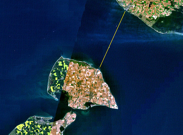
| Descripció |
Deutsch: Satellitenaufnahme Vogelfluglinie Fehmarn – Dänemark (Puttgarden – Rødby) mit Schiffsroute.
Français : Image satellite Vogelfluglinie Fehmarn – Danemark (Puttgarden – Rødby) avec route maritime.
|
| Font | from Nasa World Wind - Free Satellite Image |
| Autor | Fotografia: NASA |
| This image is in the public domain because it is a screenshot from NASA’s globe software World Wind using a public domain layer, such as Blue Marble, MODIS, Landsat, SRTM, USGS or GLOBE.
|
 |
.jpg)
Historial del fitxer
Cliqueu una data/hora per veure el fitxer tal com era aleshores.
| Data/hora | Miniatura | Dimensions | Usuari/a | Comentari | |
|---|---|---|---|---|---|
| actual | 11:56, 30 des 2005 | | 1.280 × 944 (225 Ko) | Godewind | * Satellitenaufnahme Vogelfluglinie Fehmarn - Dänemark (Puttgarden - Rødby) mit Schiffsroute * from Nasa World Wind - Free Satellite Image {{PD-USGov}} Category:Satellite images of the islands |
Ús del fitxer
La pàgina següent utilitza aquest fitxer:
Ús global del fitxer
Utilització d'aquest fitxer en altres wikis:
- Utilització a az.wikipedia.org
- Utilització a ceb.wikipedia.org
- Utilització a cs.wikipedia.org
- Utilització a de.wikipedia.org
- Utilització a en.wikipedia.org
- Utilització a eo.wikipedia.org
- Utilització a es.wikipedia.org
- Utilització a et.wikipedia.org
- Utilització a fi.wikipedia.org
- Utilització a hu.wikipedia.org
- Utilització a it.wikipedia.org
- Utilització a ku.wikipedia.org
- Utilització a lv.wikipedia.org
- Utilització a nds.wikipedia.org
- Utilització a nl.wikipedia.org
- Utilització a nn.wikipedia.org
- Utilització a no.wikipedia.org
- Utilització a pl.wikipedia.org
- Utilització a pt.wikipedia.org
- Utilització a ru.wikipedia.org
- Utilització a sv.wikipedia.org
- Utilització a uk.wikipedia.org
- Utilització a www.wikidata.org
- Utilització a zh.wikipedia.org