
Fitxer:View from Shafer Trail Road in Canyonlands.jpeg
Mida d'aquesta previsualització: 800 × 477 píxels. Altres resolucions: 320 × 191 píxels | 640 × 382 píxels | 1.024 × 611 píxels | 1.600 × 954 píxels.
Fitxer original (1.600 × 954 píxels, mida del fitxer: 391 Ko, tipus MIME: image/jpeg)
| Aquest fitxer i la informació mostrada a continuació provenen del dipòsit multimèdia lliure Wikimedia Commons. |
Resum
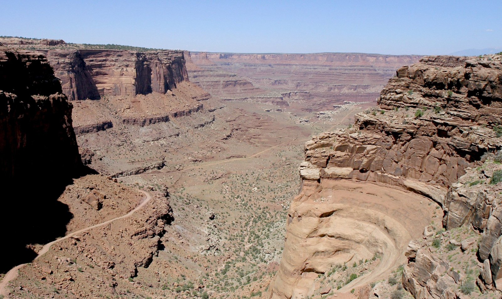
English: Photo taken by Daniel Mayer in late June 2005.
(Note, the photo is High Resolution, expandible). The view is east-northeastwards, toward (unseen) Colorado River region, south side of en:Dead Horse Point State Park, Shafer Trail (road), in Shafer Canyon region-(northeast Canyonlands National Park). The photo is taken from upper cliff, "bedded-cliff" of en:Kayenta Formation, above and in contact with the vertical-cliff of en:Wingate Sandstone.
The upper canyon is in close-up, with Shafer Trail descending to right, and skirting 3-Points, on the white en:White Rim Sandstone shelf-(overlooking the Lower Canyon, in the photo distance). There are many geologic units (in view) below the white shelf, in the distant canyon view. (see sequence, Canyonlands strat: File:Canyonlands strat.jpg). Some of the sequence visible below the White Rim Sandstone:
- Organ Rock Formation (bedded)
- Cedar Mesa Sandstone
- Elephant Canyon Formation & Halgaito Formation (slopes)
- Honaker Trail, Paradox, & Pinkerton Trail Formations
Above the White Rim Sandstone platform (shelf), and below the vertical-cliffs of the en:Wingate Sandstone-(this is in close view-(also distant view), Shafer Trail descending through it), are 8-units: from Wingate: 3-subunits (en:Chinle Formation-(only 3 units in Canyonlands)-(many states, AZ, NM, UT, CO, etc?), 4-subunits of en:Moenkopi Formation-many states-(north border AZ), and Black Box Dolomite (visible?).
The 8-subunits are:
- 3-(Chinle)-Church Rock Member
- 2-(Chinle)-Moss Back Conglomerate
- 1-(Chinle)-Temple Mountain Member
- 4 & 3-(Moenkopi)-Moody Canyon Member and Torrey Member
- 2-(Moenkopi)-Sinbad Limestone
- 1-(Moenkopi)-Black Dragon Member
- Black Box Dolomite
Llicència
Jo, el titular dels drets d'autor d'aquest treball, el public sota la següent llicència:
Aquest fitxer està publicat sota la llicència de Creative Commons Reconeixement i Compartir Igual 2.5 Genèrica.
- Sou lliure de:
- compartir – copiar, distribuir i comunicar públicament l'obra
- adaptar – fer-ne obres derivades
- Amb les condicions següents:
- reconeixement – Heu de donar la informació adequada sobre l'autor, proporcionar un enllaç a la llicència i indicar si s'han realitzat canvis. Podeu fer-ho amb qualsevol mitjà raonable, però de cap manera no suggereixi que l'autor us dóna suport o aprova l'ús que en feu.
- compartir igual – Si modifiqueu, transformeu, o generareu amb el material, haureu de distribuir les vostres contribucions sota una llicència similar o una de compatible com l'original
Historial del fitxer
Cliqueu una data/hora per veure el fitxer tal com era aleshores.
| Data/hora | Miniatura | Dimensions | Usuari/a | Comentari | |
|---|---|---|---|---|---|
| actual | 02:04, 15 març 2006 | | 1.600 × 954 (391 Ko) | Mav | == Summary == Photo taken by Daniel Mayer in late June 2005. == Licensing == {{self|cc-by-sa-2.5}} category:Canyonlands National Park |
Ús del fitxer
La pàgina següent utilitza aquest fitxer:
Ús global del fitxer
Utilització d'aquest fitxer en altres wikis:
- Utilització a fr.wikipedia.org