
Fitxer:West Midlands UK district map (blank).svg

Mida d'aquesta previsualització PNG del fitxer SVG: 800 × 547 píxels. Altres resolucions: 320 × 219 píxels | 640 × 437 píxels | 1.024 × 700 píxels | 1.280 × 875 píxels | 2.560 × 1.750 píxels | 1.425 × 974 píxels.
Fitxer original (fitxer SVG, nominalment 1.425 × 974 píxels, mida del fitxer: 720 Ko)
| Aquest fitxer i la informació mostrada a continuació provenen del dipòsit multimèdia lliure Wikimedia Commons. |
.svg?uselang=ca)
| Descripció |
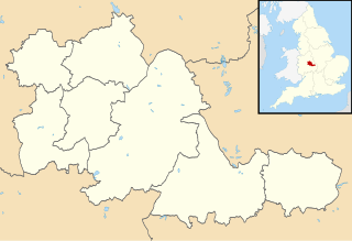
Map of the West Midlands, UK with districts shown. Equirectangular map projection on WGS 84 datum, with N/S stretched 160% Geographic limits:
|
| Data | |
| Font | Ordnance Survey OpenData. Most data from Boundary-Line product. Lake data from Meridian 2 product. Inset derived from England location map.svg by Spischot. |
| Autor | Nilfanion, created using Ordnance Survey data |
| Permís (Com reutilitzar aquest fitxer) |
Aquest fitxer està subjecte a la llicència de Creative Commons Reconeixement i Compartir Igual 3.0 No adaptada. Reconeixement: Contains Ordnance Survey data © Crown copyright and database right
|
| Anotacions | Aquesta imatge té anotacions: Vegeu-les a Commons |
.svg)
Historial del fitxer
Cliqueu una data/hora per veure el fitxer tal com era aleshores.
| Data/hora | Miniatura | Dimensions | Usuari/a | Comentari | |
|---|---|---|---|---|---|
| actual | 10:21, 22 ago 2010 | | 1.425 × 974 (720 Ko) | Nilfanion | +inset, water colour tweak |
| 01:58, 17 jul 2010 |  | 1.425 × 974 (366 Ko) | Nilfanion | {{Information |Description=Map of the West Midlands, UK with districts shown. Equirectangular map projection on WGS 84 datum, with N/S stretched 160% Geographic limits: *West: 2.22W *East: 1.40W *North: 52.68N *South: 52.33N |Source= |
Ús del fitxer
Les 2 pàgines següents utilitzen aquest fitxer:
Ús global del fitxer
Utilització d'aquest fitxer en altres wikis:
- Utilització a ast.wikipedia.org
- Utilització a de.wikipedia.org
- Villa Park
- Birmingham Airport
- Stourbridge
- Coventry Building Society Arena
- St. Andrew’s Stadium
- The Hawthorns
- Molineux Stadium
- Bescot Stadium
- Vorlage:Positionskarte England West Midlands
- Utilita Arena Birmingham
- Meriden (West Midlands)
- SkyDome Arena
- New Cross Hospital
- Alexander Stadium
- Resorts World Arena
- Utilització a en.wikipedia.org
- Utilització a es.wikipedia.org
.svg)