
Fitxer:Aerial view of Matsumoto Castle.jpg

Mida d'aquesta previsualització: 595 × 599 píxels. Altres resolucions: 238 × 240 píxels | 477 × 480 píxels | 762 × 768 píxels | 1.098 × 1.106 píxels.
Fitxer original (1.098 × 1.106 píxels, mida del fitxer: 1,92 Mo, tipus MIME: image/jpeg)
| Aquest fitxer i la informació mostrada a continuació provenen del dipòsit multimèdia lliure Wikimedia Commons. |
Resum
| Descripció |
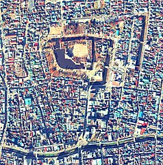
日本語: 松本城上空の空中写真。国土交通省の空中写真ccb-75-15_c8_11から作成。 |
| Data | |
| Font | 国土情報ウェブマッピングシステム |
| Autor | 国土交通省 |
| Posició de la càmera | | Aquesta i altres imatges properes a: OpenStreetMap |
|---|
Llicència

|
El titular dels drets d'autor d'aquest arxiu, the Ministry of Land, Infrastructure, Transport and Tourism of Japan, permet que qualsevol pugui usar-lo per a qualsevol propòsit, sempre que el titular dels drets d'autor sigui reconegut correctament. La redistribució, les obres derivades, l'ús comercial, i qualsevol altre ús està permès. |
Reconeixement:
Copyright © National Land Image Information (Color Aerial Photographs), Ministry of Land, Infrastructure, Transport and Tourism
|
 |
This image is copyrighted by the Ministry of Land, Infrastructure, Transport and Tourism of Japan. For terms of use, see the stipulation to use of National Land Information (in Japanese) and message from MLIT (in Japanese and English). When you display this image on an article, include the following phrase in the description: "Made based on National Land Image Information (Color Aerial Photographs), Ministry of Land, Infrastructure, Transport and Tourism".
|
Historial del fitxer
Cliqueu una data/hora per veure el fitxer tal com era aleshores.
| Data/hora | Miniatura | Dimensions | Usuari/a | Comentari | |
|---|---|---|---|---|---|
| actual | 15:44, 6 oct 2020 | | 1.098 × 1.106 (1,92 Mo) | 名古屋太郎 | 画質修正、EXIFデータ修正 |
| 13:47, 6 març 2014 |  | 1.088 × 1.096 (996 Ko) | 名古屋太郎 | {{Information |Description ={{ja|1=松本城上空の空中写真。国土交通省の空中写真ccb-75-15_c8_11から作成。}} |Source =国土情報ウェブマッピングシステム |Author =国土交通省 |Date =19... |
Ús del fitxer
La pàgina següent utilitza aquest fitxer:
Ús global del fitxer
Utilització d'aquest fitxer en altres wikis: