
Fitxer:Conical mound in trough on Mars' north pole.jpg

Fitxer original (1.734 × 1.188 píxels, mida del fitxer: 1,23 Mo, tipus MIME: image/jpeg)
| Aquest fitxer i la informació mostrada a continuació provenen del dipòsit multimèdia lliure Wikimedia Commons. |
Resum
| Descripció |
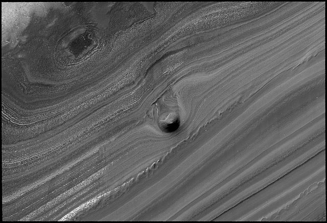
English: This striking image of a mound within the area of a trough cutting into Mars' north polar layered deposits was taken by the High Resolution Imaging Science Experiment (HiRISE) camera on NASA's Mars Reconnaissance Orbiter on September 2, 2008.
The north polar layered deposits are a stack of discernible layers that are rich in water-ice. The stack is up to several miles thick. Each layer is thought to contain information about the climate that existed when it was deposited. If true, the stack could represent a record of how climate has varied on Mars in the recent past. The internal layers are exposed in troughs and scarps where erosion has cut into the stack. The trough shown in this image contains a 1,640-foot thick section of the layering. A conical mound partway down the slope stands approximately 130 feet high. One possible explanation for this unusual mound is that it may be the remnant of a buried impact crater now being exhumed. As the north polar layered deposits accumulated, impacts occurred throughout their surface area, then the impact craters were buried by additional ice. These buried craters are generally inaccessible, but, in a few locations, erosion that forms a trough (like this one) can uncover these buried structures. For reasons poorly understood, the ice beneath the site of the crater is more resistant to this erosion, so when material is removed by erosion the ice beneath the old impact site remains, forming this isolated hill. |
| Data | |
| Font | NASA website; description,[1] high resolution image.[2] |
| Autor | NASA/JPL-Caltech/University of Arizona |
![[2]](http://www.nasa.gov/images/content/283447main_PIA11231_full.jpg)
| Això és una imatge retocada, cosa que vol dir que ha estat alterada digitalment de la seva versió original. Modificacions: Rotated source image.
|
Llicència
| Aquest fitxer és en el domini públic perquè ha estat creat per la NASA. L'avís legal de la NASA diu que «el material de la NASA no està protegit per copyright si no es diu el contrari». (NASA copyright policy page o JPL Image Use Policy). | ||
 |
Atenció:
|
Historial del fitxer
Cliqueu una data/hora per veure el fitxer tal com era aleshores.
| Data/hora | Miniatura | Dimensions | Usuari/a | Comentari | |
|---|---|---|---|---|---|
| actual | 13:31, 28 oct 2008 | | 1.734 × 1.188 (1,23 Mo) | Elipongo | {{Information |Description={{en|1=This striking image of a mound within the area of a trough cutting into Mars' north polar layered deposits was taken by the High Resolution Imaging Science Experiment (HiRISE) camera on NASA's [[Mars Reconnaissance Or |
Ús del fitxer
Les 2 pàgines següents utilitzen aquest fitxer:
Ús global del fitxer
Utilització d'aquest fitxer en altres wikis:
- Utilització a de.wikipedia.org
- Utilització a en.wikipedia.org
- Utilització a es.wikipedia.org
- Utilització a lb.wikipedia.org
- Utilització a pnb.wikipedia.org
- Utilització a tr.wikipedia.org
- Utilització a ur.wikipedia.org
- Utilització a zh.wikipedia.org