
Fitxer:Conquest mexico 1519 21.png

Mida d'aquesta previsualització: 800 × 399 píxels. Altres resolucions: 320 × 160 píxels | 640 × 320 píxels | 1.300 × 649 píxels.
Fitxer original (1.300 × 649 píxels, mida del fitxer: 1,45 Mo, tipus MIME: image/png)
| Aquest fitxer i la informació mostrada a continuació provenen del dipòsit multimèdia lliure Wikimedia Commons. |
Resum

|
Aquest fitxer ha estat substituït per File:Ruta de Cortés.svg. Es recomana utilitzar l'altre. Tingueu en compte que per suprimir imatges substituïdes cal consens. Motiu: "The source of that other map is more recent and reliable."
|
| Descripció |
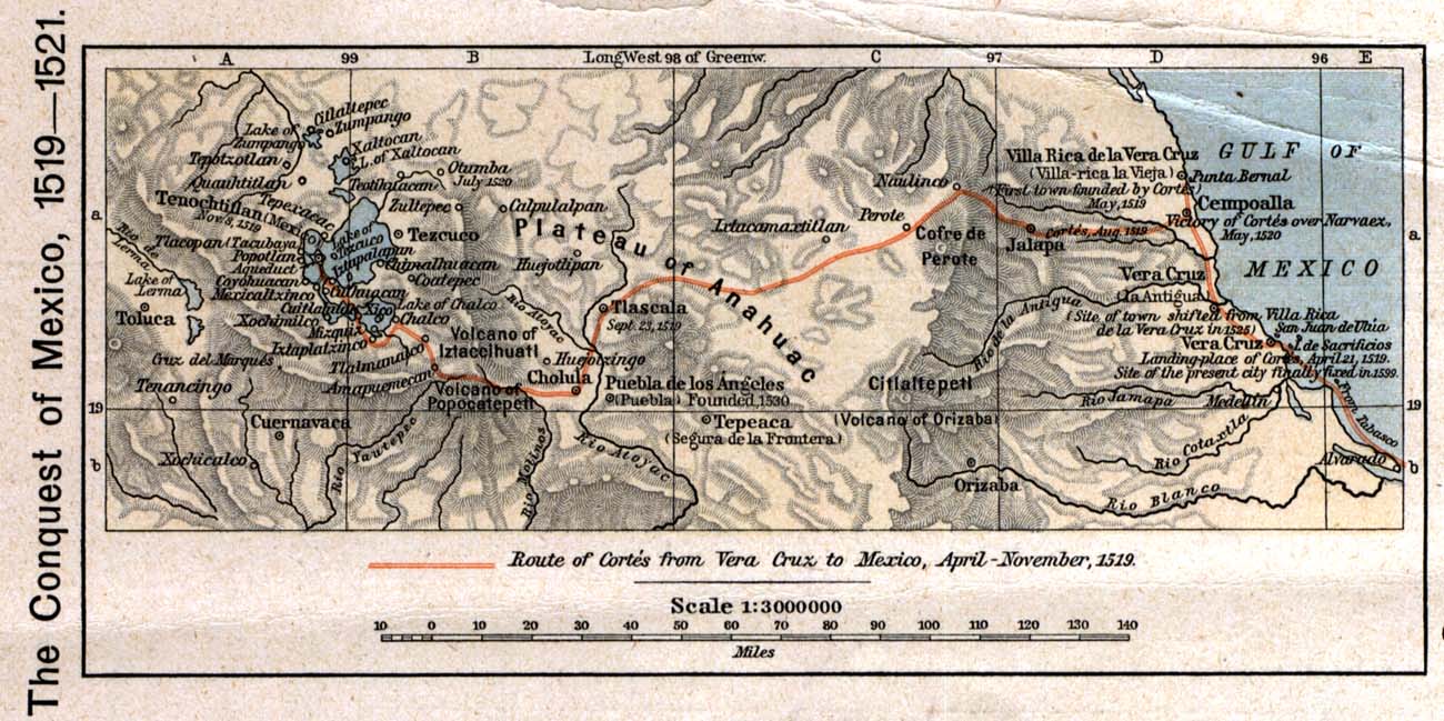
English: The 1519 to 1521 route of the Spanish conquest of the Aztec Empire — taken in Central Mexico by Hernando Cortés.
Français : La route de la conquête espagnole de l'Empire aztèque au centre de Mexique, comme suivi par Hernán Cortés de 1519 à 1521 |
| Data | |
| Font |
English: Scan from Historical Atlas by William R. Shepherd, New York, Henry Holt and Company, 1926 ed. Original image at the Perry-Castañeda Library Map Collection at the en:University of Texas at Austin website: http://www.lib.utexas.edu/maps/historical/shepherd/conquest_mexico_1519_21.jpg |
| Autor | William R. Shepherd |
| Permís (Com reutilitzar aquest fitxer) |
English: From the FAQ @ http://www.lib.utexas.edu/maps/faq.html
|
| Altres versions |
|

Llicència
This file may not have the correct information on its copyright status.
Notify the uploader with:
Items tagged with this template are sorted into Category:Items with disputed copyright information.
|
Aquest fitxer és en el domini públic en els Estats Units. Això és aplicable a obres dels EUA on el copyright ha expirat, sovint perquè la seva primera publicació va ser abans de l'1 de gener de 1929. Vegeu aquesta pàgina per a més detalls.
|
 | |
 |
Podria ser que aquesta imatge no estigui en el domini públic fora dels Estats Units (especialment on no s'aplica la regla del termini més curt per obres dels EUA, com Canada, la Xina continental (no a Hong Kong ni Macau), Alemanya, Mèxic i Suïssa). El creador i any de publicació són informació essencial i s'han de proporcionar. Vegeu Viquipèdia:Drets d'autor per a més detalls.
|
Registre original de càrregues
La pàgina de descripció original era aquí. Els noms d'usuari a continuació es refereixen a en.wikipedia.
- 2006-12-18 21:20 Jengod 1300×649×8 (1520705 bytes) Scan from "Historical Atlas" by William R. Shepherd, New York, Henry Holt and Company, 1926 ed. Original image at the [http://www.lib.utexas.edu/maps/ Perry-Castañeda Library Map Collection] at the [[University of Texas at Austin]] website: http://www.l
Historial del fitxer
Cliqueu una data/hora per veure el fitxer tal com era aleshores.
| Data/hora | Miniatura | Dimensions | Usuari/a | Comentari | |
|---|---|---|---|---|---|
| actual | 22:12, 17 abr 2008 | | 1.300 × 649 (1,45 Mo) | File Upload Bot (Magnus Manske) | {{BotMoveToCommons|en.wikipedia}} {{Information |Description={{en|Scan from "Historical Atlas" by William R. Shepherd, New York, Henry Holt and Company, 1926 ed. Original image at the [http://www.lib.utexas.edu/maps/ Perry-Castañeda Library Map Collect |
Ús del fitxer
La pàgina següent utilitza aquest fitxer:
Ús global del fitxer
Utilització d'aquest fitxer en altres wikis:
- Utilització a azb.wikipedia.org
- Utilització a cs.wikipedia.org
- Utilització a en.wikipedia.org
- Utilització a es.wikipedia.org
- Utilització a fa.wikipedia.org
- Utilització a ja.wikipedia.org
- Utilització a ms.wikipedia.org
- Utilització a pnb.wikipedia.org
- Utilització a sl.wikipedia.org
- Utilització a th.wikipedia.org
- Utilització a tr.wikipedia.org
- Utilització a uk.wikipedia.org
- Utilització a ur.wikipedia.org
- Utilització a vi.wikipedia.org
- Utilització a www.wikidata.org