
Fitxer:Map of Land Ceded by Treaty of Fort Jackson.png
No hi ha cap versió amb una resolució més gran.
Map_of_Land_Ceded_by_Treaty_of_Fort_Jackson.png (320 × 336 píxels, mida del fitxer: 25 Ko, tipus MIME: image/png)
| Aquest fitxer i la informació mostrada a continuació provenen del dipòsit multimèdia lliure Wikimedia Commons. |

|
Aquesta imatge (de tipus mapa) s'hauria de tornar a crear utilitzant gràfics vectorials com ara un fitxer SVG. Això té diversos avantatges; en trobareu més informació a Commons:Media for cleanup. Si ja disposeu d'una versió d'aquesta imatge en format SVG, us preguem que la pengeu; després, reemplaceu aquesta plantilla amb la plantilla {{Vector version available|nom nou de la imatge.svg}} en aquesta imatge.
|
Resum
| Descripció |
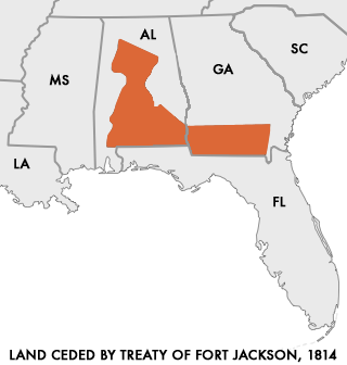
English: Map of Land Ceded to the United States by the warring Creek Nations in the Treaty of Fort Jackson of 1814.
User:Dystopos created this map using as reference a map "Creek Land Cessions Map 1733 through 1832" from the Horseshoe Bend National Military Park page on Areaparks.com [1] Polski: Mapa ziem scedowanych na rzecz USA przez Naród Krików na mocy Traktatu z Fort Jackson z 1814 roku |
| Data | (upload to english Wikipedia) |
| Font | http://en.wikipedia.org/wiki/Image:Map_of_Land_Ceded_by_Treaty_of_Fort_Jackson.png |
| Autor | User:Dystopos |
| Permís (Com reutilitzar aquest fitxer) |
No Rights Reserved |
Llicència
| S'ha alliberat aquesta obra al domini públic pel seu autor Dystopos. Això s'aplica a tot el món. En alguns països això pot no ser legalment possible, en tal cas: |
Historial del fitxer
Cliqueu una data/hora per veure el fitxer tal com era aleshores.
| Data/hora | Miniatura | Dimensions | Usuari/a | Comentari | |
|---|---|---|---|---|---|
| actual | 16:48, 28 març 2006 | | 320 × 336 (25 Ko) | Cień | {{Information| |Description=Map of Land Ceded to the United States by the warring Creek Nations in the Treaty of Fort Jackson of 1814. I created this map using as reference a map "Creek Land Cessions Map 1733 through 1832" from the Horseshoe Bend |
Ús del fitxer
Les 3 pàgines següents utilitzen aquest fitxer:
Ús global del fitxer
Utilització d'aquest fitxer en altres wikis:
- Utilització a ar.wikipedia.org
- Utilització a be.wikipedia.org
- Utilització a da.wikipedia.org
- Utilització a de.wikipedia.org
- Utilització a en.wikipedia.org
- Utilització a es.wikipedia.org
- Utilització a fi.wikipedia.org
- Utilització a fr.wikipedia.org
- Utilització a it.wikipedia.org
- Utilització a ja.wikipedia.org
- Utilització a pl.wikipedia.org
- Utilització a pt.wikipedia.org
- Utilització a ro.wikipedia.org
- Utilització a ru.wikipedia.org
- Utilització a sr.wikipedia.org
- Utilització a sv.wikipedia.org
- Utilització a tr.wikipedia.org
- Utilització a vi.wikipedia.org
- Utilització a www.wikidata.org
- Utilització a zh.wikipedia.org