
Fitxer:Okterritory.png

Mida d'aquesta previsualització: 800 × 477 píxels. Altres resolucions: 320 × 191 píxels | 640 × 382 píxels | 1.024 × 611 píxels | 1.280 × 763 píxels | 2.515 × 1.500 píxels.
Fitxer original (2.515 × 1.500 píxels, mida del fitxer: 534 Ko, tipus MIME: image/png)
| Aquest fitxer i la informació mostrada a continuació provenen del dipòsit multimèdia lliure Wikimedia Commons. |

|
Aquesta imatge (de tipus locator map) s'hauria de tornar a crear utilitzant gràfics vectorials com ara un fitxer SVG. Això té diversos avantatges; en trobareu més informació a Commons:Media for cleanup. Si ja disposeu d'una versió d'aquesta imatge en format SVG, us preguem que la pengeu; després, reemplaceu aquesta plantilla amb la plantilla {{Vector version available|nom nou de la imatge.svg}} en aquesta imatge.
|
Resum
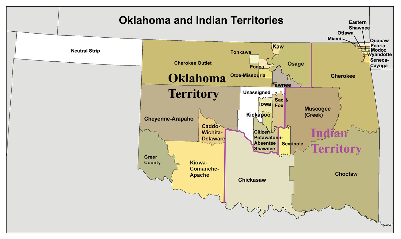
English: A map of the Oklahoma Territory and the reduced Indian Territory circa 1890's.
- In present day Oklahoma.
- Credits
- I made this using Census Bureau data and this 1892 map as a reference.
Llicència
Jo, el titular dels drets d'autor d'aquest treball, el public sota la següent llicència:
Aquest fitxer està subjecte a la llicència de Creative Commons Reconeixement i Compartir Igual 3.0 No adaptada.
- Sou lliure de:
- compartir – copiar, distribuir i comunicar públicament l'obra
- adaptar – fer-ne obres derivades
- Amb les condicions següents:
- reconeixement – Heu de donar la informació adequada sobre l'autor, proporcionar un enllaç a la llicència i indicar si s'han realitzat canvis. Podeu fer-ho amb qualsevol mitjà raonable, però de cap manera no suggereixi que l'autor us dóna suport o aprova l'ús que en feu.
- compartir igual – Si modifiqueu, transformeu, o generareu amb el material, haureu de distribuir les vostres contribucions sota una llicència similar o una de compatible com l'original
Historial del fitxer
Cliqueu una data/hora per veure el fitxer tal com era aleshores.
| Data/hora | Miniatura | Dimensions | Usuari/a | Comentari | |
|---|---|---|---|---|---|
| actual | 18:34, 20 gen 2010 | | 2.515 × 1.500 (534 Ko) | Kmusser | spelling correction |
| 17:10, 20 gen 2010 |  | 2.551 × 1.500 (557 Ko) | Kmusser | increased resolution | |
| 20:02, 31 jul 2006 |  | 600 × 358 (33 Ko) | Kmusser | == Summary == This is a map of Oklahoma and Indian Territory circa 1890's that I made using and Census Bureau data and [http://hdl.loc.gov/loc.gmd/g4021e.ct000224 this |
Ús del fitxer
Les 23 pàgines següents utilitzen aquest fitxer:
- Apatxe kiowa
- Caddos
- Chickasaw (grup humà)
- Choctaws
- Cinc tribus civilitzades
- Comtat de Beaver (Oklahoma)
- Comtat de Cimarron
- Districte Apukshunnubbee
- Districte Moshulatubbee
- Districte Pushmataha
- Estat de Sequoyah
- Indian Intercourse Act
- Llei Orgànica d'Oklahoma
- Nació Chickasaw
- Nació Choctaw d'Oklahoma
- Nació Muscogee
- Nació Seminola d'Oklahoma
- Oklahoma Panhandle
- Osages
- Territori Indi
- Tonkawes
- Wichita (poble)
- Plantilla:Territori Indi
Ús global del fitxer
Utilització d'aquest fitxer en altres wikis:
- Utilització a af.wikipedia.org
- Utilització a ar.wikipedia.org
- Utilització a arz.wikipedia.org
- Utilització a bcl.wikipedia.org
- Utilització a bn.wikipedia.org
- Utilització a chr.wikipedia.org
- Utilització a chy.wikipedia.org
- Utilització a cy.wikipedia.org
- Utilització a de.wikipedia.org
- 16. November
- 23. März
- 1890
- Indianerpolitik der Vereinigten Staaten
- Indianerterritorium
- Pfad der Tränen
- Osage
- Oklahoma Land Run
- Sequoyah (Staat)
- Oklahoma-Territorium
- Oklahoma Panhandle
- Standing Bear (Ponca)
- Cherokee Freedmen
- Indian Appropriations Act (1885)
- Oklahoma Enabling Act
- Osage Allotment Act
- Oklahoma Land Run (1889)
- Cherokee Outlet
- Utilització a en.wikipedia.org
- Stringtown, Oklahoma
- Commerce, Oklahoma
- Historical regions of the United States
- State of Sequoyah
- Oklahoma panhandle
- Osage Nation
- User:Kmusser/Images
- Portal:Oklahoma
- History of Oklahoma
- Northwestern Oklahoma
- Socialist Party of Oklahoma
- Oklahoma Territorial Legislature
- Cherokee Nation (1794–1907)
- Cherokee Commission
- Oklahoma Organic Act
- United States v. Ramsey (1926)
- Treaty of the Wabash
- User:Joelton Ivson/Gather lists/24319 – Indígenas América do Norte
- Atoka County, Choctaw Nation
- Utilització a eo.wikipedia.org
- Utilització a es.wikipedia.org
Vegeu més usos globals d'aquest fitxer.