
Fitxer:1814ThompsonMap.jpg
Fitxer original (4.020 × 2.593 píxels, mida del fitxer: 3,83 Mo, tipus MIME: image/jpeg)
| Aquest fitxer i la informació mostrada a continuació provenen del dipòsit multimèdia lliure Wikimedia Commons. |
Resum
| Descripció |
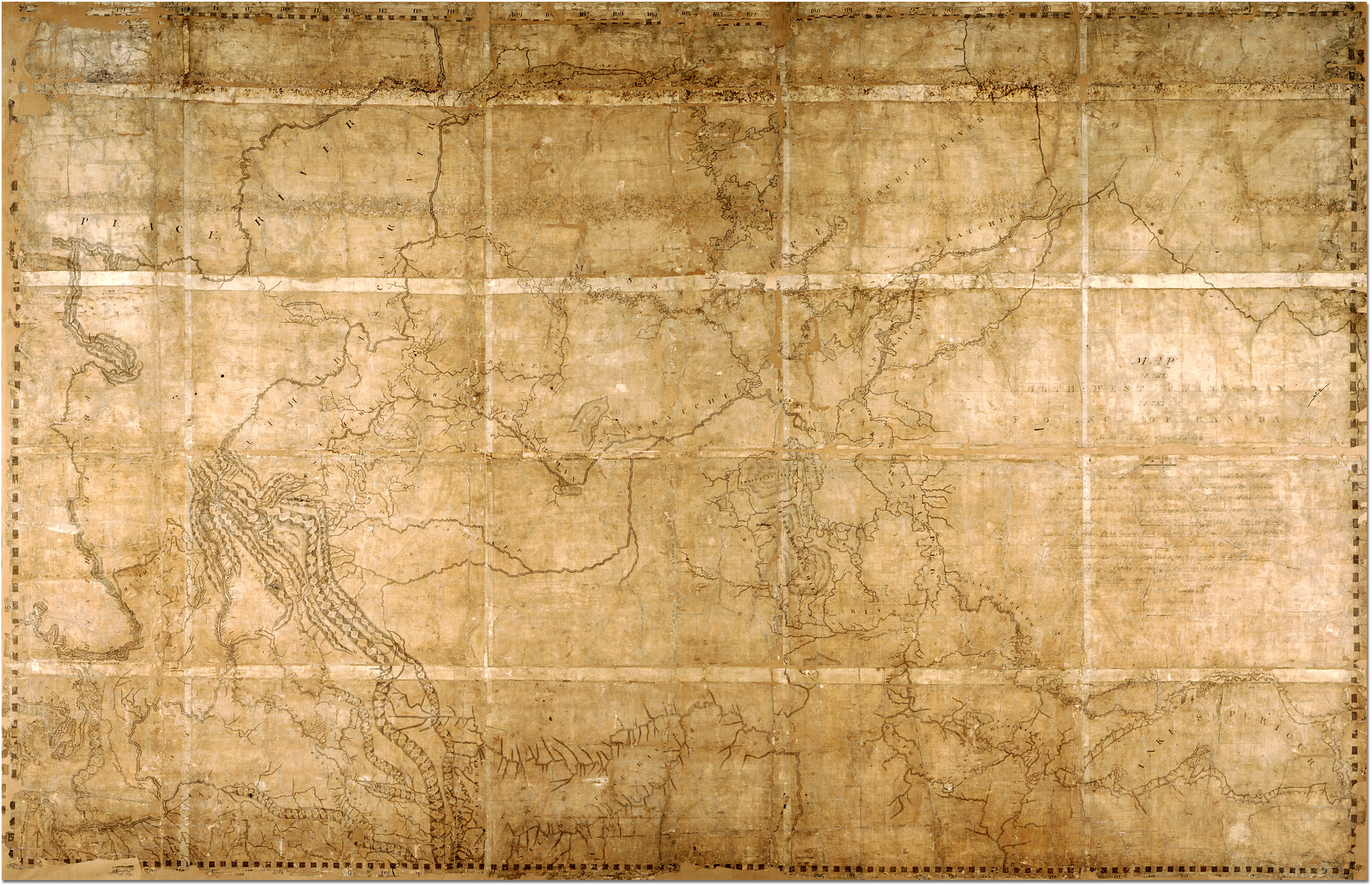
English: Map of the North-West Territory of the Province of Canada by David Thompson, 1814 Archives of Ontario, I0012850 Map is in the public domain. See:http://ao.minisisinc.com/scripts/mwimain.dll/144/ARCH_DESC_FACT/FACTSDESC/REFD%2BF%2B443-6?SESSIONSEARCH Full Title: "Map of the North-West Territory of the Province of Canada from actual Survey during the years 1792-1812. This map made for the North West Company in 1813 and 1814 and delivered to the Honorable William McGillivray then agent Embraces the Region lying between 45 and 60 degrees North Latitude and 84 and 124 degrees West Longitude comprising the Survey's and Discoveries of 20 years namely the Discovery and Survey of the Oregon Territory to the Pacific Ocean the Survey of the Athabasca Lake Slave River and Lake from which flows Mackenzie's River to the Arctic Sea by Mr. Philip Turner the Route of Alexander Mackenzie in 1792 down part of Fraser's river together with the Survey of this River to the Pacific Ocean by the late John Stuart of the North-West Company by David Thompson Astronomer and Surveyor." |
| Data | entre 1813 i 1814 |
| Font | https://aims.archives.gov.on.ca/scripts/mwimain.dll/144/DESCRIPTION_WEB/WEB_DESC_DET?SESSIONSEARCH&exp=sisn%2013129 |
| Autor | David Thompson |
Resum ==

|
This image is available from the Archives of Ontario under the item reference code F 443, R-C(U), AO 1541 This tag does not indicate the copyright status of the attached work. A normal copyright tag is still required. See Commons:Licensing. |
Llicència ==
|
Aquest material està en domini públic als Estats Units i als altres països on el dret d'autor s'estén per 70 anys (o menys) després de la mort de l'autor.
| |
| Aquest fitxer està identificat com a lliure de restriccions conegudes sota la llei de drets d'autor, inclosos els drets veïns. | |
Historial del fitxer
Cliqueu una data/hora per veure el fitxer tal com era aleshores.
| Data/hora | Miniatura | Dimensions | Usuari/a | Comentari | |
|---|---|---|---|---|---|
| actual | 23:41, 7 feb 2007 | | 4.020 × 2.593 (3,83 Mo) | Ccscott~commonswiki | Map of the North-West Territory of the Province of Canada by David Thompson, 1814 Reference Code: F 443, R-C(U), AO 1541 Archives of Ontario, I0012850 Image URL: http://www.archives.gov.on.ca/english/interloan/big/thompson_mapa.htm Map is in the public d |
Ús del fitxer
La pàgina següent utilitza aquest fitxer:
Ús global del fitxer
Utilització d'aquest fitxer en altres wikis:
- Utilització a ar.wikipedia.org
- Utilització a de.wikipedia.org
- Utilització a en.wikipedia.org
- Utilització a es.wikipedia.org
- Utilització a it.wikipedia.org
- Utilització a ja.wikipedia.org
- Utilització a nl.wikipedia.org
- Utilització a no.wikipedia.org
- Utilització a ru.wikipedia.org