
Fitxer:1857 U.S.C.S. Map of San Diego Bay, California - Geographicus - SanDiegoBay-uscs-1857.jpg

Fitxer original (4.000 × 5.118 píxels, mida del fitxer: 3,62 Mo, tipus MIME: image/jpeg)
| Aquest fitxer i la informació mostrada a continuació provenen del dipòsit multimèdia lliure Wikimedia Commons. |
| San Diego Bay California | ||||||
|---|---|---|---|---|---|---|
| Artista | ||||||
| Títol |
San Diego Bay California |
|||||
| Descripció |
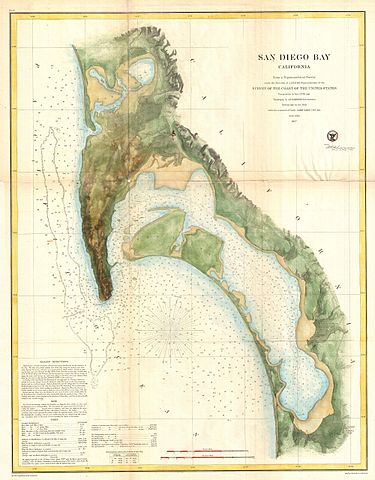
English: This is the most attractive map of San Diego Bay, California, to emerge from the work of the U.S. Coast Survey. Covers the San Diego area from False Bay and the Valley of Las Yeguas southward past Mission Valley and San Diego city to San Diego Bay and the villages of La Punta and the Valley of Ohjia. Offers superb detail both inland and at sea. Inland detail includes topographical features, rivers, roads, and villages. Villages and cities, including San Diego, La Playa, New San Diego, and others, are detailed to the level of individual buildings. Nautical details include innumerable depth sounding, breakwaters, and notes on the Kelp Beds off the coast of Point Loma. Lower left quadrant features textual sailing instructions as well as notes on the tides and a history of the chart. This cart was prepared under the supervision of A. D. Bache for inclusion in the 1857 edition of the Report of the Superintendent of the United States Coast Survey . The triangulation for this chart was accomplished by R. D. Cutts, the topography by A. M. Harrison, and the hydrography by a party under the command of James Alden. |
|||||
| Data | 1857 (dated) | |||||
| Dimensions | altura: 27 in (68,5 cm); amplada: 20,5 in (52 cm) | |||||
| Número d'inventari |
Geographicus link: SanDiegoBay-uscs-1857 |
|||||
| Origen/Fotògraf |
Report of the Superintendant of the United States Coast Survey, Washington, (1857 edition).
|
|||||
| Permís (Com reutilitzar aquest fitxer) |
|
|||||
Historial del fitxer
Cliqueu una data/hora per veure el fitxer tal com era aleshores.
| Data/hora | Miniatura | Dimensions | Usuari/a | Comentari | |
|---|---|---|---|---|---|
| actual | 09:05, 16 març 2011 | | 4.000 × 5.118 (3,62 Mo) | BotMultichill | {{subst:User:Multichill/Geographicus |link=http://www.geographicus.com/P/AntiqueMap/SanDiegoBay-uscs-1857 |product_name=1857 U.S.C.S. Map of San Diego Bay, California |map_title=San Diego Bay California |description=This is the most attractive map of San |
Ús del fitxer
La pàgina següent utilitza aquest fitxer:
Ús global del fitxer
Utilització d'aquest fitxer en altres wikis:
- Utilització a en.wikipedia.org
- Utilització a pl.wikipedia.org
- Utilització a sv.wikipedia.org