
Fitxer:2007 01 23 - Stringtown@121@355@270 - WB 2.JPG

Mida d'aquesta previsualització: 800 × 600 píxels. Altres resolucions: 320 × 240 píxels | 640 × 480 píxels | 1.024 × 768 píxels | 1.280 × 960 píxels | 2.592 × 1.944 píxels.
Fitxer original (2.592 × 1.944 píxels, mida del fitxer: 1,33 Mo, tipus MIME: image/jpeg)
| Aquest fitxer i la informació mostrada a continuació provenen del dipòsit multimèdia lliure Wikimedia Commons. |
| Descripció |
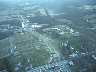
English: Stringtown Road runs from through the center from the bottom to the interchange near the top, where it continues on as MD 121 (Clarksburg Road) to the horizon. MD 121 splits toward the center-right, generally hidden behind trees. These roads interchange with I-270, which runs left to right, toward the top. The left-right roadway at the bottom is MD 355. Clarksburg, MD, USA
|
||||
| Data | |||||
| Font | Treball propi | ||||
| Autor | Andrew Bossi | ||||
| Permís (Com reutilitzar aquest fitxer) |
Own work, share alike, attribution required (Creative Commons CC-BY-SA-2.5) |
Jo, el titular dels drets d'autor d'aquest treball, el public sota la següent llicència:
Aquest fitxer està publicat sota la llicència de Creative Commons Reconeixement i Compartir Igual 2.5 Genèrica.
- Sou lliure de:
- compartir – copiar, distribuir i comunicar públicament l'obra
- adaptar – fer-ne obres derivades
- Amb les condicions següents:
- reconeixement – Heu de donar la informació adequada sobre l'autor, proporcionar un enllaç a la llicència i indicar si s'han realitzat canvis. Podeu fer-ho amb qualsevol mitjà raonable, però de cap manera no suggereixi que l'autor us dóna suport o aprova l'ús que en feu.
- compartir igual – Si modifiqueu, transformeu, o generareu amb el material, haureu de distribuir les vostres contribucions sota una llicència similar o una de compatible com l'original
Historial del fitxer
Cliqueu una data/hora per veure el fitxer tal com era aleshores.
| Data/hora | Miniatura | Dimensions | Usuari/a | Comentari | |
|---|---|---|---|---|---|
| actual | 01:18, 16 nov 2007 | | 2.592 × 1.944 (1,33 Mo) | Thisisbossi | {{Information |Description={{en|Stringtown Road runs from through the center from the bottom to the interchange near the top, where it continues on as MD 121 (Clarksburg Road) to the horizon. MD 121 splits toward the center-right, generally hidden behind |
Ús del fitxer
La pàgina següent utilitza aquest fitxer:
Ús global del fitxer
Utilització d'aquest fitxer en altres wikis:
- Utilització a ar.wikipedia.org
- Utilització a azb.wikipedia.org
- Utilització a ceb.wikipedia.org
- Utilització a en.wikipedia.org
- Utilització a es.wikipedia.org
- Utilització a eu.wikipedia.org
- Utilització a fa.wikipedia.org
- Utilització a it.wikipedia.org
- Utilització a ky.wikipedia.org
- Utilització a lld.wikipedia.org
- Utilització a pl.wikipedia.org
- Utilització a pt.wikipedia.org
- Utilització a sh.wikipedia.org
- Utilització a sr.wikipedia.org
- Utilització a tt.wikipedia.org
- Utilització a uk.wikipedia.org
- Utilització a ur.wikipedia.org
- Utilització a uz.wikipedia.org
- Utilització a www.wikidata.org
- Utilització a zh-min-nan.wikipedia.org
- Utilització a zh.wikipedia.org