Fitxer:Bancdarguin oli 2019362.jpg

El contingut de la pàgina no s'admet en altres llengües.
De la Viquipèdia, l'enciclopèdia lliure

Fitxer original(720 × 700 píxels, mida del fitxer: 372 Ko, tipus MIME: image/jpeg)

Descripció a Commons

Resum

Descripció
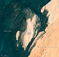
English: When viewed from space, the shoals, seagrass beds, and mudflats of Mauritania’s Banc d'Arguin National Park often blend with sand and sea in beautiful ways.

So it was on December 28, 2019, when the Operational Land Imager (OLI) on Landsat 8 captured this natural-color image of the park’s shallow coastal waters. The mostly barren dunes on the shore drew a contrast with the maze of coastal mudflats (dark brown) and shallow seagrass beds (green) that grow beneath a few meters of water. Deeper channels (dark blue) meander and flow among the sea grass and sandy shoals.

While signs of life are rare on this mostly arid land, the upwelling of cool, nutrient-rich water offshore causes the park’s coastal areas to burst with marine life. Whales, dolphins, and seals all make appearances. Thriving finfish and shellfish populations attract migratory birds to breeding sites here. Expansive tidal mudflats support upwards of 2 million shorebirds, making Banc d'Arguin one of the largest meeting places for Palaearctic birds in the world. Several endangered marine mammals occasionally turn up, notably monk seals and humpback dolphins.

But Landsat does more than deliver an occasional pretty picture. Scientists have analyzed 20 years of satellite observations and found that the park’s extensive seagrass beds have remained remarkably healthy and resilient, despite weathering occasional damage from storms and dust that temporarily killed grasses in certain areas.

NASA Earth Observatory image by Lauren Dauphin, using Landsat data from the U.S. Geological Survey. Caption by Adam Voiland.
Data December 28, 2019 JPEG
Font https://earthobservatory.nasa.gov/images/146600/beautiful-banc-darguin-national-park?src=eoa-iotd
Autor NASA Earth Observatory
Permís
(Com reutilitzar aquest fitxer)
Public domain Aquest fitxer és en el domini públic perquè ha estat creat per la NASA. L'avís legal de la NASA diu que «el material de la NASA no està protegit per copyright si no es diu el contrari». (NASA copyright policy page o JPL Image Use Policy).
Atenció:
  • L'ús dels logotips de la NASA, insígnies i emblemes està restringit la llei dels EUA 14 CFR 1221.
  • El lloc web de la NASA disposa d'un gran nombre d'imatges de l'Agència Espacial Russa, o soviètica, i d'altres agències no nord-americanes. Aquestes imatges no són necessàriament en el domini públic.
  • El material del Telescopi espacial Hubble pot tenir els drets reservats si no prové explícitament del STScI. [1]
  • Tot el material de la sonda SOHO està reservat i requereix d'autorització per a un ús comercial no educatiu. [2]
  • Les imatges destacades en el lloc web Astronomy Picture of the Day (APOD) poden tenir drets d'autor. [3]

Llegendes

Afegeix una explicació d'una línia del que representa aquest fitxer

Elements representats en aquest fitxer

representa l'entitat

381.175 byte

700 píxel

720 píxel

Historial del fitxer

Cliqueu una data/hora per veure el fitxer tal com era aleshores.

Data/horaMiniaturaDimensionsUsuari/aComentari
actual15:53, 23 abr 2020Miniatura per a la versió del 15:53, 23 abr 2020720 × 700 (372 Ko)Tillman{{Information |description ={{en|1=When viewed from space, the shoals, seagrass beds, and mudflats of Mauritania’s Banc d'Arguin National Park often blend with sand and sea in beautiful ways. So it was on December 28, 2019, when the Operational Land Imager (OLI) on Landsat 8 captured this natural-color image of the park’s shallow coastal waters. The mostly barren dunes on the shore drew a contrast with the maze of coastal mudflats (dark brown) and shallow seagrass beds (green) that grow be...

Les 2 pàgines següents utilitzen aquest fitxer:

Ús global del fitxer

Utilització d'aquest fitxer en altres wikis: