
Fitxer:Bulgaria geographic map Rila bg.svg

Mida d'aquesta previsualització PNG del fitxer SVG: 800 × 559 píxels. Altres resolucions: 320 × 224 píxels | 640 × 447 píxels | 1.024 × 715 píxels | 1.280 × 894 píxels | 2.560 × 1.789 píxels | 4.294 × 3.000 píxels.
Fitxer original (fitxer SVG, nominalment 4.294 × 3.000 píxels, mida del fitxer: 14,35 Mo)
| Aquest fitxer i la informació mostrada a continuació provenen del dipòsit multimèdia lliure Wikimedia Commons. |
Resum
| Descripció |
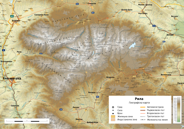
Български: Географска карта на Рила. Карта на български. Граници на картата:
|
| Data | |
| Font |
Treball propi
|
| Autor | Ikonact |
| Permís (Com reutilitzar aquest fitxer) |
Any use of this map is subject of the license(s) stated below with the condition that you credit (Wikimedia Commons user: Ikonact) as the author . A message with a reply address would also be greatly appreciated. |

|
Aquest fitxer SVG inclou text encapsulat que es pot traduir al vostre idioma utilitzant un editor que admeti SVG, un editor de text o l'eina de traducció de SVG. Per a més informació vegeu l'ajuda de traducció de fitxers SVG. |
Aquesta imatge vectorial va ser creada amb Inkscape, i posteriorment modificada manualment
.Llicència
| This work contains information from OpenStreetMap, which is made available under the Open Database License (ODbL).
The ODbL does not require any particular license for maps produced from ODbL data. Prior to 1 August 2020, map tiles produced by the OpenStreetMap Foundation were licensed under the CC-BY-SA-2.0 license. Maps produced by other people may be subject to other licences. |
Jo, el titular dels drets d'autor d'aquest treball, el public sota la següent llicència:
This file is licensed under the Creative Commons Attribution-Share Alike 4.0 International license.
- Sou lliure de:
- compartir – copiar, distribuir i comunicar públicament l'obra
- adaptar – fer-ne obres derivades
- Amb les condicions següents:
- reconeixement – Heu de donar la informació adequada sobre l'autor, proporcionar un enllaç a la llicència i indicar si s'han realitzat canvis. Podeu fer-ho amb qualsevol mitjà raonable, però de cap manera no suggereixi que l'autor us dóna suport o aprova l'ús que en feu.
- compartir igual – Si modifiqueu, transformeu, o generareu amb el material, haureu de distribuir les vostres contribucions sota una llicència similar o una de compatible com l'original
Historial del fitxer
Cliqueu una data/hora per veure el fitxer tal com era aleshores.
| Data/hora | Miniatura | Dimensions | Usuari/a | Comentari | |
|---|---|---|---|---|---|
| actual | 22:20, 3 oct 2018 | | 4.294 × 3.000 (14,35 Mo) | Ikonact | descriptions added |
| 07:54, 3 oct 2018 |  | 4.294 × 3.000 (14,32 Mo) | Ikonact | == {{int:filedesc}} == {{Information |description={{en|1=Geographic map of Rila, Bulgaria in Bulgarian. Geographic limits of the map:}} {{bg|1=Географска карта на Рила. Карта на български. Граници на картата:}} *N: 42.36° N *S: 41.80° N *W: 23.02° E *E: 24.10° E Projection: Equidistant Cylindrical |date=2018-10-03 |source={{own}} *Sources of data:<br/> **Topography: NASA SRTM3 v3; **Rivers: Produced using Copernicus data and information funded by the... |
Ús del fitxer
La pàgina següent utilitza aquest fitxer:
Ús global del fitxer
Utilització d'aquest fitxer en altres wikis:
- Utilització a bg.wikipedia.org
- Utilització a el.wikipedia.org
- Utilització a en.wikipedia.org
- Utilització a es.wikipedia.org
- Utilització a hu.wikipedia.org
- Utilització a mk.wikipedia.org
- Utilització a sl.wikipedia.org
- Utilització a tg.wikipedia.org
- Utilització a www.wikidata.org