
Fitxer:CNF Wilderness Map.jpg

Mida d'aquesta previsualització: 790 × 600 píxels. Altres resolucions: 316 × 240 píxels | 632 × 480 píxels | 1.009 × 766 píxels.
Fitxer original (1.009 × 766 píxels, mida del fitxer: 195 Ko, tipus MIME: image/jpeg)
| Aquest fitxer i la informació mostrada a continuació provenen del dipòsit multimèdia lliure Wikimedia Commons. |
Resum
| Descripció |
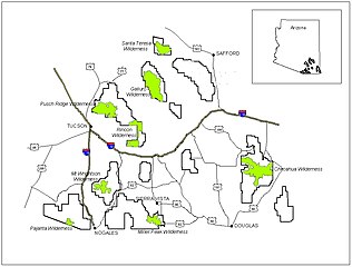
English: Map of designated wilderness areas within the Coronado National Forest of southeastern Arizona. |
|||
| Font | U.S. Forest Service—[1] | |||
| Autor | USFS | |||
| Permís (Com reutilitzar aquest fitxer) |
|
en:Category:Coronado National Forest
Historial del fitxer
Cliqueu una data/hora per veure el fitxer tal com era aleshores.
| Data/hora | Miniatura | Dimensions | Usuari/a | Comentari | |
|---|---|---|---|---|---|
| actual | 01:37, 30 març 2008 | | 1.009 × 766 (195 Ko) | Axcordion~commonswiki | {{Information |Description=Map of designated wilderness areas in the Coronado National Forest of southeast Arizona, USA. |Source=U.S. Forest Service[http://www.fs.fed.us/r3/coronado/forest/recreation/wilderness/wilderness_map.shtml] |Date= |Author=USFS |P |
Ús del fitxer
La pàgina següent utilitza aquest fitxer:
Ús global del fitxer
Utilització d'aquest fitxer en altres wikis:
- Utilització a de.wikipedia.org
- Utilització a en.wikipedia.org
- Utilització a eo.wikipedia.org
- Utilització a es.wikipedia.org
- Utilització a fa.wikipedia.org
- Utilització a it.wikipedia.org
- Utilització a ro.wikipedia.org