
Fitxer:Cape Helles landing map.jpg
Mida d'aquesta previsualització: 789 × 599 píxels. Altres resolucions: 316 × 240 píxels | 632 × 480 píxels | 845 × 642 píxels.
Fitxer original (845 × 642 píxels, mida del fitxer: 72 Ko, tipus MIME: image/jpeg)
| Aquest fitxer i la informació mostrada a continuació provenen del dipòsit multimèdia lliure Wikimedia Commons. |
Resum
| Descripció |
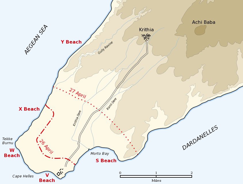
English: Map of the landing of the British 29th Division at Cape Helles on April 25, 1915 during the Battle of Gallipoli. The front line established by the night of April 26 is shown by the red dash-dot line. The front line reached by the night of April 27 is shown by the red dotted line. This became the "jumping off" line for the First Battle of Krithia. |
||
| Data | |||
| Font | Self created from map [1] in Hamilton, Ian (1920) Gallipoli Diary, Volume I, Category:New York: George H Doran Company | ||
| Autor | Gsl | ||
| Permís (Com reutilitzar aquest fitxer) |
|
||
| Altres versions |
|


![[1]](http://gutenberg.readingroo.ms/1/9/3/1/19317/19317-h/images/img-map.jpg)
Registre original de càrregues
La pàgina de descripció original era Helles landing map.jpg aquí. Els noms d'usuari a continuació es refereixen a en.wikipedia.
- 2004-05-16 06:37 Gsl 845×642× (64213 bytes)
Historial del fitxer
Cliqueu una data/hora per veure el fitxer tal com era aleshores.
| Data/hora | Miniatura | Dimensions | Usuari/a | Comentari | |
|---|---|---|---|---|---|
| actual | 20:20, 21 juny 2012 | | 845 × 642 (72 Ko) | Hohum | Sea to blue |
| 17:04, 6 maig 2005 |  | 845 × 642 (63 Ko) | Anathema | Map of the landing of the British 29th Division at Cape Helles, Gallipoli, on April 25, 1915. The front line established by the night of April 26 is shown by the red dash-dot line. The front line reached by the night of April 27 is shown by the red |
Ús del fitxer
La pàgina següent utilitza aquest fitxer:
Ús global del fitxer
Utilització d'aquest fitxer en altres wikis:
- Utilització a ar.wikipedia.org
- Utilització a ast.wikipedia.org
- Utilització a bg.wikipedia.org
- Utilització a cs.wikipedia.org
- Utilització a da.wikipedia.org
- Utilització a de.wikipedia.org
- Utilització a en.wikipedia.org
- Utilització a fr.wikipedia.org
- Utilització a fy.wikipedia.org
- Utilització a he.wikipedia.org
- Utilització a id.wikipedia.org
- Utilització a io.wikipedia.org
- Utilització a it.wikipedia.org
- Utilització a ko.wikipedia.org
- Utilització a no.wikipedia.org
- Utilització a pl.wikipedia.org
- Utilització a pt.wikipedia.org
- Utilització a ro.wikipedia.org
- Utilització a ru.wikipedia.org
- Utilització a sr.wikipedia.org
- Utilització a uk.wikipedia.org