
Fitxer:CongoCrisis Map.svg

Mida d'aquesta previsualització PNG del fitxer SVG: 593 × 600 píxels. Altres resolucions: 237 × 240 píxels | 475 × 480 píxels | 760 × 768 píxels | 1.013 × 1.024 píxels | 2.026 × 2.048 píxels | 637 × 644 píxels.
Fitxer original (fitxer SVG, nominalment 637 × 644 píxels, mida del fitxer: 168 Ko)
| Aquest fitxer i la informació mostrada a continuació provenen del dipòsit multimèdia lliure Wikimedia Commons. |
Resum
| Descripció |
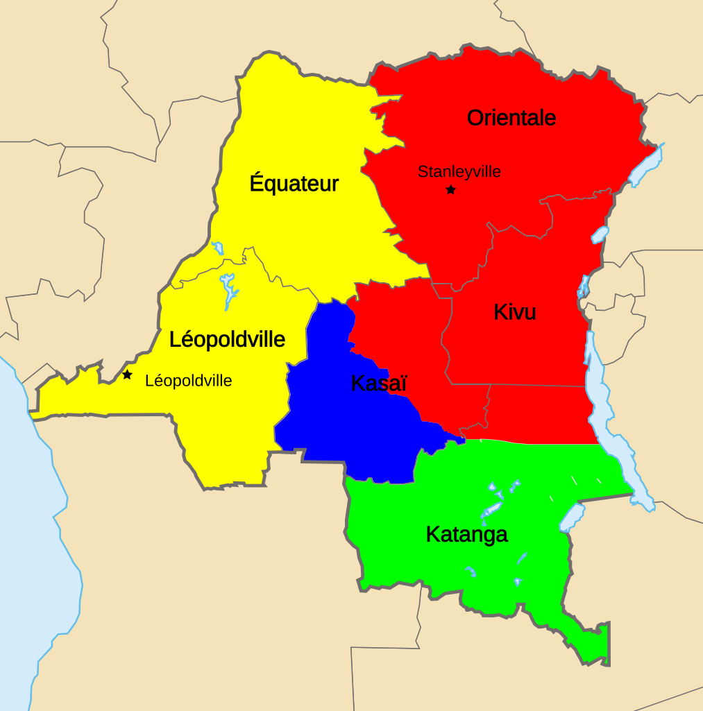
English (en): Map of Territorial Control during the Congo Crisis (1960-61).
National Government based in Léopoldville Rival National Government based in Stanleyville Katanga (Independent) Mining State of South Kasai (Autonomous)
Created with the GIMP; Made by User:Acntx == |
| Data | (UTC) |
| Font | |
| Autor |
|
| Això és una imatge retocada, cosa que vol dir que ha estat alterada digitalment de la seva versió original. Modificacions: {{{1}}}. L'original es pot veure a: Congo Kinshasa Template.svg:
|

|
Aquest fitxer SVG inclou text encapsulat que es pot traduir al vostre idioma utilitzant un editor que admeti SVG, un editor de text o l'eina de traducció de SVG. Per a més informació vegeu l'ajuda de traducció de fitxers SVG. |
Aquest fitxer està subjecte a la llicència de Creative Commons Reconeixement i Compartir Igual 3.0 No adaptada.
- Sou lliure de:
- compartir – copiar, distribuir i comunicar públicament l'obra
- adaptar – fer-ne obres derivades
- Amb les condicions següents:
- reconeixement – Heu de donar la informació adequada sobre l'autor, proporcionar un enllaç a la llicència i indicar si s'han realitzat canvis. Podeu fer-ho amb qualsevol mitjà raonable, però de cap manera no suggereixi que l'autor us dóna suport o aprova l'ús que en feu.
- compartir igual – Si modifiqueu, transformeu, o generareu amb el material, haureu de distribuir les vostres contribucions sota una llicència similar o una de compatible com l'original
Registre original de càrregues
This image is a derivative work of the following images:
- File:Congo_CrisisMap.png licensed with Cc-by-sa-3.0-migrated-with-disclaimers, GFDL-en
- 2010-08-10T13:57:01Z Beao 440x404 (11149 Bytes) Transparent.
- 2006-10-09T17:13:25Z Kelovy 440x404 (10193 Bytes) == Opis súboru == Map of Territorial Control during the Congo Crisis (1960-61). Color Key *'''Yellow''': National Government based in Léopoldville *'''Red''': Rival National Government based in Stanleyville *'''Green''':
- File:Congo_Kinshasa_Template.svg licensed with Cc-by-sa-2.5,2.0,1.0, Cc-by-sa-3.0-migrated, GFDL
- 2006-07-13T08:49:51Z Moyogo 640x647 (270716 Bytes) Lualaba province is Lualaba district + Kolwezi-city district
- 2006-05-28T19:43:22Z Moyogo 640x647 (268950 Bytes) split into layers, added provinces of 1960, 1966 and 1988.
- 2006-05-26T14:57:57Z Moyogo 640x647 (180669 Bytes) improvements to the template: added border of neighbouring countries, provinces' border are uniform, colours drawn from other maps on WP.
- 2005-09-30T10:36:59Z Moyogo 650x650 (117305 Bytes) Template for Province or District maps for the Congo Kinshasa. Each province has an ID in the form Province with the name, e.g. ProvinceKatanga The Provinces are only the outline stroke, no filling Each district has an ID i
Uploaded with derivativeFX
Historial del fitxer
Cliqueu una data/hora per veure el fitxer tal com era aleshores.
| Data/hora | Miniatura | Dimensions | Usuari/a | Comentari | |
|---|---|---|---|---|---|
| actual | 01:46, 7 març 2011 | | 637 × 644 (168 Ko) | Ras67 | cropped |
| 03:41, 6 des 2010 |  | 640 × 647 (219 Ko) | Themightyquill | removed equator line | |
| 03:23, 6 des 2010 |  | 640 × 647 (220 Ko) | Themightyquill | {{Information |Description=Map of Territorial Control during the Congo Crisis (1960-61). Color Key Yellow: National Government based in Léopoldville Red: Rival National Government based in Stanleyville Green: Katanga (Independent) Blue: Mining State o |
Ús del fitxer
La pàgina següent utilitza aquest fitxer:
Ús global del fitxer
Utilització d'aquest fitxer en altres wikis:
- Utilització a ja.wikipedia.org
- Utilització a www.wikidata.org