
Fitxer:De facto cantons of Rojava.png

Mida d'aquesta previsualització: 725 × 599 píxels. Altres resolucions: 290 × 240 píxels | 581 × 480 píxels | 929 × 768 píxels | 1.239 × 1.024 píxels | 2.000 × 1.653 píxels.
Fitxer original (2.000 × 1.653 píxels, mida del fitxer: 268 Ko, tipus MIME: image/png)
| Aquest fitxer i la informació mostrada a continuació provenen del dipòsit multimèdia lliure Wikimedia Commons. |

|
Aquesta imatge (de tipus mapa) s'hauria de tornar a crear utilitzant gràfics vectorials com ara un fitxer SVG. Això té diversos avantatges; en trobareu més informació a Commons:Media for cleanup. Si ja disposeu d'una versió d'aquesta imatge en format SVG, us preguem que la pengeu; després, reemplaceu aquesta plantilla amb la plantilla {{Vector version available|nom nou de la imatge.svg}} en aquesta imatge.
|
Resum
| Descripció |
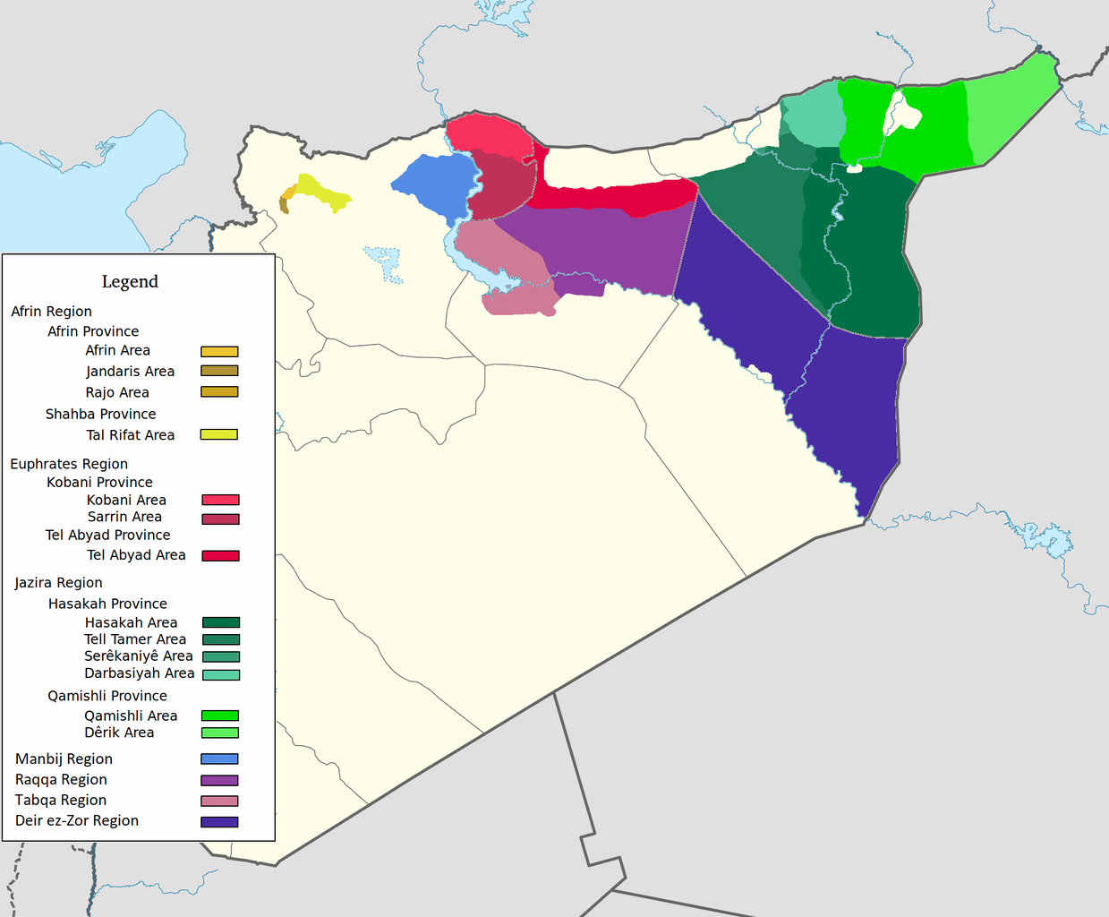
العربية: اقليم عفرين اقليم الفرات اقليم الجزيرة English: Afrin Region Euphrates Region Jazeera Region No region 한국어: 아프린 주 유프라테스 주 자제라 주 없음 |
| Data | |
| Font | Treball propi |
| Autor | Editor abcdef |
| Altres versions |
This image includes elements that have been taken or adapted from this file:  |
Llicència
Jo, el titular dels drets d'autor d'aquest treball, el public sota la següent llicència:
Aquest fitxer està subjecte a la llicència de Creative Commons Reconeixement i Compartir Igual 3.0 No adaptada.
- Sou lliure de:
- compartir – copiar, distribuir i comunicar públicament l'obra
- adaptar – fer-ne obres derivades
- Amb les condicions següents:
- reconeixement – Heu de donar la informació adequada sobre l'autor, proporcionar un enllaç a la llicència i indicar si s'han realitzat canvis. Podeu fer-ho amb qualsevol mitjà raonable, però de cap manera no suggereixi que l'autor us dóna suport o aprova l'ús que en feu.
- compartir igual – Si modifiqueu, transformeu, o generareu amb el material, haureu de distribuir les vostres contribucions sota una llicència similar o una de compatible com l'original
Historial del fitxer
Cliqueu una data/hora per veure el fitxer tal com era aleshores.
| Data/hora | Miniatura | Dimensions | Usuari/a | Comentari | |
|---|---|---|---|---|---|
| actual | 10:29, 27 maig 2020 | | 2.000 × 1.653 (268 Ko) | AntonSamuel | Reverted to version as of 09:02, 8 April 2020 (UTC) Restoring original map without stripes per COM:OW and discussion on the Rojava talk page on Wikipedia |
| 11:05, 8 abr 2020 |  | 2.000 × 1.653 (224 Ko) | Bill497 | Reverted to version as of 08:59, 8 April 2020 (UTC) Revert vandalism. | |
| 11:02, 8 abr 2020 |  | 2.000 × 1.653 (268 Ko) | AntonSamuel | Reverted to version as of 08:51, 8 April 2020 (UTC) Third, and last warning given on user talk page. | |
| 10:59, 8 abr 2020 |  | 2.000 × 1.653 (224 Ko) | Bill497 | Reverted to version as of 08:11, 8 April 2020 (UTC) Revert vandalism for a 3rd time. User is reverting a referenced map to an unreferenced version. | |
| 10:51, 8 abr 2020 |  | 2.000 × 1.653 (268 Ko) | AntonSamuel | Reverted to version as of 17:57, 7 April 2020 (UTC) Once again, use the Rojava talk page to discuss before making reverts and don't throw around unfounded vandalism claims. Second warning on talk page given. | |
| 10:11, 8 abr 2020 |  | 2.000 × 1.653 (224 Ko) | Bill497 | Reverted to version as of 11:10, 7 April 2020 (UTC) Revert vandalism. | |
| 19:57, 7 abr 2020 |  | 2.000 × 1.653 (268 Ko) | AntonSamuel | Reverted to version as of 00:50, 7 April 2020 (UTC) Restoring viewable version - Use Rojava talk page, warning left on user talk page | |
| 13:10, 7 abr 2020 |  | 2.000 × 1.653 (224 Ko) | Bill497 | Reverted to version as of 12:33, 2 April 2020 (UTC) Revert attempted vandalism into a factually incorrect version of the map. SDF has entirely no presence in some of the dashed zones. Due to fog of war these areas are all displaced as mixed with government control. Russia is the only reliable source displaying where the government is present. | |
| 02:50, 7 abr 2020 |  | 2.000 × 1.653 (268 Ko) | AntonSamuel | Continuation from below: ...manner. Further sources are needed apart from the Russian military maps - they cannot be considered to be neutral or factually accurate without additional verification. | |
| 02:46, 7 abr 2020 |  | 2.000 × 1.653 (218 Ko) | AntonSamuel | Clearing the 50/50 paint because of the visual difficulty and for deviation from the main purpose of this map - which is to display the various subregions of the civilian administration of the de facto autonomous region, not military control agreements such as SDF-SAA/Russia and SDF-US/US-led coalition which have no known civilian aspect as of date. Please discuss the issue first and foremost on the Rojava talk page if areas with an SAA/Russian or a US presence need to be highlighted in some... |
Ús del fitxer
Les 4 pàgines següents utilitzen aquest fitxer:
Ús global del fitxer
Utilització d'aquest fitxer en altres wikis:
- Utilització a ar.wikipedia.org
- Utilització a arz.wikipedia.org
- Utilització a azb.wikipedia.org
- Utilització a diq.wikipedia.org
- Utilització a fa.wikipedia.org
- Utilització a glk.wikipedia.org
- Utilització a id.wikipedia.org
- Utilització a ku.wikipedia.org
- Utilització a nl.wikipedia.org
- Utilització a ru.wikipedia.org
- Utilització a tr.wikipedia.org
- Utilització a vi.wikipedia.org
- Utilització a www.wikidata.org
- Utilització a zh.wikipedia.org