
Fitxer:EIA World Shale Gas Map-en.svg

Mida d'aquesta previsualització PNG del fitxer SVG: 636 × 318 píxels. Altres resolucions: 320 × 160 píxels | 640 × 320 píxels | 1.024 × 512 píxels | 1.280 × 640 píxels | 2.560 × 1.280 píxels.
Fitxer original (fitxer SVG, nominalment 636 × 318 píxels, mida del fitxer: 1,97 Mo)
| Aquest fitxer i la informació mostrada a continuació provenen del dipòsit multimèdia lliure Wikimedia Commons. |
Resum
| Descripció |
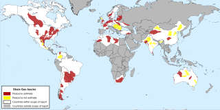
English: Map of major shale gas basins all over the world from the EIA report World Shale Gas Resources: An Initial Assessment of 14 Regions Outside the United States . |
| Data | |
| Font | http://www.eia.gov/analysis/studies/worldshalegas/ |
| Autor | Energy Information Administration |
| Altres versions |
|


Llicència
| This image is a work of a United States Department of Energy (or predecessor organization) employee, taken or made as part of that person's official duties. As a work of the U.S. federal government, the image is in the public domain.
Please note that national laboratories operate under varying licences and some are not free. Check the site policies of any national lab before crediting it with this tag.
|

|
Historial del fitxer
Cliqueu una data/hora per veure el fitxer tal com era aleshores.
| Data/hora | Miniatura | Dimensions | Usuari/a | Comentari | |
|---|---|---|---|---|---|
| actual | 18:11, 8 oct 2013 | | 636 × 318 (1,97 Mo) | Fulvio314 | {{Information |Description ={{en|1=Map of major shale gas basis all over the world from the EIA report ''World Shale Gas Resources: An Initial Assessment of 14 Regions Outside the United States ''.}} |Source =http://www.eia.gov/analysis/stud... |
Ús del fitxer
Les 2 pàgines següents utilitzen aquest fitxer:
Ús global del fitxer
Utilització d'aquest fitxer en altres wikis:
- Utilització a ar.wikipedia.org
- Utilització a be-tarask.wikipedia.org
- Utilització a bn.wikipedia.org
- Utilització a cs.wikipedia.org
- Utilització a cv.wikipedia.org
- Utilització a da.wikipedia.org
- Utilització a de.wikipedia.org
- Utilització a en.wikipedia.org
- Utilització a et.wikipedia.org
- Utilització a eu.wikipedia.org
- Utilització a fa.wikipedia.org
- Utilització a fr.wikipedia.org
- Utilització a hi.wikipedia.org
- Utilització a hu.wikipedia.org
- Utilització a id.wikipedia.org
- Utilització a it.wikipedia.org
- Utilització a ja.wikipedia.org
- Utilització a lt.wikipedia.org
- Utilització a ml.wikipedia.org
- Utilització a nl.wikipedia.org
- Utilització a no.wikipedia.org
- Utilització a pl.wikipedia.org
- Utilització a pt.wikipedia.org
- Utilització a ro.wikipedia.org
- Utilització a ru.wikipedia.org
- Utilització a ta.wikipedia.org
- Utilització a tr.wikipedia.org
- Utilització a uk.wikipedia.org
- Utilització a ur.wikipedia.org
- Utilització a zh-min-nan.wikipedia.org