
Fitxer:Ethiopia shaded relief map 1999, CIA.jpg

Mida d'aquesta previsualització: 498 × 599 píxels. Altres resolucions: 199 × 240 píxels | 399 × 480 píxels | 1.010 × 1.215 píxels.
Fitxer original (1.010 × 1.215 píxels, mida del fitxer: 222 Ko, tipus MIME: image/jpeg)
| Aquest fitxer i la informació mostrada a continuació provenen del dipòsit multimèdia lliure Wikimedia Commons. |
Resum
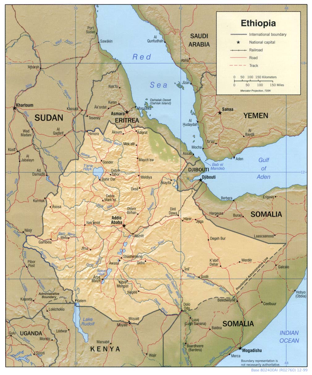
| Descripció | Shaded relief map of Ethiopia, 1999, produced by the U.S. Central Intelligence Agency. |
| Data | |
| Font |
University of Texas Libraries, Perry-Castañeda Library Map Collection: Ethiopia Maps |
| Autor | CIA |
| Altres versions |
Derivative works of this file: |
Llicència
| This image is a work of a Central Intelligence Agency employee, taken or made as part of that person's official duties. As a Work of the United States Government, this image or media is in the public domain in the United States.
|

|
Historial del fitxer
Cliqueu una data/hora per veure el fitxer tal com era aleshores.
| Data/hora | Miniatura | Dimensions | Usuari/a | Comentari | |
|---|---|---|---|---|---|
| actual | 13:23, 22 feb 2006 | | 1.010 × 1.215 (222 Ko) | Lupo | Shaded relief map of Ethiopia. Source: [http://www.lib.utexas.edu/maps/africa/ethiopia_rel99.jpg] from the [http://www.lib.utexas.edu/maps/ethiopia.html Perry-Castañeda Library Map Collection]. {{PD-USGov-CIA}} Category:Maps of Cameroon |
Ús del fitxer
La pàgina següent utilitza aquest fitxer:
Ús global del fitxer
Utilització d'aquest fitxer en altres wikis:
- Utilització a ar.wikipedia.org
- Utilització a ast.wikipedia.org
- Utilització a av.wikipedia.org
- Utilització a ba.wikipedia.org
- Utilització a bg.wikipedia.org
- Utilització a br.wikipedia.org
- Utilització a bs.wikipedia.org
- Utilització a ckb.wikipedia.org
- Utilització a cs.wikipedia.org
- Utilització a da.wikipedia.org
- Utilització a de.wikinews.org
- Utilització a el.wikipedia.org
- Utilització a en.wikipedia.org
- Utilització a fa.wikipedia.org
- Utilització a fr.wikipedia.org
- Utilització a gcr.wikipedia.org
- Utilització a he.wikipedia.org
- Utilització a he.wiktionary.org
- Utilització a hr.wiktionary.org
- Utilització a id.wikipedia.org
- Utilització a io.wikipedia.org
- Utilització a it.wikipedia.org
- Utilització a jv.wikipedia.org
- Utilització a ka.wikipedia.org
- Utilització a ku.wikipedia.org
- Utilització a la.wikipedia.org
- Utilització a ml.wikipedia.org
- Utilització a mzn.wikipedia.org
- Utilització a nl.wikipedia.org
- Utilització a no.wikipedia.org
- Utilització a os.wikipedia.org
- Utilització a pl.wikipedia.org
Vegeu més usos globals d'aquest fitxer.