
Fitxer:Europe 1740 en.png

Mida d'aquesta previsualització: 800 × 570 píxels. Altres resolucions: 320 × 228 píxels | 640 × 456 píxels | 1.024 × 730 píxels | 1.280 × 913 píxels | 2.560 × 1.825 píxels | 3.872 × 2.761 píxels.
Fitxer original (3.872 × 2.761 píxels, mida del fitxer: 1,25 Mo, tipus MIME: image/png)
| Aquest fitxer i la informació mostrada a continuació provenen del dipòsit multimèdia lliure Wikimedia Commons. |
_en.png)
.png)
.jpg)
Resum
| Descripció |
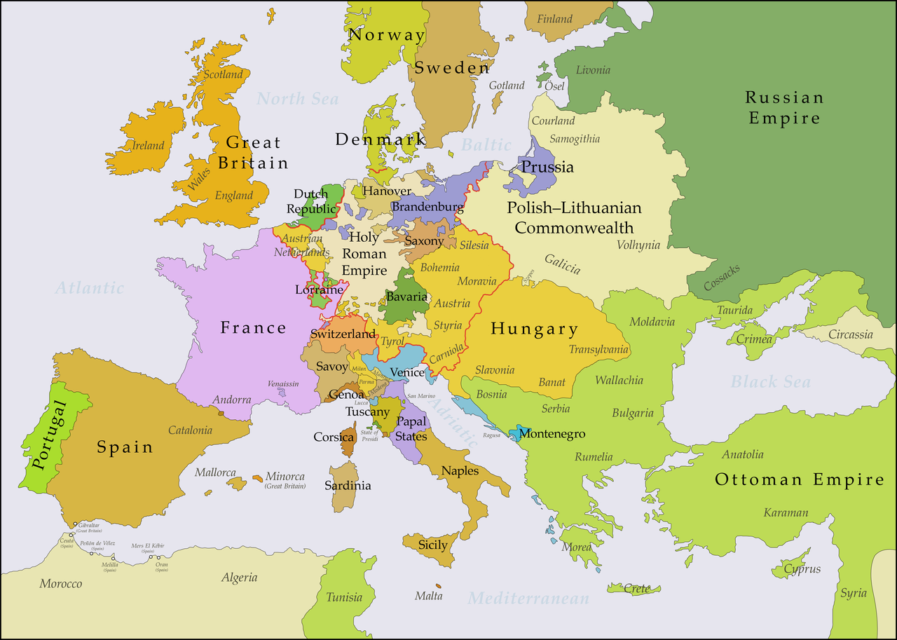
English: This map shows Europe in the years between the 1739 Treaty of Belgrade (the end of the Austro–Turkish War (1737–39)) and the beginning of the War of the Austrian Succession in 1740. The red line marks the borders of the Holy Roman Empire. The work was created with Inkscape and is mainly based on a map in: Putzger - Historischer Weltatlas, Berlin 1990, 78 pp. |
| Data | |
| Font | Treball propi, based on File:Europe 1748-1766 en.png |
| Autor | Bryan Rutherford |
Llicència
Jo, el titular dels drets d'autor d'aquest treball, el public sota la següent llicència:
This file is licensed under the Creative Commons Attribution-Share Alike 4.0 International license.
- Sou lliure de:
- compartir – copiar, distribuir i comunicar públicament l'obra
- adaptar – fer-ne obres derivades
- Amb les condicions següents:
- reconeixement – Heu de donar la informació adequada sobre l'autor, proporcionar un enllaç a la llicència i indicar si s'han realitzat canvis. Podeu fer-ho amb qualsevol mitjà raonable, però de cap manera no suggereixi que l'autor us dóna suport o aprova l'ús que en feu.
- compartir igual – Si modifiqueu, transformeu, o generareu amb el material, haureu de distribuir les vostres contribucions sota una llicència similar o una de compatible com l'original
Historial del fitxer
Cliqueu una data/hora per veure el fitxer tal com era aleshores.
| Data/hora | Miniatura | Dimensions | Usuari/a | Comentari | |
|---|---|---|---|---|---|
| actual | 23:49, 15 jul 2018 | | 3.872 × 2.761 (1,25 Mo) | Bryanrutherford0 | Added the Ionian Islands, made the Duchy of Milan a Habsburg possession |
| 04:28, 10 jul 2018 |  | 3.872 × 2.761 (1,25 Mo) | Bryanrutherford0 | Added Comtat Venaissin and redrew borders of Neuchâtel, Bishopric Basel, and Montbéliard | |
| 02:39, 3 oct 2017 |  | 3.872 × 2.761 (1,25 Mo) | Bryanrutherford0 | Transferred control of Saaremaa and Hiiumaa to Russia (1721 Treaty of Nystad) | |
| 14:50, 24 ago 2017 |  | 3.872 × 2.761 (1,25 Mo) | Bryanrutherford0 | Removed Prussian East Frisia (acquired 1744) | |
| 22:17, 23 ago 2017 |  | 3.872 × 2.761 (1,25 Mo) | Bryanrutherford0 | User created page with UploadWizard |
Ús del fitxer
Les 3 pàgines següents utilitzen aquest fitxer:
Ús global del fitxer
Utilització d'aquest fitxer en altres wikis:
- Utilització a azb.wikipedia.org
- Utilització a bg.wikipedia.org
- Utilització a cs.wikipedia.org
- Utilització a de.wikipedia.org
- Utilització a el.wikipedia.org
- Utilització a en.wikipedia.org
- Utilització a es.wikipedia.org
- Utilització a fa.wikipedia.org
- Utilització a fi.wikipedia.org
- Utilització a fr.wikipedia.org
- Utilització a gcr.wikipedia.org
- Utilització a he.wikipedia.org
- Utilització a id.wikipedia.org
- Utilització a it.wikipedia.org
- Utilització a ja.wikipedia.org
- Utilització a lv.wikipedia.org
- Utilització a pt.wikipedia.org
- Utilització a ru.wikipedia.org
- Utilització a sr.wikipedia.org
- Utilització a zh.wikipedia.org