
Fitxer:Europe topography map en.png

Mida d'aquesta previsualització: 737 × 599 píxels. Altres resolucions: 295 × 240 píxels | 590 × 480 píxels | 944 × 768 píxels | 1.259 × 1.024 píxels | 1.473 × 1.198 píxels.
Fitxer original (1.473 × 1.198 píxels, mida del fitxer: 728 Ko, tipus MIME: image/png)
| Aquest fitxer i la informació mostrada a continuació provenen del dipòsit multimèdia lliure Wikimedia Commons. |
Resum
| Descripció |
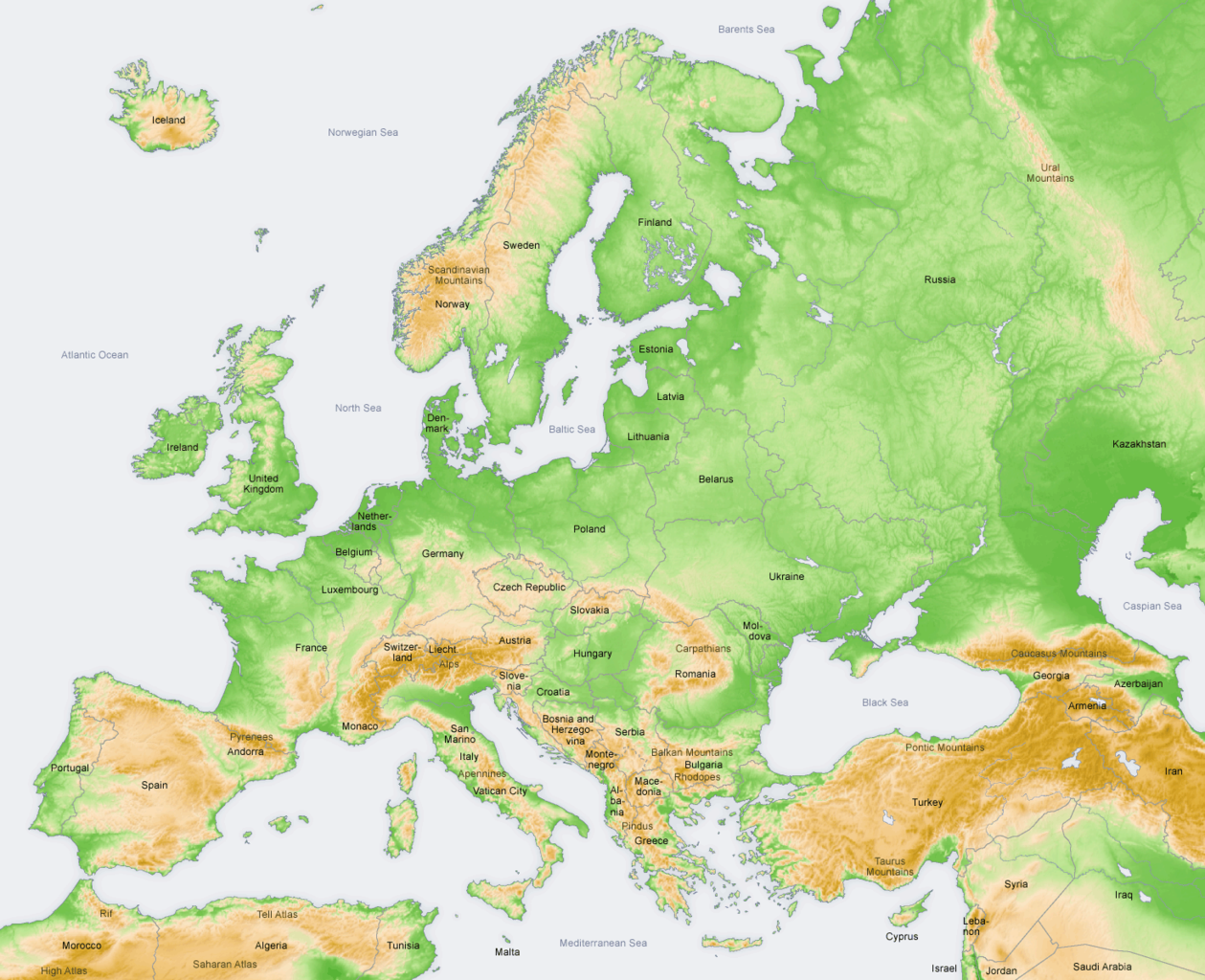
English: Topography in Europe, map in English. |
| Data | |
| Font | own map, based on the Generic Mapping Tools and ETOPO2 |
| Autor | San Jose |
| Altres versions |
[]
|


Llicència
The map has been created with the Generic Mapping Tools: https://www.generic-mapping-tools.org/ using one or more of these public-domain datasets for the relief:
|

|
S'autoritza la còpia, la distribució i la modificació d'aquest document sota els termes de la llicència de documentació lliure GNU versió 1.2 o qualsevol altra versió posterior que publiqui la Free Software Foundation; sense seccions invariants, ni textos de portada, ni textos de contraportada. S'inclou una còpia d'aquesta llicència en la secció titulada GNU Free Documentation License. |
| Aquest fitxer està subjecte a la llicència de Creative Commons Reconeixement i Compartir Igual 3.0 No adaptada. | ||
| ||
| Aquest avís de llicència s'ha afegit a aquest fitxer d'acord amb l'actualització de la llicència GFDL. |
Historial del fitxer
Cliqueu una data/hora per veure el fitxer tal com era aleshores.
| Data/hora | Miniatura | Dimensions | Usuari/a | Comentari | |
|---|---|---|---|---|---|
| actual | 12:40, 3 jul 2010 | | 1.473 × 1.198 (728 Ko) | Ras67 | cropped |
| 10:45, 12 juny 2008 |  | 1.475 × 1.200 (729 Ko) | San Jose | update | |
| 15:27, 5 juny 2006 |  | 1.475 × 1.200 (782 Ko) | San Jose | updated and corrected | |
| 14:41, 2 abr 2006 |  | 1.475 × 1.200 (781 Ko) | San Jose | Upload |
Ús del fitxer
Les 2 pàgines següents utilitzen aquest fitxer:
Ús global del fitxer
Utilització d'aquest fitxer en altres wikis:
- Utilització a ar.wikipedia.org
- Utilització a ast.wikipedia.org
- Utilització a bg.wikipedia.org
- Utilització a bn.wikipedia.org
- Utilització a bs.wikipedia.org
- Utilització a cs.wikipedia.org
- Utilització a da.wikipedia.org
- Utilització a de.wikipedia.org
- Utilització a el.wikipedia.org
- Utilització a en.wikipedia.org
- Utilització a eo.wikipedia.org
- Utilització a es.wikipedia.org
- Utilització a eu.wikipedia.org
- Utilització a fa.wikipedia.org
- Utilització a fi.wikipedia.org
- Utilització a fi.wikivoyage.org
- Utilització a hi.wikipedia.org
- Utilització a id.wikipedia.org
- Utilització a incubator.wikimedia.org
- Utilització a io.wikipedia.org
- Utilització a it.wikipedia.org
- Utilització a ja.wikipedia.org
- Utilització a ka.wikipedia.org
- Utilització a ko.wikipedia.org
- Utilització a lez.wikipedia.org
- Utilització a li.wikibooks.org
- Utilització a lv.wikipedia.org
Vegeu més usos globals d'aquest fitxer.