
Fitxer:Expulsion map of the Circassians in 19th century.PNG
No hi ha cap versió amb una resolució més gran.
Expulsion_map_of_the_Circassians_in_19th_century.PNG (491 × 445 píxels, mida del fitxer: 15 Ko, tipus MIME: image/png)
| Aquest fitxer i la informació mostrada a continuació provenen del dipòsit multimèdia lliure Wikimedia Commons. |
Resum
| Descripció |
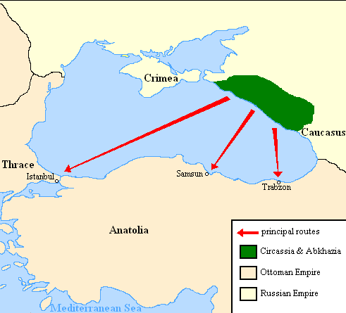
English: Map showing the location of Circassia and the expulsion routes (1859-1864) of the Circassians and other Caucasian peoples to the Ottoman Empire, after the Russian annexation of the North-Caucasus following the Crimean War of 1853-1856.
I used the information of the following two maps: http://www.circassianworld.com/CIRCASSIA1840.jpg And the books: The Northwest Caucasus: past, present, future, Walter Richmond The forgotten minorities of Eastern Europe, Arno TannerРусский: Карта с указанием местонахождения Черкесии и высылки маршрутов (1859-1864) от черкесов и других кавказских народов в состав Османской империи, после русской аннексии Северо-Кавказского следующие Крымской войны 1853-1856 гг. |
| Data | |
| Font | Treball propi |
| Autor | DragonTiger23 |
Llicència
| Jo, el titular del copyright d'aquesta obra, l'allibero al domini públic. Això s'aplica a tot el món. En alguns països això pot no ser legalment possible, en tal cas: Jo faig concessió a tothom del dret d'usar aquesta obra per a qualsevol propòsit, sense cap condició llevat d'aquelles requerides per la llei. |
Historial del fitxer
Cliqueu una data/hora per veure el fitxer tal com era aleshores.
| Data/hora | Miniatura | Dimensions | Usuari/a | Comentari | |
|---|---|---|---|---|---|
| actual | 22:06, 5 jul 2013 | | 491 × 445 (15 Ko) | Irānshahr | |
| 04:01, 4 jul 2013 |  | 491 × 445 (15 Ko) | Irānshahr | Olahus is correct. | |
| 11:23, 3 jul 2013 |  | 491 × 445 (15 Ko) | DragonTiger23 | Reverted to version as of 18:05, 11 February 2011 | |
| 15:23, 9 des 2011 |  | 491 × 445 (15 Ko) | Olahus | The Circassian inhabited region was actually much bigger. | |
| 20:05, 11 feb 2011 |  | 491 × 445 (15 Ko) | DragonTiger23 | {{Information |Description ={{en|1=Map showing the location of Circassia and the expulsion routes (1859-1864) of the Circassians and other Caucasian peoples to the Ottoman Empire, after the Russian annexation of the North-Caucasus following the Crimean |
Ús del fitxer
La pàgina següent utilitza aquest fitxer:
Ús global del fitxer
Utilització d'aquest fitxer en altres wikis:
- Utilització a bg.wikipedia.org
- Utilització a de.wikipedia.org
- Utilització a it.wikipedia.org
- Utilització a ja.wikipedia.org
- Utilització a lmo.wikipedia.org
- Utilització a nl.wikipedia.org
- Utilització a pl.wikipedia.org
- Utilització a ru.wikipedia.org
- Utilització a ru.wikinews.org
- Utilització a sh.wikipedia.org
- Utilització a tr.wikipedia.org