
Fitxer:Great-neck-ny-map.gif
No hi ha cap versió amb una resolució més gran.
Great-neck-ny-map.gif (575 × 425 píxels, mida del fitxer: 57 Ko, tipus MIME: image/gif)
| Aquest fitxer i la informació mostrada a continuació provenen del dipòsit multimèdia lliure Wikimedia Commons. |
Resum
| Descripció |
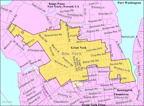
English: U.S. Census 2000 reference map for Great Neck, New York. The amber and light cross-hatched areas bordered in magenta indicate the census tracts included in the census-designated place. The amber-colored areas bordered in black indicate the extent of the incorporated Village of Great Neck. The extent of "Great Neck, New York" as the term is used by the United States Postal Service, local government and local residents includes all the incorporated and unincorporated areas of the entire Great Neck peninsula, as well as an area south of the peninsula extending to the border with Queens (New York City). |
| Data | |
| Font |
|
| Autor | United States Census Bureau |
Llicència
This image or file is a work of a United States Census Bureau employee, taken or made as part of that person's official duties. As a work of the U.S. federal government, the image is in the public domain.
|
 |
Registre original de càrregues
La pàgina de descripció original era aquí. Els noms d'usuari a continuació es refereixen a en.wikipedia.
Upload date | User | Bytes | Dimensions | Comment
- 2007-11-28 00:59 (UTC) | Americasroof | 58710 (bytes) | 575×425 | [[Great Neck, New York]] map from U.S. Census
Historial del fitxer
Cliqueu una data/hora per veure el fitxer tal com era aleshores.
| Data/hora | Miniatura | Dimensions | Usuari/a | Comentari | |
|---|---|---|---|---|---|
| actual | 15:33, 10 gen 2012 | | 575 × 425 (57 Ko) | SreeBot | (Original text) : Great Neck, New York map from U.S. Census |
Ús del fitxer
La pàgina següent utilitza aquest fitxer:
Ús global del fitxer
Utilització d'aquest fitxer en altres wikis:
- Utilització a cy.wikipedia.org
- Utilització a en.wikipedia.org
- Utilització a eu.wikipedia.org
- Utilització a fa.wikipedia.org
- Utilització a fr.wikipedia.org
- Utilització a ht.wikipedia.org
- Utilització a sh.wikipedia.org
- Utilització a sr.wikipedia.org
- Utilització a www.wikidata.org