
Fitxer:Hatay (tr).svg

Mida d'aquesta previsualització PNG del fitxer SVG: 370 × 600 píxels. Altres resolucions: 148 × 240 píxels | 296 × 480 píxels | 474 × 768 píxels | 632 × 1.024 píxels | 1.264 × 2.048 píxels | 511 × 828 píxels.
Fitxer original (fitxer SVG, nominalment 511 × 828 píxels, mida del fitxer: 36 Ko)
| Aquest fitxer i la informació mostrada a continuació provenen del dipòsit multimèdia lliure Wikimedia Commons. |
.svg?uselang=ca)
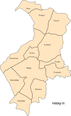
Hatay ilçe haritası / map of province Hatay with subdivisions
| S'ha alliberat aquesta obra al domini públic pel seu autor katpatuka. Això s'aplica a tot el món. En alguns països això pot no ser legalment possible, en tal cas: |
Historial del fitxer
Cliqueu una data/hora per veure el fitxer tal com era aleshores.
| Data/hora | Miniatura | Dimensions | Usuari/a | Comentari | |
|---|---|---|---|---|---|
| actual | 22:15, 14 nov 2006 | | 511 × 828 (36 Ko) | Katpatuka | Hatay ilçe haritası / map of province Hatay with subdivisions {{PD-user|katpatuka}} Category:SVG maps of Turkey |
Ús del fitxer
La pàgina següent utilitza aquest fitxer:
Ús global del fitxer
Utilització d'aquest fitxer en altres wikis:
- Utilització a ar.wikipedia.org
- Utilització a ast.wikipedia.org
- Utilització a az.wikipedia.org
- Utilització a ce.wikipedia.org
- Utilització a cs.wikipedia.org
- Utilització a cy.wikipedia.org
- Utilització a diq.wikipedia.org
- Utilització a eo.wikipedia.org
- Utilització a eu.wikipedia.org
- Utilització a fi.wikipedia.org
- Utilització a he.wikipedia.org
- Utilització a hy.wikipedia.org
- Utilització a ku.wikipedia.org
- Utilització a mzn.wikipedia.org
- Utilització a no.wikipedia.org
- Utilització a pl.wikipedia.org
- Utilització a ro.wikipedia.org
- Utilització a ru.wikipedia.org
- Utilització a sr.wikipedia.org
- Utilització a tg.wikipedia.org
- Utilització a tr.wikiquote.org
- Utilització a uk.wikipedia.org
- Utilització a www.wikidata.org
.svg)