
Fitxer:IndigoBuntingRangeMapCropped.png
No hi ha cap versió amb una resolució més gran.
IndigoBuntingRangeMapCropped.png (360 × 330 píxels, mida del fitxer: 6 Ko, tipus MIME: image/png)
| Aquest fitxer i la informació mostrada a continuació provenen del dipòsit multimèdia lliure Wikimedia Commons. |
Resum
| Descripció |
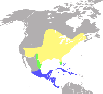
English: Range map of the Indigo Bunting, Passerina cyanea, based on the map at Nature Serve.org [1] and the map in A Field Guide to the Birds East of the Rockies by Roger Tory Peterson. Cropped version.
Yellow indicates summer range, green indicates migratory range, blue indicates winter range |
| Data | |
| Font | Treball propi |
| Autor | Hey jude, don't let me down |
Llicència
| Jo, el titular del copyright d'aquesta obra, l'allibero al domini públic. Això s'aplica a tot el món. En alguns països això pot no ser legalment possible, en tal cas: Jo faig concessió a tothom del dret d'usar aquesta obra per a qualsevol propòsit, sense cap condició llevat d'aquelles requerides per la llei. |
Historial del fitxer
Cliqueu una data/hora per veure el fitxer tal com era aleshores.
| Data/hora | Miniatura | Dimensions | Usuari/a | Comentari | |
|---|---|---|---|---|---|
| actual | 14:47, 15 jul 2008 | | 360 × 330 (6 Ko) | Hey jude, don't let me down | {{Information |Description={{en|1=Range map of the Indigo Bunting, ''Passerina cyanea'', based on the map at Nature Serve.org [http://www.natureserve.org/infonatura/servlet/InfoNatura?searchName=Passerina+cyanea#rangemap] and the map in ''A Field Guide to |
Ús del fitxer
La pàgina següent utilitza aquest fitxer:
Ús global del fitxer
Utilització d'aquest fitxer en altres wikis:
- Utilització a ast.wikipedia.org
- Utilització a bg.wikipedia.org
- Utilització a ceb.wikipedia.org
- Utilització a cs.wikipedia.org
- Utilització a cy.wikipedia.org
- Utilització a de.wikipedia.org
- Utilització a en.wikipedia.org
- Utilització a es.wikipedia.org
- Utilització a eu.wikipedia.org
- Utilització a fa.wikipedia.org
- Utilització a fr.wikipedia.org
- Utilització a hu.wikipedia.org
- Utilització a nl.wikipedia.org
- Utilització a nv.wikipedia.org
- Utilització a pl.wikipedia.org
- Utilització a ro.wikipedia.org
- Utilització a ru.wikipedia.org
- Utilització a species.wikimedia.org
- Utilització a sv.wikipedia.org
- Utilització a uk.wikipedia.org
- Utilització a vi.wikipedia.org
- Utilització a www.wikidata.org
- Utilització a zh.wikipedia.org