
Fitxer:Juba map.jpg
No hi ha cap versió amb una resolució més gran.
Juba_map.jpg (519 × 533 píxels, mida del fitxer: 67 Ko, tipus MIME: image/jpeg)
| Aquest fitxer i la informació mostrada a continuació provenen del dipòsit multimèdia lliure Wikimedia Commons. |
| Descripció |
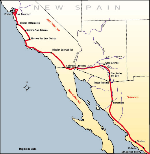
English: Map of the route, Juan Bautista de Anza travelled in 1775-76 from Mexico to todays San Francisco, where he founded the Presidio of San Francisco. Español: Mapa de la ruta que Juan Bautista de Anza recorrió en 1775-76 desde México hasta la actual San Francisco, donde fundó el Presidio de San Francisco. |
|||
| Font | http://www.nps.gov/juba | |||
| Autor | ||||
| Permís (Com reutilitzar aquest fitxer) |
|
Historial del fitxer
Cliqueu una data/hora per veure el fitxer tal com era aleshores.
| Data/hora | Miniatura | Dimensions | Usuari/a | Comentari | |
|---|---|---|---|---|---|
| actual | 22:53, 10 jul 2006 | | 519 × 533 (67 Ko) | H-stt | {{Information |Description= Map of the route, Juan Bautista de Anza travelled in 1775-76 from Baja California to todays San Francisco, where he founded the Presidio of San Francisco |Source= http://www.nps.gov/juba |Date= |Author= |Permission= {{PD-USGov |
Ús del fitxer
La pàgina següent utilitza aquest fitxer:
Ús global del fitxer
Utilització d'aquest fitxer en altres wikis:
- Utilització a bg.wikipedia.org
- Utilització a en.wikipedia.org
- Utilització a es.wikipedia.org
- Utilització a hy.wikipedia.org
- Utilització a ja.wikipedia.org