
Fitxer:Kashmir Region (2020 skirmish locations).jpg
Mida d'aquesta previsualització: 604 × 599 píxels. Altres resolucions: 242 × 240 píxels | 484 × 480 píxels | 774 × 768 píxels | 1.033 × 1.024 píxels | 1.579 × 1.566 píxels.
Fitxer original (1.579 × 1.566 píxels, mida del fitxer: 1,27 Mo, tipus MIME: image/jpeg)
| Aquest fitxer i la informació mostrada a continuació provenen del dipòsit multimèdia lliure Wikimedia Commons. |
.jpg?uselang=ca)
Resum
| Descripció |
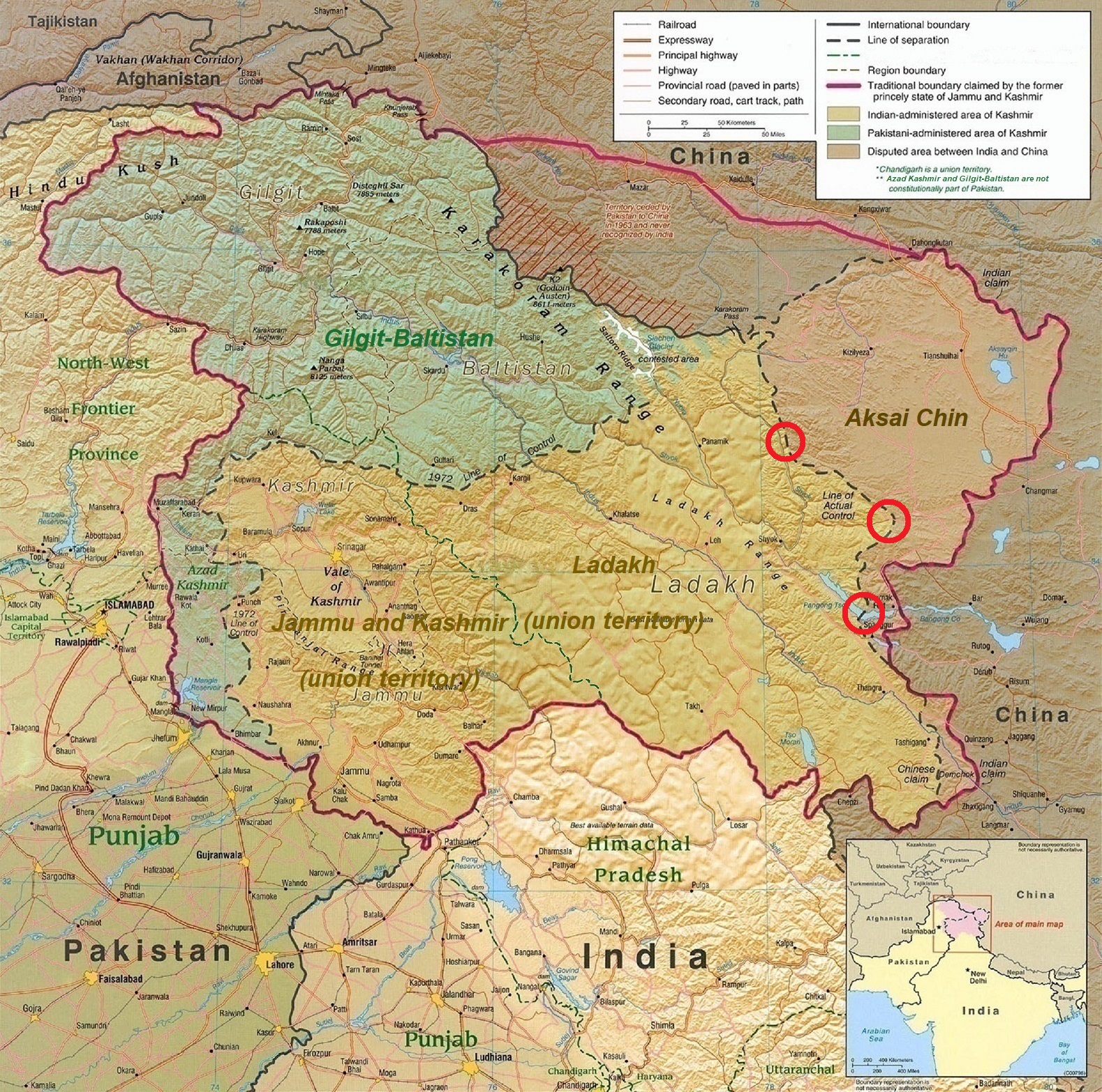
English: A map of the disputed Kashmir region created by the United States CIA in 2004 and hosted by the University of Texas at Austin Perry-Castañeda Library Map Collection; altered to show new jurisdictions by Fowler&fowler in November 2019; altered by to show 2020 skirmish locations by MarkH21 in June 2020. The red circles mark the rough locations of the conflicts at the the Galwan Valley (top), Hot Springs, Chang Chenmo Valley checkpoint (middle), and Pangong Tso (near the bottom). |
| Data | |
| Font | Map of Kashmir region created by the US Central Intelligence Agency, 2004 |
| Autor | United States Central Intelligence Agency |
| Altres versions |
  |
Llicència
Aquesta obra és en el domini públic als Estats Units perquè és una obra del govern federal dels Estats Units sota els termes del Títol 17, Capítol 1, Secció 105 del Codi dels EUA. Vegeu drets d'autor.
Nota: Això només s'aplica a obres del Govern Federal i no a les dels estats individuals ni cap altra subdivisió administrativa. Aquesta plantilla tampoc no s'aplica a dissenys de segells de correus publicats pel Servei Postal dels Estats Units des de 1978 (vegeu 206.02(b) of Compendium II: Copyright Office Practices).
|
 | |
| Aquest fitxer està identificat com a lliure de restriccions conegudes sota la llei de drets d'autor, inclosos els drets veïns. | ||
| Anotacions | Aquesta imatge té anotacions: Vegeu-les a Commons |
.jpg)
Historial del fitxer
Cliqueu una data/hora per veure el fitxer tal com era aleshores.
| Data/hora | Miniatura | Dimensions | Usuari/a | Comentari | |
|---|---|---|---|---|---|
| actual | 20:45, 24 juny 2020 | | 1.579 × 1.566 (1,27 Mo) | MarkH21 | Removed the Daulat Beg Oldi circle as not being an actual location of conflict; added the Hot Springs, Chang Chenmo Valley circle as an actual location of conflict. |
| 04:01, 24 juny 2020 |  | 1.579 × 1.566 (1,27 Mo) | MarkH21 | Uploaded a work by United States Central Intelligence Agency, MarkH21 from [https://legacy.lib.utexas.edu/maps/middle_east_and_asia/kashmir_region_2004.jpg Map of Kashmir region] created by the US Central Intelligence Agency, 2004; altered by MarkH21 with UploadWizard |
Ús del fitxer
La pàgina següent utilitza aquest fitxer:
Ús global del fitxer
Utilització d'aquest fitxer en altres wikis:
- Utilització a af.wikipedia.org
- Utilització a en.wikipedia.org
- Utilització a es.wikipedia.org
- Utilització a fa.wikipedia.org
- Utilització a fr.wikipedia.org
- Utilització a he.wikipedia.org
- Utilització a ja.wikipedia.org
- Utilització a ka.wikipedia.org
- Utilització a ml.wikipedia.org
- Utilització a ne.wikipedia.org
- Utilització a pnb.wikipedia.org
- Utilització a pt.wikipedia.org
- Utilització a ru.wikipedia.org
- Utilització a simple.wikipedia.org
- Utilització a so.wikipedia.org
- Utilització a ta.wikipedia.org
- Utilització a te.wikipedia.org
- Utilització a th.wikipedia.org
- Utilització a tr.wikipedia.org
- Utilització a uk.wikipedia.org
- Utilització a ur.wikipedia.org
- Utilització a vi.wikipedia.org
- Utilització a www.wikidata.org
- Utilització a zh.wikipedia.org
.jpg)