
Fitxer:Khuriya muriya 76.jpg

No hi ha cap versió amb una resolució més gran.
Khuriya_muriya_76.jpg (436 × 360 píxels, mida del fitxer: 31 Ko, tipus MIME: image/jpeg)
| Aquest fitxer i la informació mostrada a continuació provenen del dipòsit multimèdia lliure Wikimedia Commons. |
Resum
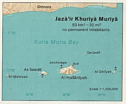
| Descripció |
Deutsch: Karte der Kuria-Muria-Inseln (Oman) im Indischen Ozean
English: Map of Khuriya Muriya Islands (Oman) in the Indian Ocean |
| Data | |
| Font | http://www.lib.utexas.edu/maps/islands_oceans_poles/jaza'ir_khuriya_muriya.jpg |
| Autor | Taken from Perry-Castañeda Library (PCL), originally from CIA Indian Ocean Atlas |
Llicència
| This image is a work of a Central Intelligence Agency employee, taken or made as part of that person's official duties. As a Work of the United States Government, this image or media is in the public domain in the United States.
|

|
Historial del fitxer
Cliqueu una data/hora per veure el fitxer tal com era aleshores.
| Data/hora | Miniatura | Dimensions | Usuari/a | Comentari | |
|---|---|---|---|---|---|
| actual | 13:50, 10 jul 2007 | | 436 × 360 (31 Ko) | Telim tor | == Information == {{Information |Description= {{de|Karte der Kuria-Muria-Inseln (Oman) im Indischen Ozean}} {{en|Map of Khuriya Muriya Islands (Oman) in the Indian Ocean}} |Source=http://www.lib.utexas.edu/maps/islands_oceans_poles/jaza'ir_khuriya_muriya. |
Ús del fitxer
La pàgina següent utilitza aquest fitxer:
Ús global del fitxer
Utilització d'aquest fitxer en altres wikis:
- Utilització a ar.wikipedia.org
- Utilització a az.wikipedia.org
- Utilització a be.wikipedia.org
- Utilització a ceb.wikipedia.org
- Utilització a cs.wikipedia.org
- Utilització a de.wikipedia.org
- Utilització a en.wikipedia.org
- Utilització a eo.wikipedia.org
- Utilització a es.wikipedia.org
- Utilització a fa.wikipedia.org
- Utilització a fi.wikipedia.org
- Utilització a fr.wikipedia.org
- Utilització a it.wikipedia.org
- Utilització a ja.wikipedia.org
- Utilització a lt.wikipedia.org
- Utilització a nl.wikipedia.org
- Utilització a nn.wikipedia.org
- Utilització a no.wikipedia.org
- Utilització a pl.wikipedia.org
- Utilització a pt.wikipedia.org
- Utilització a ru.wikipedia.org
- Utilització a sr.wikipedia.org
- Utilització a sv.wikipedia.org
- Utilització a uk.wikipedia.org
- Utilització a www.wikidata.org
- Utilització a zh.wikipedia.org