
Fitxer:Livingston-Island-Map-2010.jpg

Mida d'aquesta previsualització: 800 × 555 píxels. Altres resolucions: 320 × 222 píxels | 640 × 444 píxels | 1.024 × 710 píxels | 1.280 × 888 píxels | 2.560 × 1.776 píxels | 5.027 × 3.487 píxels.
Fitxer original (5.027 × 3.487 píxels, mida del fitxer: 7,07 Mo, tipus MIME: image/jpeg)
| Aquest fitxer i la informació mostrada a continuació provenen del dipòsit multimèdia lliure Wikimedia Commons. |
Resum
| Descripció |
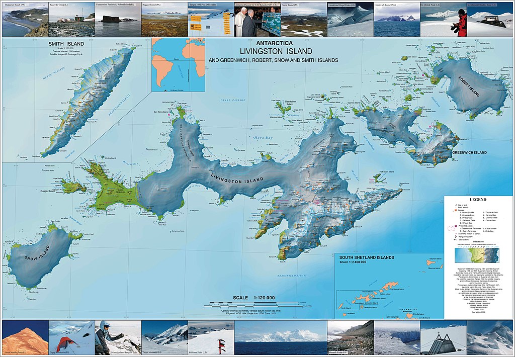
English: L.L. Ivanov. Antarctica: Livingston Island and Greenwich, Robert, Snow and Smith Islands. Scale 1:120000 topographic map. Troyan: Manfred Wörner Foundation, 2010. ISBN 978-954-92032-9-5 (First edition 2009. ISBN 978-954-92032-6-4) |
| Data | |
| Font | Treball propi |
| Autor | Apcbg |
| Permís (Com reutilitzar aquest fitxer) |
Llicència
Jo, el titular dels drets d'autor d'aquest treball, el public sota la següent llicència:
This file is licensed under the Creative Commons Attribution-Share Alike 4.0 International license.
- Sou lliure de:
- compartir – copiar, distribuir i comunicar públicament l'obra
- adaptar – fer-ne obres derivades
- Amb les condicions següents:
- reconeixement – Heu de donar la informació adequada sobre l'autor, proporcionar un enllaç a la llicència i indicar si s'han realitzat canvis. Podeu fer-ho amb qualsevol mitjà raonable, però de cap manera no suggereixi que l'autor us dóna suport o aprova l'ús que en feu.
- compartir igual – Si modifiqueu, transformeu, o generareu amb el material, haureu de distribuir les vostres contribucions sota una llicència similar o una de compatible com l'original
Published by the Manfred Wörner Foundation, and hereby released by the Foundation’s President and CEO Apcbg (Lyubomir Ivanov) for publication under the Creative Commons Attribution ShareAlike 4.0 license.
Historial del fitxer
Cliqueu una data/hora per veure el fitxer tal com era aleshores.
| Data/hora | Miniatura | Dimensions | Usuari/a | Comentari | |
|---|---|---|---|---|---|
| actual | 06:46, 29 juny 2015 | | 5.027 × 3.487 (7,07 Mo) | Apcbg | {{Information |Description ={{en|1= L.L. Ivanov. Antarctica: Livingston Island and Greenwich, Robert, Snow and Smith Islands. Scale 1:120000 topographic map. Troyan: Manfred Wörner Foundation, 2010. ISBN 978-954-92032-9-5 (First edition 2009. ISBN... |
Ús del fitxer
La pàgina següent utilitza aquest fitxer:
Ús global del fitxer
Utilització d'aquest fitxer en altres wikis:
- Utilització a af.wikipedia.org
- Utilització a ar.wikipedia.org
- Utilització a ast.wikipedia.org
- Utilització a az.wikipedia.org
- Cənubi Şetland adaları
- Mikalvi buxtası
- Kruni buxtası
- Zahari burnu
- Neqra burnu
- Edvards burnu
- Robert burnu
- Tsepina buxtası
- Somovit burnu
- Batuliya burnu
- Sadala burnu
- Kitçen burnu
- Smirnenski burnu
- Qarinya buxtası
- Qrinviç adası
- Misnomer burnu
- Debelyanov burnu
- Hammer burnu
- Nevestino buxtası
- Katarina burnu
- Kozloduy buxtası
- Perelik burnu
- Vrabça buxtası
- Yundola buxtası
- Lavrenov burnu
- Uqarçi burnu
- Hidra buxtası
- Zornitsa buxtası
- Skesa burnu
- Rove burnu
- Nedelya burnu
- Bilyar burnu
- Sparadok burnu
- Livinqston adası
- Lakatnik burnu
- Lista burnu
- Amadok burnu
- Kokalyane burnu
- Uqain burnu
- İrnik burnu
- Mezdra burnu
- Byevoter burnu
- Esteverena burnu
- Monroye burnu
- Barutin buxtası
- Vokil burnu
- İvaylo buxtası
Vegeu més usos globals d'aquest fitxer.