
Fitxer:Location map Rockall.jpg

Mida d'aquesta previsualització: 709 × 600 píxels. Altres resolucions: 284 × 240 píxels | 567 × 480 píxels | 908 × 768 píxels | 1.210 × 1.024 píxels | 1.300 × 1.100 píxels.
Fitxer original (1.300 × 1.100 píxels, mida del fitxer: 857 Ko, tipus MIME: image/jpeg)
| Aquest fitxer i la informació mostrada a continuació provenen del dipòsit multimèdia lliure Wikimedia Commons. |
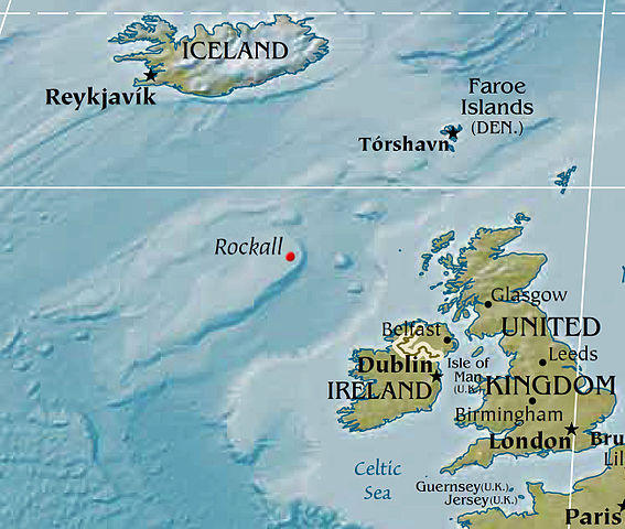
Map displaying the location of Rockall, based on a PD CIA world map. Political designations removed by Bjarki.
This image is in the public domain because it contains materials that originally came from the United States Central Intelligence Agency's World Factbook.
|
 |
Historial del fitxer
Cliqueu una data/hora per veure el fitxer tal com era aleshores.
| Data/hora | Miniatura | Dimensions | Usuari/a | Comentari | |
|---|---|---|---|---|---|
| actual | 04:02, 8 feb 2016 | | 1.300 × 1.100 (857 Ko) | Nagualdesign | Removed political designation ("UK"), since the area is disputed. |
| 07:32, 28 des 2015 |  | 1.300 × 1.100 (855 Ko) | Nagualdesign | Updated (better resolution) using CIA map. | |
| 15:34, 23 abr 2005 |  | 615 × 520 (119 Ko) | Bjarki S | Map displaying the location of Rockall, based on a PD CIA world map. Political designations removed by Bjarki. {{PD-USGov-CIA-WF}} |
Ús del fitxer
No hi ha pàgines que utilitzin aquest fitxer.
Ús global del fitxer
Utilització d'aquest fitxer en altres wikis:
- Utilització a br.wikipedia.org
- Utilització a cs.wikipedia.org
- Utilització a de.wikipedia.org
- Utilització a en.wikipedia.org
- Utilització a eu.wikipedia.org
- Utilització a fy.wikipedia.org
- Utilització a id.wikipedia.org
- Utilització a is.wikipedia.org
- Utilització a ko.wikipedia.org
- Utilització a nl.wikipedia.org
- Utilització a nn.wikipedia.org
- Utilització a pnb.wikipedia.org
- Utilització a sr.wikipedia.org
- Utilització a sv.wikipedia.org
- Utilització a tr.wikipedia.org
- Utilització a vi.wikipedia.org
- Utilització a www.wikidata.org