
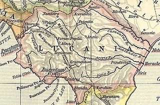
Fitxer:Lucania map.jpg

Fitxer original (910 × 598 píxels, mida del fitxer: 222 Ko, tipus MIME: image/jpeg)
| Aquest fitxer i la informació mostrada a continuació provenen del dipòsit multimèdia lliure Wikimedia Commons. |
| Descripció | ||||||
| Data | ||||||
| Font | File:Shepherd-c-030-031.jpg | |||||
| Autor |
Historical Atlas by William R. Shepherd 1911 edition
Reference: Reference Map of Ancient Italy, Southern Part Courtesy of the University of Texas Libraries, The University of Texas at Austin. [1] |
|||||
| Permís (Com reutilitzar aquest fitxer) |
|
|||||
| Altres versions | ||||||
Historial del fitxer
Cliqueu una data/hora per veure el fitxer tal com era aleshores.
| Data/hora | Miniatura | Dimensions | Usuari/a | Comentari | |
|---|---|---|---|---|---|
| actual | 15:36, 2 feb 2018 | | 910 × 598 (222 Ko) | HerrAdams | Reverted to version as of 14:57, 2 November 2014 (UTC); removed border |
| 17:03, 2 nov 2014 |  | 936 × 624 (243 Ko) | Cristiano64 | outer edge in black | |
| 17:02, 2 nov 2014 |  | 936 × 624 (243 Ko) | Cristiano64 | outer edge in black | |
| 16:57, 2 nov 2014 |  | 910 × 598 (222 Ko) | Cristiano64 | File more clear. It was too dark | |
| 10:57, 12 des 2006 |  | 704 × 423 (97 Ko) | Roke~commonswiki | Map of Lucania, cropped from old public domain map of Italy, from the Perry-Castañeda Library Map Collection, Historical Atlas by William R. Shepherd [http://www.lib.utexas.edu/maps/historical/shepherd/italy_ancient_north.jpg north], [http://www.lib.utex |
Ús del fitxer
Les 3 pàgines següents utilitzen aquest fitxer:
Ús global del fitxer
Utilització d'aquest fitxer en altres wikis:
- Utilització a ar.wikipedia.org
- Utilització a be.wikipedia.org
- Utilització a bg.wikipedia.org
- Utilització a bs.wikipedia.org
- Utilització a cs.wikipedia.org
- Utilització a el.wikipedia.org
- Utilització a en.wikipedia.org
- Utilització a es.wikipedia.org
- Utilització a eu.wikipedia.org
- Utilització a fa.wikipedia.org
- Utilització a fi.wikipedia.org
- Utilització a fr.wikipedia.org
- Utilització a fr.wiktionary.org
- Utilització a he.wikipedia.org
- Utilització a hr.wikipedia.org
- Utilització a id.wikipedia.org
- Utilització a it.wikipedia.org
- Utilització a ko.wikipedia.org
- Utilització a lmo.wikipedia.org
- Utilització a pl.wiktionary.org
- Utilització a pt.wikipedia.org
- Utilització a ru.wikipedia.org
- Utilització a scn.wikipedia.org
- Utilització a sh.wikipedia.org
- Utilització a sk.wikipedia.org
- Utilització a sv.wikipedia.org
Vegeu més usos globals d'aquest fitxer.