
Fitxer:Mangareva Island.jpg

Mida d'aquesta previsualització: 605 × 599 píxels. Altres resolucions: 242 × 240 píxels | 485 × 480 píxels | 646 × 640 píxels.
Fitxer original (646 × 640 píxels, mida del fitxer: 128 Ko, tipus MIME: image/jpeg)
| Aquest fitxer i la informació mostrada a continuació provenen del dipòsit multimèdia lliure Wikimedia Commons. |
Resum
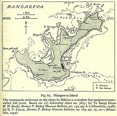
Old map of Mangareva, Gambier Islands.
Source: http://www.lib.utexas.edu/maps/historical/pacific_islands_1943_1945/mangareva_island.jpg PD, see http://www.lib.utexas.edu/maps/faq.html#3.html
Llicència
This file is in the public domain because it has been taken from a collection of public domain maps at the University of Texas Library
|
Historial del fitxer
Cliqueu una data/hora per veure el fitxer tal com era aleshores.
| Data/hora | Miniatura | Dimensions | Usuari/a | Comentari | |
|---|---|---|---|---|---|
| actual | 18:30, 3 oct 2006 | | 646 × 640 (128 Ko) | Ratzer | http://www.lib.utexas.edu/maps/historical/pacific_islands_1943_1945/mangareva_island.jpg PD, see http://www.lib.utexas.edu/maps/faq.html#3.html |
Ús del fitxer
La pàgina següent utilitza aquest fitxer:
Ús global del fitxer
Utilització d'aquest fitxer en altres wikis:
- Utilització a af.wikipedia.org
- Utilització a de.wikipedia.org
- Utilització a en.wikipedia.org
- Utilització a es.wikipedia.org
- Utilització a fr.wikipedia.org
- Utilització a mk.wikipedia.org
- Utilització a mrj.wikipedia.org
- Utilització a nl.wikipedia.org
- Utilització a pl.wikipedia.org
- Utilització a pt.wikipedia.org
- Utilització a ru.wikipedia.org
- Utilització a uk.wikipedia.org