
Fitxer:Map 61 - Bosnia - Srebrenica & Zepa, July 1995.jpg

Mida d'aquesta previsualització: 458 × 599 píxels. Altres resolucions: 183 × 240 píxels | 367 × 480 píxels | 587 × 768 píxels | 782 × 1.024 píxels | 1.679 × 2.197 píxels.
Fitxer original (1.679 × 2.197 píxels, mida del fitxer: 498 Ko, tipus MIME: image/jpeg)
| Aquest fitxer i la informació mostrada a continuació provenen del dipòsit multimèdia lliure Wikimedia Commons. |
Resum
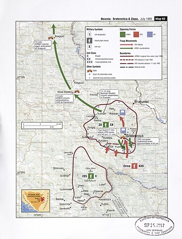
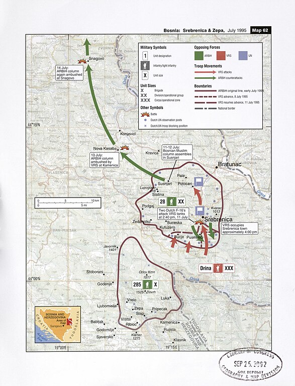
| Descripció | Map of military operations on July, 1995 against the town of Srebrenica |
| Data | |
| Font | Balkan Battlegrounds: A Military History of the Yugoslav Conflict; Map Case, 2002, Library of Congress (Original Size) |
| Autor | Central Intelligence Agency |
| Altres versions | Derivative works of this file: Map 61 - Bosnia - Srebrenica & Zepa, July 1995 hu.png |
Llicència
| This image is a work of a Central Intelligence Agency employee, taken or made as part of that person's official duties. As a Work of the United States Government, this image or media is in the public domain in the United States.
|

|
Historial del fitxer
Cliqueu una data/hora per veure el fitxer tal com era aleshores.
| Data/hora | Miniatura | Dimensions | Usuari/a | Comentari | |
|---|---|---|---|---|---|
| actual | 03:16, 9 oct 2016 | | 1.679 × 2.197 (498 Ko) | Ранко Николић | https://www.loc.gov/resource/g6841sm.gct00210/?sp=61 |
| 10:40, 26 maig 2006 |  | 697 × 896 (213 Ko) | Vercingetorix~commonswiki | Map of military operations during the Srebrenica massacre, July 1995 From "Balkan Battlegrounds", 2002 {{PD-USGov-CIA}} From: http://en.wikipedia.org/wiki/Image:Srebrenica_massacre_map.jpg |
Ús del fitxer
La pàgina següent utilitza aquest fitxer:
Ús global del fitxer
Utilització d'aquest fitxer en altres wikis:
- Utilització a ar.wikipedia.org
- Utilització a azb.wikipedia.org
- Utilització a az.wikipedia.org
- Utilització a be.wikipedia.org
- Utilització a bg.wikipedia.org
- Utilització a cs.wikipedia.org
- Utilització a da.wikipedia.org
- Utilització a en.wikipedia.org
- Utilització a es.wikipedia.org
- Utilització a eu.wikipedia.org
- Utilització a fa.wikipedia.org
- Utilització a fi.wikipedia.org
- Utilització a gl.wikipedia.org
- Utilització a he.wikipedia.org
- Utilització a hr.wikipedia.org
- Utilització a hu.wikipedia.org
- Utilització a is.wikipedia.org
- Utilització a it.wikipedia.org
- Utilització a ja.wikipedia.org
- Utilització a ka.wikipedia.org
- Utilització a ko.wikipedia.org
- Utilització a lt.wikipedia.org
- Utilització a mk.wikipedia.org
- Utilització a ms.wikipedia.org
- Utilització a no.wikipedia.org
- Utilització a ru.wikipedia.org
- Utilització a sh.wikipedia.org
- Utilització a sl.wikipedia.org
- Utilització a sr.wikipedia.org
- Utilització a tr.wikipedia.org
- Utilització a tt.wikipedia.org
- Utilització a uk.wikipedia.org
Vegeu més usos globals d'aquest fitxer.