
Fitxer:Map of Indians Texas 1500.png

Mida d'aquesta previsualització: 800 × 549 píxels. Altres resolucions: 320 × 220 píxels | 640 × 439 píxels | 1.024 × 703 píxels | 1.280 × 878 píxels | 2.308 × 1.584 píxels.
Fitxer original (2.308 × 1.584 píxels, mida del fitxer: 521 Ko, tipus MIME: image/png)
| Aquest fitxer i la informació mostrada a continuació provenen del dipòsit multimèdia lliure Wikimedia Commons. |
Resum
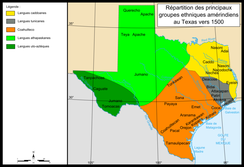
| Descripció | Map of Texas showing the location of Indian groups around 1500 as well as colors showing regions in which specific Indian languages were spoken. The Southwest of Texas is colored dark green for Lagues uo-azteques, and the groups in this region are Tanpachaos, Caguate, Jumano, and Tomoacas. The northwest is colored lime green for the Langues Athapaskanes and the groups in this area are the Querecho, Apache, Teya, and Jumano. The large southern section in the middle of the map is colored orange for Coahuilteco, and the groups in this region are the Tonkawan, Sana, Payaya, Emet, Coca, Aranama, Coahuiltecan, Karankawan, Kopano, Kahani, Orejon, Pacal, and Tamaulipecan. A small eastern section along the coast is colored grey for Langues tunicanes, and includes the groups Deacose, Bidai, Attacapan, Patiri, Akokna, and Atacapa. The northeast of the state is colored yellow for Langues caddoanes, and contains the groups of Nasoni, Caddo, Adai, Nacodoche, Neches, and Eyeish. |
| Data | 13 de setembre de 2008 (original upload date) |
| Font | No machine-readable source provided. Own work assumed (based on copyright claims). |
| Autor | No machine-readable author provided. Urban~commonswiki assumed (based on copyright claims). |
Llicència
| Jo, el titular del copyright d'aquesta obra, l'allibero al domini públic. Això s'aplica a tot el món. En alguns països això pot no ser legalment possible, en tal cas: Jo faig concessió a tothom del dret d'usar aquesta obra per a qualsevol propòsit, sense cap condició llevat d'aquelles requerides per la llei. |
Historial del fitxer
Cliqueu una data/hora per veure el fitxer tal com era aleshores.
| Data/hora | Miniatura | Dimensions | Usuari/a | Comentari | |
|---|---|---|---|---|---|
| actual | 17:10, 13 set 2008 | | 2.308 × 1.584 (521 Ko) | Urban~commonswiki | category:maps of Texas |
Ús del fitxer
La pàgina següent utilitza aquest fitxer:
Ús global del fitxer
Utilització d'aquest fitxer en altres wikis:
- Utilització a bo.wikipedia.org
- Utilització a en.wikipedia.org
- Utilització a es.wikipedia.org
- Utilització a fr.wikipedia.org
- Utilització a it.wikipedia.org
- Utilització a sr.wikipedia.org
- Utilització a tr.wikipedia.org