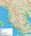
Fitxer:Map of ancient Epirus and environs (English).svg

El contingut de la pàgina no s'admet en altres llengües.
De la Viquipèdia, l'enciclopèdia lliure

Fitxer original(fitxer SVG, nominalment 1.303 × 1.500 píxels, mida del fitxer: 495 Ko)

Descripció a Commons
Translate this file Aquest fitxer SVG inclou text encapsulat que es pot traduir al vostre idioma utilitzant un editor que admeti SVG, un editor de text o l'eina de traducció de SVG. Per a més informació vegeu l'ajuda de traducció de fitxers SVG.

Resum

Descripció
English: Map of ancient Epirus & Environs, Thracian, Illyrian, Paeonian, & Greek contact zones with illustration and extent of Hellenization up to the creation of Epirus Nova or Illyria Graeca
Data
Font Treball propi
Autor MaryroseB54
Altres versions

[modifica]

  • The classical age of Greece (1999),
  • ed. Atlas of the Greek and Roman world in antiquity (1981).
  • Hammond, N. G. L. A History of Greece to 322 B.C., 1986, ISBN-10: 0198730950
  • Wilkes, J. J. The Illyrians, 1992,ISBN 0631198075, (i.e. pages 174, 208, 210, 273)
  • In the Shadow of Olympus: The Emergence of Macedon,ISBN 0691008809,1992
  • Thracian Tribal areas (from Fol, Thrace and the Thracians, p 133),The Thracians 700 BC–AD 46 (Men-at-Arms 360) by Christopher Webber After Hoddinot, Col & Cah
  • Hendry, p. 299. The geography is entirely correct for Servius' time, since Diocletian's rearrangement of provincial boundaries included the creation of the province of Epirus Nova out of southern Illyricum with Dyrrachium (=Epidamnus) as its capital.
  • The Loeb Editor's Notes, 28 Nova Epirus or Illyris Graeca (Epirus, Nova Illyria Graeca) "Nova Epirus or Illyris Graeca extended from the Drilo (Mod. Drina) River on the north to the Ceraunian Mts. on the south, thus comprising a large part of modern Albania. Immediately to the south of it to the Ambracian Gulf (Mod. Gulf of Arta) lay what is here called Old Epirus, approximately identical with the Epirus of modern Greece."
  • Soustal, Peter; Koder, Johannes (1981). Tabula Imperii Byzantini, Band 3: Nikopolis und Kephallenia (in German). Vienna: Verlag der Osterreichischen Akademie der Wissenschaften. ISBN 3-7001-0399-9., page 47
  • A new classical dictionary of Greek and Roman biography, mythology, and geography: partly based upon the Dictionary of Greek and Roman biography and mythology by Sir William Smith,1851,page 392 "B. Illyris Graeca, which was called in later times Epirus Nova, extended from the river Drilo to the SE., up to the Ceraunian mountains, which separated it from Epirus Proper"
  • American journal of philology, Τόμοι 98-99,by JSTOR (Organization), Project Muse,1977,page 263, the partly Hellenic and partly Hellenized Epirus Nova
  • Epirus Vetus: The Archaeology of a Late Antique Province (Duckworth Archaeology) by William Bowden,2003,ISBN-10: 0715631160,2003,page 233,of Lissos in Epirus Nova
  • Migrations and invasions in Greece and adjacent areas by Nicholas Geoffrey Lempriere Hammond,1976,ISBN -0815550472,page 54,The line of division between Illyricum and the Greek area Epirus nova
  • Athanassakis, A.N. (1977), "N.G.L. Hammond, Migrations and Invasions in Greece and Adjacent Areas (review)", American Journal of Philology 99: 263–6, JSTOR 293653
  • Hammond, N. G. L. A History of Greece to 322 B.C., 1986, ISBN-10: 0198730950
  • Triadafilopoulos, Triadafilos (November 2000). "Power politics and nationalist discourse in the struggle for 'Northern Epirus': 1919-1921". Journal of Southern Europe and the Balkans,
  • Encyclopedia Britannica,2002,ISBN -0852297874,The Roman province of Illyricum stretched from the Drilon River (the Drin, in modern Albania) in the south to Istria (modem Slovenia and Croatia)
  • History of the Byzantine Empire: Vol. 1, 324-1453 (Paperback) by Alexander A. Vasiliev
  • Epire, Illyrie, Macedoine: melanges offerts au professeur Pierre Cabanes by Daniele Berranger,Pierre Cabanes,Daniele Berranger-Auserve,page 130
  • In An Inventory of Archaic and Classical Poleis by Mogens Herman, ISBN 0-19-814099-1, 2004, i.e. "As a long-distance trading community, Aigina was not an active coloniser, but colonised Kydonia (no. 968) in 519, Adria (no. 75) c.C61, and Damastion in Illyria after 431 (Strabo 8.6.16)." & page 348
  • The Cambridge Ancient History: The Hellenistic monarchies and the rise of Rome, 1964. page 836 "of mixed barbarian and Greek population, such as Dimale (or Dimallum), of unknown"
  • The Illyrian Atintani, the Epirotic Atintanes and the Roman Protectorate N. G. L. Hammond, The Journal of Roman Studies Vol. 79 (1989), pp. 11-25 "There were Illyrian Amantini in Pannonia and Greek Amantes in North Epirus"
  • Blank map from Image:Map greek sanctuaries-fr.svg (The empty map used is not topographic, nor does it offer the capacity of gps precision, but its easy on the eyes and aesthetically pleasing in general)

Llicència

Jo, el titular dels drets d'autor d'aquest treball, el public sota la següent llicència:
w:ca:Creative Commons
reconeixement compartir igual
This file is licensed under the Creative Commons Attribution-Share Alike 4.0 International license.
Sou lliure de:
  • compartir – copiar, distribuir i comunicar públicament l'obra
  • adaptar – fer-ne obres derivades
Amb les condicions següents:
  • reconeixement – Heu de donar la informació adequada sobre l'autor, proporcionar un enllaç a la llicència i indicar si s'han realitzat canvis. Podeu fer-ho amb qualsevol mitjà raonable, però de cap manera no suggereixi que l'autor us dóna suport o aprova l'ús que en feu.
  • compartir igual – Si modifiqueu, transformeu, o generareu amb el material, haureu de distribuir les vostres contribucions sota una llicència similar o una de compatible com l'original
Anotacions
InfoField
Aquesta imatge té anotacions: Vegeu-les a Commons

Llegendes

Afegeix una explicació d'una línia del que representa aquest fitxer

Elements representats en aquest fitxer

representa l'entitat

Historial del fitxer

Cliqueu una data/hora per veure el fitxer tal com era aleshores.

Data/horaMiniaturaDimensionsUsuari/aComentari
actual06:38, 22 nov 2021Miniatura per a la versió del 06:38, 22 nov 20211.303 × 1.500 (495 Ko)KhirurgMeant to upload this version
06:22, 22 nov 2021Miniatura per a la versió del 06:22, 22 nov 20211.303 × 1.500 (495 Ko)KhirurgMade some corrections
03:36, 28 des 2020Miniatura per a la versió del 03:36, 28 des 20201.303 × 1.500 (493 Ko)CastellFile uploaded using svgtranslate tool (https://svgtranslate.toolforge.org/). Added translation for ca.
03:26, 28 des 2020Miniatura per a la versió del 03:26, 28 des 20201.303 × 1.500 (492 Ko)CastellFile uploaded using svgtranslate tool (https://svgtranslate.toolforge.org/). Added translation for ca.
13:15, 24 juny 2016Miniatura per a la versió del 13:15, 24 juny 20161.303 × 1.500 (383 Ko)MaryroseB54Parthos
01:58, 23 juny 2016Miniatura per a la versió del 01:58, 23 juny 20161.303 × 1.500 (382 Ko)MaryroseB54as per source
00:52, 23 juny 2016Miniatura per a la versió del 00:52, 23 juny 20161.303 × 1.500 (382 Ko)MaryroseB54Position
23:07, 22 juny 2016Miniatura per a la versió del 23:07, 22 juny 20161.303 × 1.500 (382 Ko)MaryroseB54Position fix
12:06, 20 juny 2016Miniatura per a la versió del 12:06, 20 juny 20161.303 × 1.500 (382 Ko)MaryroseB54User created page with UploadWizard

Les 5 pàgines següents utilitzen aquest fitxer:

Ús global del fitxer

Metadades