Fitxer:Nile River and delta from orbit.jpg

El contingut de la pàgina no s'admet en altres llengües.
De la Viquipèdia, l'enciclopèdia lliure

Nile_River_and_delta_from_orbit.jpg(700 × 550 píxels, mida del fitxer: 85 Ko, tipus MIME: image/jpeg)

Descripció a Commons

Resum

Descripció

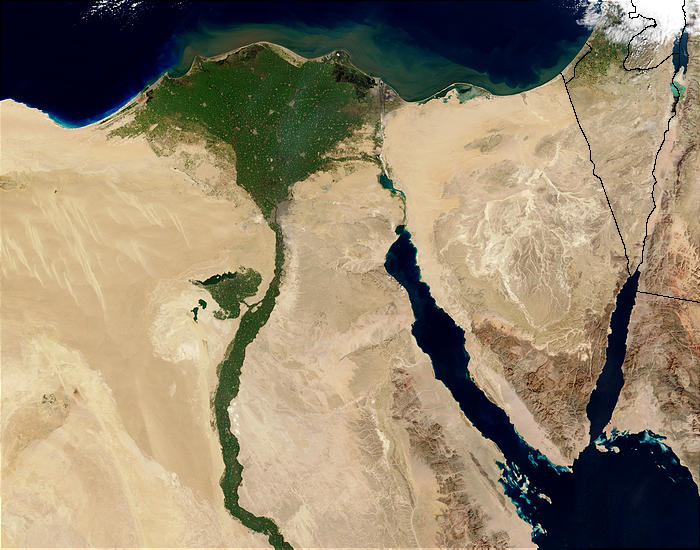
Nile River and delta from orbit Description: The Nile River and delta as seen from space by the MODIS sensor on the Terra satellite.

"Against the barren desert of northeastern Africa, the fertile valley of the Nile River runs northward through Egypt. In the higher-resolution images, the city of Cairo can be seen as a gray smudge right where the river widens into its broad fan-shaped delta. Other cities are dotted across the green landscape, giving it a speckled appearance. Where the Nile empties into the Mediterranean Sea (top) the waters are swirling with color, likely a mixture of sediment, organic matter, and possibly marine plant life. Farther west, the bright blue color of the water is likely less-organically rich sediment, perhaps sand.
"East of the delta lies the arid Sinai Peninsula, whose pointed tip is home to rugged mountains, some as high as 8,600 feet. The lattice work of pale lines marks the paths of ephemeral rivers. The Sinai Peninsula intrudes into the Red Sea. Farther east are Israel, Jordan, and Saudi Arabia. At top right is the disputed territory of the West Bank.
"In the false-color image, vegetation is bright green, water is dark blue or black, and clouds are light blue. It's interesting to notice that places that seem essentially arid, or desert-like in the true-color image in fact have a delicate layer of vegetation. For example, the central Sinai Peninsula, and most of Israel have a faint greenish tinge in the false-color images.
Data
Font http://visibleearth.nasa.gov/view_rec.php?id=4927 [1]
Autor Jacques Descloitres, MODIS Rapid Response Team, NASA/sh
Altres versions Cuaggjacgacugvajgca

Salchicha

Llicència

Public domain Aquest fitxer és en el domini públic perquè ha estat creat per la NASA. L'avís legal de la NASA diu que «el material de la NASA no està protegit per copyright si no es diu el contrari». (NASA copyright policy page o JPL Image Use Policy).
Atenció:
  • L'ús dels logotips de la NASA, insígnies i emblemes està restringit la llei dels EUA 14 CFR 1221.
  • El lloc web de la NASA disposa d'un gran nombre d'imatges de l'Agència Espacial Russa, o soviètica, i d'altres agències no nord-americanes. Aquestes imatges no són necessàriament en el domini públic.
  • El material del Telescopi espacial Hubble pot tenir els drets reservats si no prové explícitament del STScI. [2]
  • Tot el material de la sonda SOHO està reservat i requereix d'autorització per a un ús comercial no educatiu. [3]
  • Les imatges destacades en el lloc web Astronomy Picture of the Day (APOD) poden tenir drets d'autor. [4]

Llegendes

Afegeix una explicació d'una línia del que representa aquest fitxer
Nile delta

Elements representats en aquest fitxer

representa l'entitat

Historial del fitxer

Cliqueu una data/hora per veure el fitxer tal com era aleshores.

Data/horaMiniaturaDimensionsUsuari/aComentari
actual00:47, 30 nov 2004Miniatura per a la versió del 00:47, 30 nov 2004700 × 550 (85 Ko)MschlindweinNile River and delta from orbit

Les 5 pàgines següents utilitzen aquest fitxer:

Ús global del fitxer

Utilització d'aquest fitxer en altres wikis:

Vegeu més usos globals d'aquest fitxer.