
Fitxer:North America subduction.jpg
No hi ha cap versió amb una resolució més gran.
North_America_subduction.jpg (291 × 374 píxels, mida del fitxer: 20 Ko, tipus MIME: image/jpeg)
| Aquest fitxer i la informació mostrada a continuació provenen del dipòsit multimèdia lliure Wikimedia Commons. |


Resum
| Descripció |
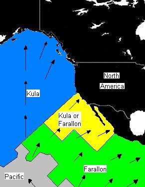
English: Plate distribution between 64 and 74 million years ago. Arrows represent direction of subduction along North America. Black represents present-day land area. |
| Data | |
| Font | Treball propi |
| Autor | Black Tusk |
Llicència
| Jo, el titular del copyright d'aquesta obra, l'allibero al domini públic. Això s'aplica a tot el món. En alguns països això pot no ser legalment possible, en tal cas: Jo faig concessió a tothom del dret d'usar aquesta obra per a qualsevol propòsit, sense cap condició llevat d'aquelles requerides per la llei. |
Historial del fitxer
Cliqueu una data/hora per veure el fitxer tal com era aleshores.
| Data/hora | Miniatura | Dimensions | Usuari/a | Comentari | |
|---|---|---|---|---|---|
| actual | 15:07, 4 set 2008 | | 291 × 374 (20 Ko) | Black Tusk | {{Information |Description={{en|1=Plate distribution between 64 and 74 million years ago. Arrows represent direction of subduction along North America.}} |Source=Own work by uploader |Author=Black Tusk |Date=September 4, 2008 |Permissi |
Ús del fitxer
La pàgina següent utilitza aquest fitxer:
Ús global del fitxer
Utilització d'aquest fitxer en altres wikis:
- Utilització a en.wikipedia.org
- Utilització a fr.wikipedia.org
- Utilització a it.wikipedia.org
- Utilització a ko.wikipedia.org
- Utilització a oc.wikipedia.org
- Utilització a ru.wikipedia.org
- Utilització a uk.wikipedia.org
- Utilització a zh.wikipedia.org