
Fitxer:PIA21136 Scalloped Terrain Led to Finding of Buried Ice on Mars.jpg
PIA21136_Scalloped_Terrain_Led_to_Finding_of_Buried_Ice_on_Mars.jpg (640 × 398 píxels, mida del fitxer: 57 Ko, tipus MIME: image/jpeg)
| Aquest fitxer i la informació mostrada a continuació provenen del dipòsit multimèdia lliure Wikimedia Commons. |
Resum
| Descripció |
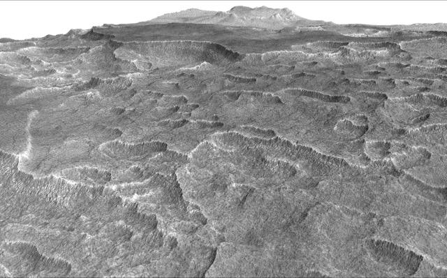
English: This vertically exaggerated view shows scalloped depressions in Mars' Utopia Planitia region, one of the area's distinctive textures that prompted researchers to check for underground ice, using ground-penetrating radar aboard NASA's Mars Reconnaissance Orbiter.
More than 600 overhead passes with the spacecraft's Shallow Radar (SHARAD) instrument provided data for determining that about as much water as the volume of Lake Superior lies in a thick layer beneath a portion of Utopia Planitia. These scalloped depressions on the surface are typically about 100 to 200 yards or meters wide. The foreground of this view covers ground about one mile (1.8 kilometers) across. The perspective view is based on a three-dimensional terrain model derived from a stereo pair of observations by the High Resolution Imaging Science Experiment (HiRISE) camera on the Mars Reconnaissance Orbiter. One was taken on Dec. 25, 2006, the other on Feb. 2, 2007. The vertical dimension is exaggerated fivefold in proportion to the horizontal dimensions, to make texture more apparent in what is a rather flat plain. Similar scalloped depressions are found in portions of the Canadian Arctic, where they are indicative of ground ice. The University of Arizona, Tucson, operates HiRISE, which was built by Ball Aerospace & Technologies Corp., Boulder, Colo. NASA's Jet Propulsion Laboratory, a division of Caltech in Pasadena, California, manages the Mars Reconnaissance Orbiter Project for NASA's Science Mission Directorate, Washington. |
| Data | (published 22 de novembre de 2016) |
| Font | Catalog page · Full-res (JPEG · TIFF) |
| Autor | NASA/JPL-Caltech/Univ. of Arizona |
Aquest fitxer ha estat catalogat per Jet Propulsion Lab dels Estats Units d'Amèrica per a l'Administració Nacional d'Aeronàutica i de l'Espai (NASA)en virtut identificat com a: ID del fitxer : PIA21136.Els ID dels fitxers i ID alternatius són traduïts de Photo ID .Aquesta etiqueta no indica l'estat dels drets d'autor de la imatge carregada. Cal un senyal de drets d'autor. Vegeu Commons:Sobre les llicències. Altres idiomes:
|
 |
This media is a product of the Mars Reconnaissance Orbiter mission Credit and attribution belongs to the High Resolution Imaging Science Experiment (HiRISE) team, NASA/JPL-Caltech/Univ. of Arizona |
Llicència
| Aquest fitxer és en el domini públic perquè ha estat creat per la NASA. L'avís legal de la NASA diu que «el material de la NASA no està protegit per copyright si no es diu el contrari». (NASA copyright policy page o JPL Image Use Policy). | ||
 |
Atenció:
|
Historial del fitxer
Cliqueu una data/hora per veure el fitxer tal com era aleshores.
| Data/hora | Miniatura | Dimensions | Usuari/a | Comentari | |
|---|---|---|---|---|---|
| actual | 00:05, 24 nov 2016 | | 640 × 398 (57 Ko) | Drbogdan | User created page with UploadWizard |
Ús del fitxer
Les 2 pàgines següents utilitzen aquest fitxer:
Ús global del fitxer
Utilització d'aquest fitxer en altres wikis:
- Utilització a ar.wikipedia.org
- Utilització a bn.wikipedia.org
- Utilització a el.wikipedia.org
- Utilització a en.wikipedia.org
- Utilització a eo.wikipedia.org
- Utilització a es.wikipedia.org
- Utilització a kk.wikipedia.org
- Utilització a ru.wikipedia.org
- Utilització a zh.wikipedia.org