
Fitxer:ProtectorateOfSouthArabiaMap.jpg

Mida d'aquesta previsualització: 800 × 584 píxels. Altres resolucions: 320 × 234 píxels | 640 × 467 píxels | 912 × 666 píxels.
Fitxer original (912 × 666 píxels, mida del fitxer: 273 Ko, tipus MIME: image/jpeg)
| Aquest fitxer i la informació mostrada a continuació provenen del dipòsit multimèdia lliure Wikimedia Commons. |

|
Aquesta imatge (de tipus historical map) s'hauria de tornar a crear utilitzant gràfics vectorials com ara un fitxer SVG. Això té diversos avantatges; en trobareu més informació a Commons:Media for cleanup. Si ja disposeu d'una versió d'aquesta imatge en format SVG, us preguem que la pengeu; després, reemplaceu aquesta plantilla amb la plantilla {{Vector version available|nom nou de la imatge.svg}} en aquesta imatge.
|


|
This map has been uploaded by Electionworld from en.wikipedia.org to enable the |
Resum
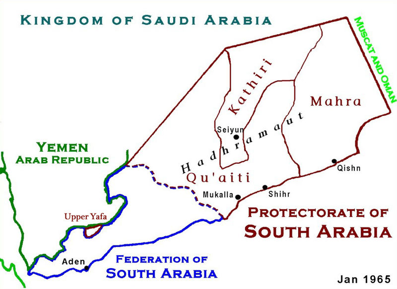
Based on Work of US Government agency. Another version in russian is available.
Llicència
Aquesta obra és en el domini públic als Estats Units perquè és una obra del govern federal dels Estats Units sota els termes del Títol 17, Capítol 1, Secció 105 del Codi dels EUA. Vegeu drets d'autor.
Nota: Això només s'aplica a obres del Govern Federal i no a les dels estats individuals ni cap altra subdivisió administrativa. Aquesta plantilla tampoc no s'aplica a dissenys de segells de correus publicats pel Servei Postal dels Estats Units des de 1978 (vegeu 206.02(b) of Compendium II: Copyright Office Practices).
|
 | |
| Aquest fitxer està identificat com a lliure de restriccions conegudes sota la llei de drets d'autor, inclosos els drets veïns. | ||
Historial del fitxer
Cliqueu una data/hora per veure el fitxer tal com era aleshores.
| Data/hora | Miniatura | Dimensions | Usuari/a | Comentari | |
|---|---|---|---|---|---|
| actual | 04:12, 18 gen 2010 | | 912 × 666 (273 Ko) | Anonimosanhueza | borders removed |
| 03:14, 28 nov 2008 |  | 928 × 682 (284 Ko) | Nickpo | {{svg|map}} {{ew|en|AjaxSmack}} == Summary == Based on Work of US Government agency == Licensing == {{PD-USGov}} Category:Maps of Yemen Category:Qu'aiti State of Shihr and Mukalla Category:Federation of South Arabia [[Category:Kathiri State | |
| 00:56, 18 des 2006 |  | 928 × 682 (118 Ko) | Electionworld | {{ew|en|AjaxSmack}} == Summary == Based on Work of US Government agency == Licensing == {{PD-USGov}} |
Ús del fitxer
Ús global del fitxer
Utilització d'aquest fitxer en altres wikis:
- Utilització a ar.wikipedia.org
- Utilització a be.wikipedia.org
- Utilització a bn.wikipedia.org
- Utilització a cs.wikipedia.org
- Utilització a de.wikipedia.org
- Utilització a en.wikipedia.org
- Utilització a es.wikipedia.org
- Utilització a fr.wikipedia.org
- Utilització a fr.wiktionary.org
- Utilització a hr.wikipedia.org
- Utilització a id.wikipedia.org
- Utilització a it.wikipedia.org
- Utilització a ja.wikipedia.org
- Utilització a lt.wikipedia.org
- Utilització a mk.wikipedia.org
- Utilització a no.wikipedia.org
- Utilització a pl.wikipedia.org
- Utilització a pnb.wikipedia.org
- Utilització a pt.wikipedia.org
- Utilització a ru.wikipedia.org
Vegeu més usos globals d'aquest fitxer.