
Fitxer:Rio Negro meanders.JPG

Mida d'aquesta previsualització: 800 × 531 píxels. Altres resolucions: 320 × 213 píxels | 640 × 425 píxels | 1.024 × 680 píxels | 1.280 × 850 píxels | 2.560 × 1.700 píxels | 4.288 × 2.848 píxels.
Fitxer original (4.288 × 2.848 píxels, mida del fitxer: 1,18 Mo, tipus MIME: image/jpeg)
| Aquest fitxer i la informació mostrada a continuació provenen del dipòsit multimèdia lliure Wikimedia Commons. |
| Descripció |
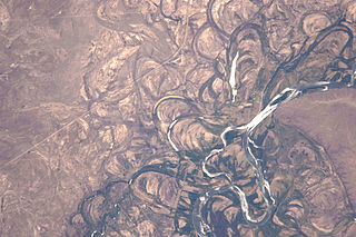
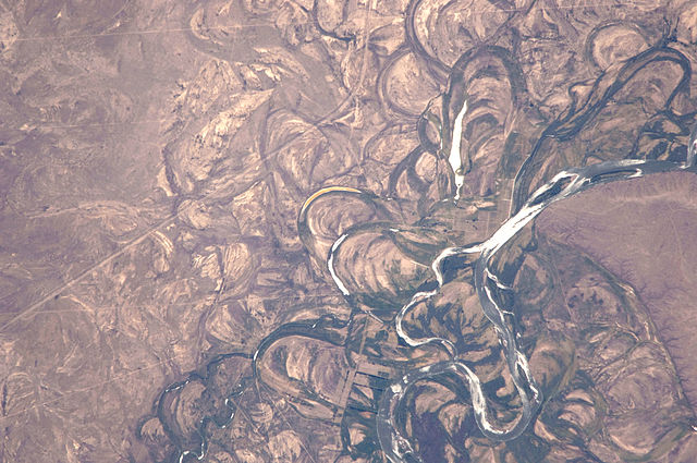
English: Country or Geographic Name: ARGENTINA
Features: RIO NEGRO, COLONEL JOSEFA AREA, FLOOD PLAIN Center Point Latitude: -39.8 Center Point Longitude: -65.4 |
|||||
| Data | Date: 20100104 (YYYYMMDD)GMT Time: 175502 (HHMMSS) | |||||
| Font | ftp://eol.jsc.nasa.gov/EFS_highres_ISS022_ISS022-E-19513.JPG via http://climate.nasa.gov/blogs/index.cfm?FuseAction=ShowBlog&NewsID=462 | |||||
| Autor | NASA Astronaut photograph ISS022-E-19513. | |||||
| Permís (Com reutilitzar aquest fitxer) |
|
|||||
| Altres versions | See http://eol.jsc.nasa.gov/scripts/sseop/photo.pl?mission=ISS022&roll=E&frame=19513 |

Historial del fitxer
Cliqueu una data/hora per veure el fitxer tal com era aleshores.
| Data/hora | Miniatura | Dimensions | Usuari/a | Comentari | |
|---|---|---|---|---|---|
| actual | 19:13, 16 nov 2014 | | 4.288 × 2.848 (1,18 Mo) | Ras67 | high resolution |
| 17:53, 2 març 2011 |  | 1.000 × 662 (689 Ko) | Tillman | {{Information |Description ={{en|1=Country or Geographic Name: ARGENTINA Features: RIO NEGRO, COLONEL JOSEFA AREA, FLOOD PLAIN Center Point Latitude: -39.8 Center Point Longitude: -65.4 }} |Source =ftp://eol.jsc.nasa.gov/EFS_highres_ISS022_ISS0 |
Ús del fitxer
La pàgina següent utilitza aquest fitxer:
Ús global del fitxer
Utilització d'aquest fitxer en altres wikis:
- Utilització a af.wikipedia.org
- Utilització a ar.wikipedia.org
- Utilització a ba.wikipedia.org
- Utilització a bh.wikipedia.org
- Utilització a bn.wikipedia.org
- Utilització a el.wikipedia.org
- Utilització a en.wikipedia.org
- Utilització a en.wikiversity.org
- Utilització a et.wikipedia.org
- Utilització a fr.wikipedia.org
- Utilització a he.wikipedia.org
- Utilització a hy.wikipedia.org
- Utilització a it.wikipedia.org
- Utilització a it.wikibooks.org
- Utilització a it.wikiversity.org
- Utilització a ja.wikipedia.org
- Utilització a pt.wikipedia.org
- Utilització a ru.wikipedia.org
- Utilització a sr.wikipedia.org
- Utilització a th.wikipedia.org
- Utilització a uk.wikipedia.org
- Utilització a www.wikidata.org
- Utilització a zh.wikipedia.org