
Fitxer:Roman provinces of Illyricum, Macedonia, Dacia, Moesia, Pannonia and Thracia.jpg

Mida d'aquesta previsualització: 740 × 600 píxels. Altres resolucions: 296 × 240 píxels | 592 × 480 píxels | 947 × 768 píxels | 1.263 × 1.024 píxels | 2.526 × 2.048 píxels | 2.817 × 2.284 píxels.
Fitxer original (2.817 × 2.284 píxels, mida del fitxer: 1,41 Mo, tipus MIME: image/jpeg)
| Aquest fitxer i la informació mostrada a continuació provenen del dipòsit multimèdia lliure Wikimedia Commons. |
| Descripció |
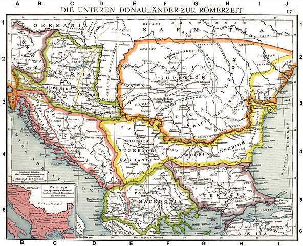
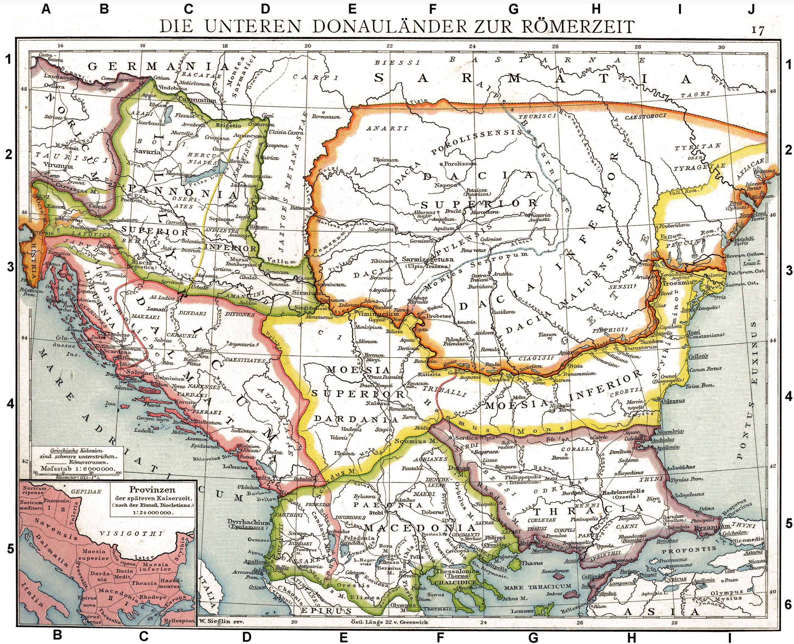
Deutsch: Die unteren Donauländer zur Römerzeit. Alte historische Karte aus Droysens Historischem Handatlas, 1886
English: The Roman provinces of the Lower Danube. Old historical map from Droysens Historical Atlas, 1886
Français : Provinces romaines d'Illyrie, de Macédoine, de Dacie, de Mésie, de Pannonie et de Thrace. Carte issue de l'Allgemeiner Historischer Handatlas de Gustav Droysen dirigé par Richard Andree, 1886. |
| Data | |
| Font | Allgemeiner historischer Handatlas in 96 Karten mit erläuterndem Text Bielefeld, Velhagen & Klasing 1886, S. 16. |
| Autor | Gustav Droysen (1838 — 1908) |
| Altres versions |
Derivative works of this file: |
.jpg)
|
Aquest material està en domini públic als Estats Units i als altres països on el dret d'autor s'estén per 100 anys (o menys) després de la mort de l'autor. | |
| Aquest fitxer està identificat com a lliure de restriccions conegudes sota la llei de drets d'autor, inclosos els drets veïns. | |
This work is in the public domain in the United States because it was published (or registered with the U.S. Copyright Office) before January 1, 1929.
Public domain works must be out of copyright in both the United States and in the source country of the work in order to be hosted on the Commons. If the work is not a U.S. work, the file must have an additional copyright tag indicating the copyright status in the source country.
Note: This tag should not be used for sound recordings. |
| Anotacions | Aquesta imatge té anotacions: Vegeu-les a Commons |
Historial del fitxer
Cliqueu una data/hora per veure el fitxer tal com era aleshores.
| Data/hora | Miniatura | Dimensions | Usuari/a | Comentari | |
|---|---|---|---|---|---|
| actual | 12:06, 11 set 2010 | | 2.817 × 2.284 (1,41 Mo) | DIREKTOR | Repairs |
| 21:22, 27 maig 2008 |  | 2.817 × 2.284 (1,75 Mo) | File Upload Bot (Magnus Manske) | {{BotMoveToCommons|en.wikipedia}} {{Information |Description={{en|Illyricum the Roman Province}} |Source=Transferred from [http://en.wikipedia.org en.wikipedia]; transfered to Commons by User:Koryakov Yuri using [http://tools.wikimedia.de/~magnus/com |
Ús del fitxer
Les 5 pàgines següents utilitzen aquest fitxer:
Ús global del fitxer
Utilització d'aquest fitxer en altres wikis:
- Utilització a als.wikipedia.org
- Utilització a an.wikipedia.org
- Utilització a ar.wikipedia.org
- Utilització a arz.wikipedia.org
- Utilització a ast.wikipedia.org
- Utilització a azb.wikipedia.org
- Utilització a az.wikipedia.org
- Utilització a be.wikipedia.org
- Utilització a bg.wikipedia.org
- Utilització a br.wikipedia.org
- Utilització a bs.wikipedia.org
- Utilització a da.wikipedia.org
- Utilització a de.wikipedia.org
- Thrakien (Landschaft)
- Geschichte Kroatiens
- Geschichte Sloweniens
- Illyrien
- Geschichte Ungarns
- Dalmatia
- Moesia
- Geschichte von Bosnien und Herzegowina
- Arad (Rumänien)
- Diskussion:Pannonia (Provinz)
- Pannonischer Aufstand
- Benutzer:Devil m25/Spielwiese
- Donaulimes
- Balkanromanische Sprachen
- Moesia inferior
- Via Militaris (Balkan)
- Diskussion:Serben/Archiv
- Biosphärenreservat Donaudelta
- Geschichte der Stadt Perg
- Taurisker
- Machland
- Keszthely-Kultur
- Benutzer Diskussion:Korrekturen/Archiv
- Illyrien (Provinz)
- Portugiesisch-rumänische Beziehungen
- Römische Streitkräfte in Moesia
Vegeu més usos globals d'aquest fitxer.