
Fitxer:Serbia ethnic02.png

Mida d'aquesta previsualització: 633 × 600 píxels. Altres resolucions: 253 × 240 píxels | 506 × 480 píxels | 728 × 690 píxels.
Fitxer original (728 × 690 píxels, mida del fitxer: 62 Ko, tipus MIME: image/png)
| Aquest fitxer i la informació mostrada a continuació provenen del dipòsit multimèdia lliure Wikimedia Commons. |
Resum
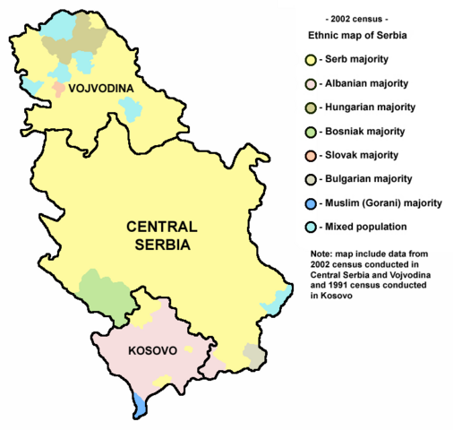
- English: ethnic map of Serbia (including Kosovo) according to 2002 census. Note: Map is based on the 2002 census data for Central Serbia and Vojvodina and 1991 census data for Kosovo.
- Serbian: етничка мапа Србије (укључујући Косово) према попису из 2002. године. Напомена: мапа је базирана на подацима са пописа из 2002. године у Централној Србији и Војводини и подацима са пописа из 1991. године на Косову.
References
- Republika Srbija, Republički zavod za statistiku, Saopštenje broj 295, godina LII, 24.12.2002, Konačni rezultati popisa 2002.
- Miodrag Milošević, Geografija za 8. razred osnovne škole, Beograd, 1994.
Source and licence

|
This map has been uploaded by Electionworld from en.wikipedia.org to enable the |
self made map by user:PANONIAN
| S'ha alliberat aquesta obra al domini públic pel seu autor PANONIAN. Això s'aplica a tot el món. En alguns països això pot no ser legalment possible, en tal cas: |
Historial del fitxer
Cliqueu una data/hora per veure el fitxer tal com era aleshores.
| Data/hora | Miniatura | Dimensions | Usuari/a | Comentari | |
|---|---|---|---|---|---|
| actual | 21:53, 15 gen 2014 | | 728 × 690 (62 Ko) | PANONIAN | Reverted to version as of 09:23, 6 September 2013 - map shows situation in 2002. it is historical map which have nothing to do with 2008 Kosovo politics |
| 20:19, 15 gen 2014 |  | 728 × 690 (45 Ko) | No More Cats | updated borders | |
| 11:23, 6 set 2013 |  | 728 × 690 (62 Ko) | PANONIAN | minor change | |
| 14:47, 10 gen 2012 |  | 728 × 690 (63 Ko) | PANONIAN | Reverted to version as of 04:32, 21 July 2009 - completelly unnecesary change | |
| 18:45, 9 gen 2012 |  | 728 × 690 (15 Ko) | Boskoigic | Greatly reduced file size by reducing color count to 12 colors. | |
| 06:32, 21 jul 2009 |  | 728 × 690 (63 Ko) | PANONIAN | ||
| 23:16, 18 jul 2009 |  | 728 × 690 (63 Ko) | PANONIAN | ||
| 16:19, 26 jul 2007 |  | 728 × 690 (28 Ko) | Nihad Hamzic | Greatly reduced file size by losslessly reducing color domain to 8-bit, etc. Image's appearance is the same. | |
| 22:34, 21 des 2006 |  | 728 × 690 (155 Ko) | Electionworld | {{ew|en|PANONIAN}} ethnic map of Serbia (self made) Note: Map is based on the 2002 census data for Central Serbia and Vojvodina and 1991 census data for Kosovo. {{PD-user|PANONIAN}} Category:Maps of Serbia Category:Ethnic maps |
Ús del fitxer
La pàgina següent utilitza aquest fitxer:
Ús global del fitxer
Utilització d'aquest fitxer en altres wikis:
- Utilització a an.wikipedia.org
- Utilització a arz.wikipedia.org
- Utilització a ast.wikipedia.org
- Utilització a bg.wikipedia.org
- Utilització a de.wikipedia.org
- Utilització a el.wikipedia.org
- Utilització a en.wikipedia.org
- Utilització a es.wikipedia.org
- Utilització a fi.wikipedia.org
- Utilització a fr.wikipedia.org
- Utilització a fr.wikiversity.org
- Utilització a gl.wikipedia.org
- Utilització a hr.wikipedia.org
- Utilització a it.wikipedia.org
- Utilització a lt.wikipedia.org
- Utilització a pl.wikipedia.org
- Utilització a pt.wikipedia.org
- Utilització a ro.wikipedia.org
- Utilització a sh.wikipedia.org
- Utilització a sq.wikipedia.org
- Utilització a sv.wikipedia.org
- Utilització a uk.wikipedia.org